walks roman
advertisement

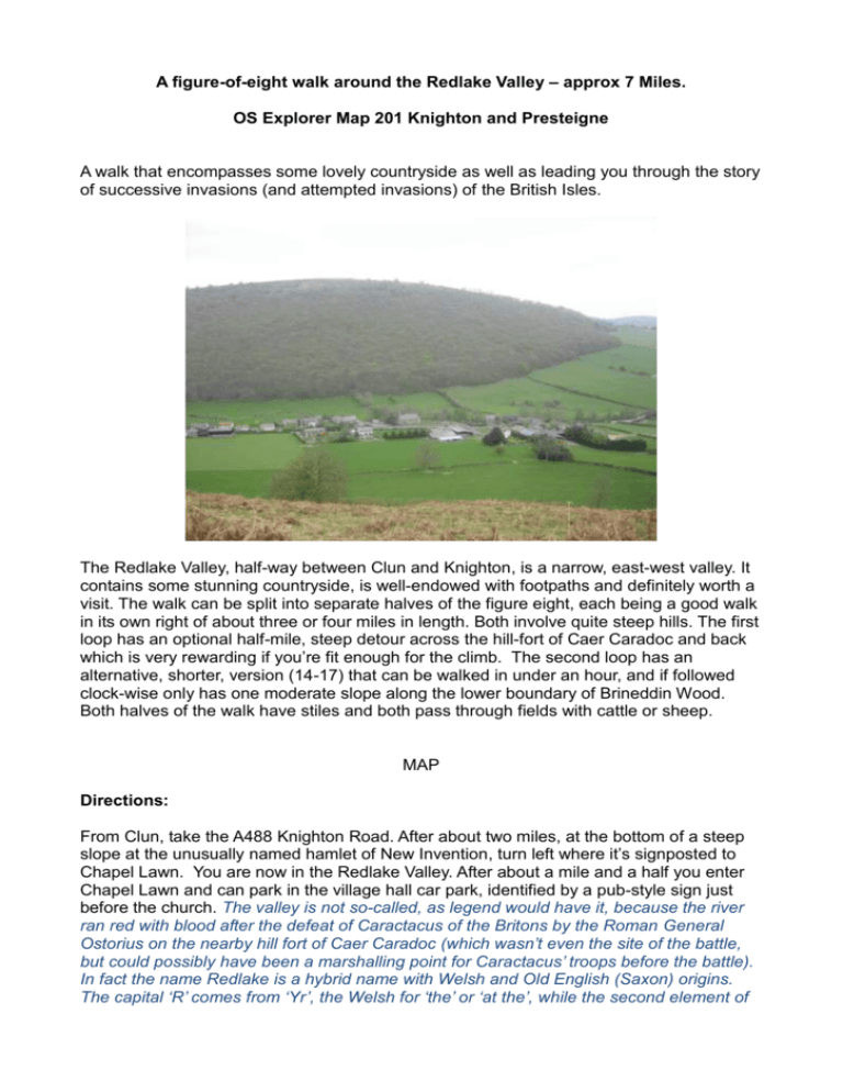
A figure-of-eight walk around the Redlake Valley – approx 7 Miles. OS Explorer Map 201 Knighton and Presteigne A walk that encompasses some lovely countryside as well as leading you through the story of successive invasions (and attempted invasions) of the British Isles. The Redlake Valley, half-way between Clun and Knighton, is a narrow, east-west valley. It contains some stunning countryside, is well-endowed with footpaths and definitely worth a visit. The walk can be split into separate halves of the figure eight, each being a good walk in its own right of about three or four miles in length. Both involve quite steep hills. The first loop has an optional half-mile, steep detour across the hill-fort of Caer Caradoc and back which is very rewarding if you’re fit enough for the climb. The second loop has an alternative, shorter, version (14-17) that can be walked in under an hour, and if followed clock-wise only has one moderate slope along the lower boundary of Brineddin Wood. Both halves of the walk have stiles and both pass through fields with cattle or sheep. MAP Directions: From Clun, take the A488 Knighton Road. After about two miles, at the bottom of a steep slope at the unusually named hamlet of New Invention, turn left where it’s signposted to Chapel Lawn. You are now in the Redlake Valley. After about a mile and a half you enter Chapel Lawn and can park in the village hall car park, identified by a pub-style sign just before the church. The valley is not so-called, as legend would have it, because the river ran red with blood after the defeat of Caractacus of the Britons by the Roman General Ostorius on the nearby hill fort of Caer Caradoc (which wasn’t even the site of the battle, but could possibly have been a marshalling point for Caractacus’ troops before the battle). In fact the name Redlake is a hybrid name with Welsh and Old English (Saxon) origins. The capital ‘R’ comes from ‘Yr’, the Welsh for ‘the’ or ‘at the’, while the second element of the name comes from a Saxon manor (‘ton’) of Adelectune, just beyond Bucknell at the very bottom of the valley, and now known as Adley. Say the two quickly, “Yr Adelactune”, and you can hear how ‘Redlake’ emerged. Standing in the car park, look south towards the bare slopes of Caer Caradoc to view the ground covered by the smaller, three-mile section of the figureeight. Then turn around and look north towards the steeply wooded side of Brineddin Hill around which the larger section of about four miles runs. During World War 2, the Chapel Lawn Home Guard mounted a look-out and searchlight post on the top of Brineddin Hill. They never encountered enemy aircraft, but they certainly saw the nighttime glow from the Black Country, Birmingham and Coventry as the result of enemy bombing raids. The southern, shorter section: 1. Walk east out of the village past St Mary’s Church (built 1844) towards Bucknell. On your right note the listed barns of Chapel Lawn Farm (Owen), one of which may have been the original chapel built in 1513 from which the village takes its name. On your left is Chapel Lawn Farm (Middleton). The house is quite recent, having been built in about 1890 by WH Davies, previously a pianoforte maker in Liverpool and former treasurer of the Liverpool Astronomical Society. However the stone part of the long barn alongside the road on your left is still known as the ‘old house’ and dates from the 17th Century if not earlier. 2. Walk past Well House and Masher’s Barn holiday cottage on the right, pausing briefly by the river Redlake to look for dippers and kingfishers. Then take the lane on rhs signposted Squire Farm (318763). Squire Farm’s name probably comes from the Welsh ‘Ysgair’, meaning a steep bank. 3. On reaching Squire Farm (322718) don’t enter the gateway but turn sharply back to your right and walk due west up a stony lane, eventually passing Smiling Tree Farm on lhs. Smiling Tree is a recent name but the farm was previously known as Bryncambric, and w as built in 1501 by William Jenkes, a wealthy tax-collector from Clun, and so-called because his family was descended from the ancient Welsh family of ‘the Cambrae’. ‘Bryn’ simply means ‘hill’. 4. Shortly after Smiling Tree and just before Little Bryncambric Farm, turn right through an aluminium kiss gate (316758) and walk through a copse to another kiss gate (315758). 5. Do not walk up the steep hillside to your left, but take the sloping path with views of Chapel Lawn below. In years gone by this path was much narrower, but when the Owen family bought Chapel Lawn Farm in 1891 they ploughed higher up the slopes than before, so had to widen the path in order that the horses plough could turn their ploughs around. 6. On reaching a stile on lhs (311760) you have the option of a steep but highly recommended detour up to the ancient hill fort of Caer Caradoc. if taking the detour, cross the stile and pick the easiest route up to the hill fort. Walk through the entrance, noting the size of the ditches and banks, all dug by hand. Follow a well-marked track right across the oval fort to the gateway on the other side. Once you are at the other side of the hill fort, climb the ditches to appreciate the view across to the Teme Valley and Offa’s Dyke Path about two miles away. On a clear day you can see the Brecon Beacons to the west, the Long Myndd to the north, Titterstone Clee Hill to the east and beyond that the Malvern Hills. When you can pull yourself away from the views and the sound of the skylarks above you, retrace your steps to where you left the main route if you’re not taking detour, carry straight on along the footpath across the fields to a tarmac lane (303763). If the field has been recently ploughed, try to spot a flint arrowhead glinting in the sunlight (if there is sunlight!). One was found there in 2012. 7. Turn right and walk down the lane to the junction (310765) with the road that connects New Invention to Chapel Lawn (if you only want to do the first half of the walk, turn right here and walk back to the village).Chapel Lawn was known as Hobendred until the late 18th Century. This earlier name is a corruption of the Old English ‘Edreteshop’, meaning ‘Edric’s Valley’. Edric was the real, but later fabled Wild Eric whose lands were seized by the Normans in 1066, so mounted a rearguard battle against the incomers, taking his band of English and Welsh followers to the woods in true Robin Hood fashion. ‘Edreteshop’ became Hobendred because the French spoken by the Norman scribes when the Domesday book was written inverted the two halves of the word. Therefore in translation it read ‘valley of Edric (or Endred)’. The northern, longer section: 8. Turn left and walk a short distance along the road until you see some white railings on rhs. The gate on the far side of the turning leads into a field called Dol y felin, which is Welsh for ‘Mill Meadow’. There is no sign of a mill nor any known record, but being a Welsh word, this almost certainly dates any former mill to the Middle Ages. In 1401 Prince Owain Glyndwr of Wales laid waste to many churches and mills in this part of the country. This, plus the passage of time, may explain the absence of any remains. 9. Take the turning right to the hamlet of Pentre. 10. Walk through Pentre and just before Wheelbarrow Bridge (309772) take the bridle path on rhs to Bergam (317776). Many names with ‘wheel’, ‘well’ or other ‘W vowel L’ forms date from the Saxon invasion during the Dark Ages when the Welsh were known by the invaders as ‘Walia’, meaning ‘foreigners’. The presence of ‘Woolbury’, a similar named spot just the other side of the hill towards called Clun suggests that the area was a ‘burgh’ or ‘fortified area’ occupied by the Welsh at the time of the invasion, and maybe afterwards if co-existence took place. 11. After about half a mile of walking slightly uphill, arrive at the junction of paths just below Bergam Farm and turn right to follow the path steeply up the hill where it emerges from the fields to a junction of roads (319779). 12. Turn right and follow the lane in south easterly direction up a gentle slope then down steeply to a 'T' Junction at Pentre Hodre Farm (327770) 13. Turn right at the ‘T’ junction and walk between buildings down a dip and up to another 'T' junction. 14. Pause here beside Pentre Hodre Pond (326767), home to newts and frogs. The weed in the pond builds up rapidly so is cleared out annually by local volunteers. The Black Poplar tree nearby was grown from a cutting of the famous Black Poplar at Aston-on-Clun which fell down during a storm in 1995. 15. Take the lane downhill towards Chapel Lawn, but shortly after passing the white house on lhs find a stile on rhs (325766) and take this path across the field to Brineddin Wood (if you wish to cut the walk short here you can carry on down the lane to Chapel Lawn). Brineddin means ‘Gorse Hill’ from ‘bryn’ plus ‘eithion’ the Welsh for ‘hill’ and ‘gorse’. For the first 100 metres or so you are walking through a part of the wood that was once called ‘Gwellinharat or ‘Angharad’s bed’, ‘gwel’ being the Welsh for ‘bed’. It is possible that this was named after Angahrad Colunwy (i.e. of Clun) born in the neighbourhood in about 1470. She was a daughter of Hywel Colunwy, a minor Welsh nobleman of the tribe of Elystan Glodrydd whose descendants ruled a minor principality in mid Wales, part of Rhwng 16. Gwy a Hafren - the land between the Wye and the Severn, which probably included the Redlake Valley. 17. Walk right through wood along its lower edge. Half way through the wood there is a log bench to rest on, and a path with rustic steps leading up through the wood to another bench higher up. This is a delightful spot to rest and enjoy the tranquillity of the wood or, if it’s a windy day, the drama of the Sessile Oaks swaying in the wind. The main body of the wood is divided into un-fenced, narrow strips or ‘quillets’, each of about two or three acres. Originally each quillet was attached to a house in the village for the purposes of firewood, fencing materials etc. Quite a few are still locally owned including this one with the seats, which was bought by the Redlake Valley Community Benefit Society in order that people may enter and enjoy the wood. 18. On leaving the wood, and just past Rock Cottage on your right at map ref (310766) take a sharp turn back beside Pentre Farm House onto a footpath that leads back to Chapel Lawn (if you pass between two cottages and link up with your earlier route you have gone too far). 19. Study the map carefully to find the correct route across the fields back to Chapel Lawn.


