Global Positioning System
I
INTRODUCTION
Global
Positioning
System (GPS), space-based radio-navigation
system
(see
Navigation), consisting of 24 satellites and ground support. GPS provides users
with accurate information about their position and velocity, as well as the time,
anywhere in the world and in all weather conditions.
II
HISTORY AND DEVELOPMENT
GPS, formally known as the Navstar Global Positioning System, was initiated in
1973 to reduce the proliferation of navigation aids. GPS is operated and
maintained by the United States Department of Defense. By creating a system
that overcame the limitations of many existing navigation systems, GPS became
attractive to a broad spectrum of users. GPS has been successful in classical
navigation applications, and because its capabilities are accessible using small,
inexpensive equipment, GPS has also been used in many new applications.
© Microsoft Corporation. All Rights Reserved.
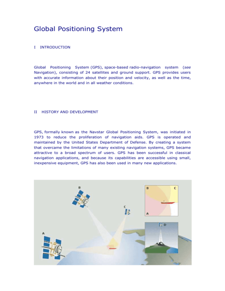
Finding Location with GPS
Global Positioning System (GPS) satellites orbit high above the surface of Earth at precise locations.
They allow a user with a GPS receiver to determine latitude, longitude, and altitude. The receiver
measures the time it takes for signals sent from the different satellites (A, B, and C) to reach the
receiver. From this data, the receiver triangulates an exact position. At any given time there are
multiple satellites within the range of any location on Earth. Three satellites are needed to determine
latitude and longitude, while a fourth satellite (D) is necessary to determine altitude.
III
HOW GPS WORKS
GPS determines location by computing the difference between the time that a
signal is sent and the time it is received. GPS satellites carry atomic clocks that
provide extremely accurate time (see Clocks and Watches: Atomic Clocks). The
time information is placed in the codes broadcast by the satellite so that a
receiver can continuously determine the time the signal was broadcast. The signal
contains data that a receiver uses to compute the locations of the satellites and to
make other adjustments needed for accurate positioning. The receiver uses the
time difference between the time of signal reception and the broadcast time to
compute the distance, or range, from the receiver to the satellite. The receiver
must account for propagation delays, or decreases in the signal's speed caused
by the ionosphere and the troposphere. With information about the ranges to
three satellites and the location of the satellite when the signal was sent, the
receiver can compute its own three-dimensional position.
An atomic clock synchronized to GPS is required in order to compute ranges from
these three signals. However, by taking a measurement from a fourth satellite,
the receiver avoids the need for an atomic clock. Thus, the receiver uses four
satellites to compute latitude, longitude, altitude, and time.
NASA
GPS System
The Navstar Global Positioning System (GPS) is a network of 24 satellites in orbit around the earth
that provides users with information about their position and movement. A GPS receiver computes
position information by comparing the time taken by signals from three or four different GPS satellites
to reach the receiver.
IV
THE PARTS OF GPS
GPS comprises three segments: the space, control, and user segments. The
space segment includes the satellites and the Delta rockets that launch the
satellites from Cape Canaveral, in Florida. GPS satellites fly in circular orbits at an
altitude of 20,100 km (12,500 mi) and with a period of 12 hours. The orbits are
tilted to the earth's equator by 55 degrees to ensure coverage of polar regions.
Powered by solar cells, the satellites continuously orient themselves to point their
solar panels toward the sun and their antennas toward the earth. Each satellite
contains four atomic clocks.
The control segment includes the master control station at Falcon Air Force Base
in Colorado Springs, Colorado, and monitor stations at Falcon Air Force Base and
on Hawaii, Ascension Island in the Atlantic Ocean, Diego Garcia Atoll in the Indian
Ocean, and Kwajalein Island in the South Pacific Ocean. These stations monitor
the GPS satellites. The control segment uses measurements collected by the
monitor stations to predict the behavior of each satellite's orbit and clock. The
prediction data is uplinked, or transmitted, to the satellites for transmission to the
users. The control segment also ensures that the GPS satellite orbits and clocks
remain within acceptable limits.
The user segment includes the equipment of the military personnel and civilians
who receive GPS signals. Military GPS user equipment has been integrated into
fighters, bombers, tankers, helicopters, ships, submarines, tanks, jeeps, and
soldiers' equipment. In addition to basic navigation activities, military applications
of GPS include target designation, close air support, “smart” weapons, and
rendezvous.
With more than 500,000 GPS receivers, the civilian community has its own large
and diverse user segment. Surveyors use GPS to save time over standard survey
methods. GPS is used by aircraft and ships for en route navigation and for airport
or harbor approaches. GPS tracking systems are used to route and monitor
delivery vans and emergency vehicles. In a method called precision farming, GPS
is used to monitor and control the application of agricultural fertilizer and
pesticides. GPS is available as an in-car navigation aid and is used by hikers and
hunters. GPS is also used on the Space Shuttle (see Space Exploration: Space
Shuttle). Because the GPS user does not need to communicate with the satellite,
GPS can serve an unlimited number of users.
V
GPS CAPABILITIES
GPS is available in two basic forms: the standard positioning service (SPS) and
the precise positioning service (PPS). SPS provides a horizontal position that is
accurate to about 100 m (about 330 ft); PPS is accurate to about 20 m (about 70
ft). For authorized users—normally the United States military and its allies—PPS
also provides greater resistance to jamming and immunity to deceptive signals.
Enhanced techniques such as differential GPS (DGPS) and the use of a carrier
frequency processing have been developed for GPS (see Carrier Wave). DGPS
employs fixed stations on the earth as well as satellites and provides a horizontal
position accurate to about 3 m (about 10 ft). Surveyors pioneered the use of a
carrier frequency processing to compute positions to within about 1 cm (about
0.4 in). SPS, DGPS, and carrier techniques are accessible to all users.
The availability of GPS is currently limited by the number and integrity of the
satellites in orbit. Outages due to failed satellites still occur and affect many users
simultaneously. Failures can be detected immediately and users can be notified
within seconds or minutes depending on the user's specific situation. Most repairs
are accomplished within one hour. As GPS becomes integrated into critical
operations such as traffic control in the national airspace system, techniques for
monitoring the integrity of GPS on-board and for rapid notification of failures are
being developed and implemented.
VI
THE FUTURE OF GPS
As of March 1994, 24 GPS satellites were in operation. Replenishment satellites
are ready for launch, and contracts have been awarded to provide satellites into
the 21st century. GPS applications continue to grow in land, sea, air, and space
navigation. The ability to enhance safety and to decrease fuel consumption will
make GPS an important component of travel in the international airspace system.
Airplanes will use GPS for landing at fogbound airports. Automobiles will use GPS
as part of intelligent transportation systems. Emerging technologies will enable
GPS to determine not only the position of a vehicle but also its altitude.
Contributed By:Leonard R. Kruczynski
Microsoft ® Encarta ® Reference Library 2003. © 1993-2002 Microsoft
Corporation. All rights reserved.


