What does the presence of sedimentary rock
advertisement
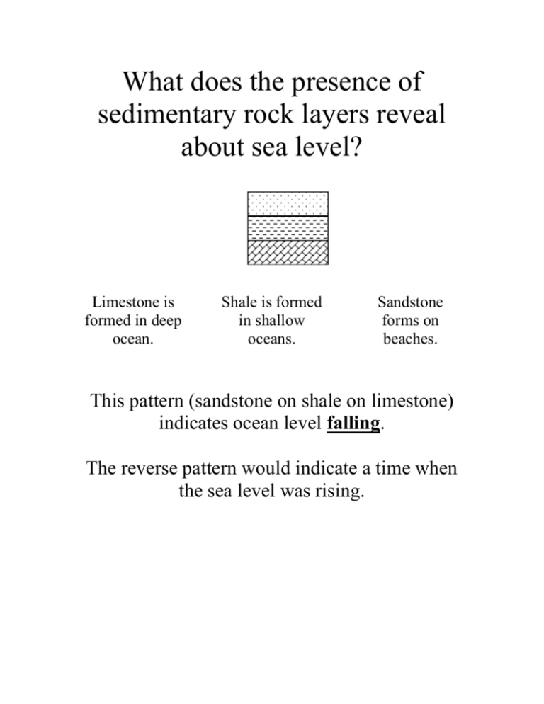
What does the presence of sedimentary rock layers reveal about sea level? Limestone is formed in deep ocean. Shale is formed in shallow oceans. Sandstone forms on beaches. This pattern (sandstone on shale on limestone) indicates ocean level falling. The reverse pattern would indicate a time when the sea level was rising. The top of Mt. Everest is made of limestone. What does this indicate about how the topography of this region has changed? Limestone is formed at the bottom of the ocean. The highest point on Earth was once at the bottom of the ocean! How does the wind cause surface currents in the ocean? By friction of the wind on the upper surface of the ocean (called “wind stress”). If a wind passes from west to east—it causes a surface current from west to east as well. (Ekman drift causes sub-surface currents to bend to the right in the northern hemisphere) In your own words, describe the difference between an intrusive igneous rock and an extrusive igneous rock. Extrusive igneous rocks cool from lava on the surface of the Earth… …while intrusive igneous rocks cool from magma below the surface of the Earth Why are some metamorphic rocks foliated but others lack foliation? Foliation occurs when rocks are exposed to steady pressure. The foliation forms at right angles to the pressure. Without this steady pressure… no foliation! Did the igneous rocks in your community or area form underground or at the Earth’s surface? Explain. Underground. The igneous rocks in this are usually granite. The large crystals indicate that it cooled slowly underground. (There is also rhyolite, a fine textured, pale igneous rock that cooled on the surface) Earth’s orbit has an eccentricity of about 0.017. Compare this value to the ellipse with the lowest eccentricity of those you drew. Why does it make sense to describe Earth’s orbit as "nearly circular"? d=10 cm L=14 cm E=10/14=.71 d=2 cm L=22 cm E=2/22=.091 d=5 Gm L=300 Gm E=5/300=.0167 The ellipses we drew ranged from .71 down to about .091 for the lowest eccentricity. At about .017 eccentricity, Earth’s orbit is far less eccentric, The lower the eccentricity, the more circular the orbit—zero eccentricity is a perfect circle! Rock salt is mined throughout the Great Lakes region. What does this suggest about the past climate of this area? Rock Salt Halite NaCl Rock salt (halite) is formed when seawater evaporates. This area was once under sea level, then sea level fell and the climate warmed enough to evaporate the seawater Explain the relationship between the mineral composition of an igneous rock and the color of the rock. Sandstone has lots of quartz Basalt has lots of biotite and hornblende The lighter colored the minerals are, the lighter colored the rock is. Pale minerals include quartz, feldspar, muscovite and halite. Dark minerals include biotite, hornblende and graphite Why is the mineral composition of a metamorphic rock usually different from the mineral composition of the protolith (the original rock)? Coal forms diamond During metamorphism, the heat and pressure allow chemical reactions that change one mineral into another. The atoms can re-combine into new compounds and the structure of the crystals can be changed as well. Has there been more than one period of metamorphism in this area? Why is the shape of metamorphic rock units usually much more complicated than that of igneous or sedimentary rock units? What is the difference between a sill, a dike, and a batholith? What kinds of rocks are laid down in nearly horizontal layers? Describe tension, compression, and shear forces in your own words. You may wish to use a diagram. What factors determine whether a rock will fault or fold? Define and explain two of the major principles used by geologists to interpret the rock record. (The fault is younger than all of the rocks except the top layer) Youngest Youngest Oldest The principle of superposition says that, since rock layers are usually laid down on top of existing rocks, the layers on top are younger than the layers below. The principle of crosscutting relationships states that if one feature cuts through another, the first feature is younger. The feature that got cut must have been formed first. Why does the horizontal scale of a Mercator projection increase with latitude? When you project the surface of a sphere onto a cylinder, the Equator is right against the cylinder. The polar regions are projected farther away, so they get magnified. A line across the map represents a circle around that part of the globe. The globe gets smaller as you go away from the Equator, but the map is a rectangle. The shorter circle is stretched out to fill the width of the map. Where on Earth do most volcanoes occur? Explain your answer. Most volcanoes occur at plate boundaries. Of plate boundaries, the best ones for volcanoes are convergent ocean continent boundaries. The longest convergent oceancontinent plate boundaries make the Ring of Fire around the north Pacific. Over half of the world’s volcanoes are on the Ring of Fire. Explain in your own words the meaning of a contour line, contour interval, relief, and topographic map. Why do silica-poor magmas produce broad volcanoes with gentle slopes while high-silica magma tends to form volcanic domes with steep sides? Sketch a contour map of a volcano that shows: a gentle slope, a steep slope, a nearly vertical cliff, and a crater or depression at the top For a cinder cone and a shield volcano, sketch a topographic map to show what the volcano would look like from above. Name two factors that influence the viscosity of a lava flow. Describe two ways in which lava flows can be controlled Explain how topography influences volcanic flows. How does the volume of an eruption affect the area covered? Why might a lahar (mudflow of volcanic debris and water) affect a community more severely than a lava flow? Name two factors that can affect the distance that volcanic ash can travel How does the silica content of magma affect how explosive a volcano can be? In your own words, compare the sizes of the areas affected by lava, pyroclastic flows, and ash falls. Why do the eruptions in Hawaii differ from Mt. St. Helens eruption? Do volcanic eruptions increase or decrease the temperature of the Earth? Can monitoring equipment be used to prevent a volcano from erupting? In your answer explain what monitoring equipment can do. No. If a volcano is going to erupt, it is going to erupt. We can’t do anything about it. What we can do is: 1. Get people to safety and 2. Save some of their belongings Not much else. The monitoring equipment will (might!) give us an early warning to save more lives. Describe three methods of monitoring an active volcano. Which monitoring system is a) least reliable, b) most dangerous, and c) most useful? Consider what you know about volcanic hazards. Why is it important to study rocks in your area? Name the three types of boundaries between lithospheric plates. Convergent plate boundaries can be in three different settings. What are they? Convergent means “coming together.” Ocean-Ocean Ocean-Continent Continent-Continent There are two different types of crust: continental crust and ocean-floor crust. Ocean-floor crust is thinner, but denser. The three settings differ by which types come together. Identify on a world map of lithospheric plates one example of each of the following settings: an established divergent boundary an ocean-ocean convergent boundary an ocean-continent convergent boundary a continent-continent collision zone a transform plate boundary How does the density of the Earth provide evidence that the interior of the Earth is denser than the surface? How are convection currents set up? What geographic features would you expect to see at plate boundaries? After reviewing your work with earthquakes and volcanoes, summarize where most earthquakes are located compared to plate boundaries. Although most earthquakes and volcanoes are associated with plate boundaries, they are not always located directly along the boundaries. Considering boundaries between oceanic and continental plates: Why are volcanoes usually found on the continental side of a plate boundary? Make a list of the various plate tectonic settings where mountain ranges are likely to be produced. For each item, draw a cross-section that shows the mountain range and how it relates to the plate-tectonics setting. Then give an example from somewhere in the world for each item. What evidence did Wegener use to support his theory of the breakup of Pangea? How was fossil evidence used to reconstruct Pangea? What is the relationship between the focus and the epicenter of an earthquake? Focus (on the surface) Epicenter (underground ) The epicenter is the spot on the surface above the focus. The focus is where the earthquake really happens, usually far underground. The epicenter is shown on a map. The focus can be shown on a cross-section drawing of that part of the Earth’s crust Use a diagram to describe the difference between: P waves, S waves and Surface waves. Of the types of earthquakes waves discussed, which do you think are the most dangerous? Why? What information is provided by a travel-time curve? What advantages would be gained by having more seismometers at a particular location? Why do scientists use the distribution of earthquakes as evidence to support the theory of plate tectonics? Why is the intensity value of an earthquake more meaningful than magnitude to a non scientist? What geological conditions influence the intensity of an earthquake? What are the direct hazards of an earthquake? In a major earthquake, where in the your school and in your community would you be the safest? What places pose the greatest risk form the effects of an earthquake? Explain why you selected these locations. Name five factors that affect the amount of damage caused by an earthquake. Chapter 5—Water Resources Draw a sketch to show the major processes and reservoirs in the water cycle Describe three “paths” of the water cycle that precipitation can follow once it reaches the surface of the Earth. How can the destruction of large areas of rain forest affect climate? Identify and describe ways that human activity affects surface water and ground water quality. How does the quality of water from local streams, ponds, or untreated wells compare to water that has been processed by a local water treatment plant? Where do you think geese poop? Even a beautiful, peaceful pond harbors an incredible number of organisms that you don’t want inside of you. Don’t drink the untreated water. Really. The treatment removes sediments and kills bacteria and parasites. Drinking untreated water is very dangerous! Chapter 6—Energy Resources What type of electricity generation is used most by the world’s richest countries? Which is used least? What type of electricity generation is used most by the world’s poorest countries? Which is used least? Rank United States electricity generation by fuel type from highest to lowest. How does this ranking match global electricity generation? From an Earth systems perspective, what are the advantages and disadvantages of hydroelectric power? Why are biomass and wind are called renewable energy sources? What are the major factors that determine whether a coal seam is economically and geologically suitable for mining? Think about regional differences in electricity use. Which part of the country do you think would be the lowest? the highest? What are some of the positive impacts associated with the use of energy resources? We call it “quality of life.” The good things in life—heat in the winter, safe water and food, lights after sunset, shelter, transportation, and many others all require energy. If we don’t use the resources we have, we can’t keep all of these things. Even cavemen burned wood to make their campfires! What are some of the negative impacts associated with the use of energy resources? What are the advantages of petroleum and natural gas as fuels? Why are oil and gas considered nonrenewable resources? Is the future decrease in petroleum production likely to be abrupt or gradual? Why? How does the average daily solar radiation per month for January compare with that of July? How might you explain the difference? Why must solar energy systems occupy a much larger area, per unit of energy produced, than conventional systems that burn fossil fuels? Chapter 7—There is no chapter 7—I miscounted. Which of the units in Question 1 (light year, an astronomical unit, and a parsec) would you use to describe each of the following? Justify your choice. Distances to various stars (but not our Sun)? Distances to various planets within our solar system? Widths of galaxies? In your own words, explain the nebular theory for the beginning of our solar system. Observe how the illuminated portion of the Moon changes shape as you turn 45° each time. How would the Moon phases appear from Earth if the Moon rotated in the opposite direction? Summarize your ideas about how the Moon affects the tides. How did the Moon likely form? Describe the relative positions of the Earth, the Moon, and the Sun for a spring tide and for a neap tide. The questions below refer to your investigation of lunar phases. Explain why the Moon looks different in the sky during different times of the month. For an ellipse with a major axis of 25 cm, which one is more eccentric; the one with a distance between the foci of 15 cm or with a distance between the foci of 20 cm? Explain. Why might Neptune be farther away from the Sun at times than Pluto is? What are some of the problems caused by sunspots and solar flares? Static on your radio or phone. Sunspots are a symptom of a magnetic disturbance. Solar flares usually occur when there are a lot of sunspots. The solar flares make a lot of radio “noise.” The solar wind can even short out electrical equipment on satellites…even on the Earth’s surface! In your own words, explain what is meant by the term "solar wind." How does the Sun contribute to "space weather?" Which wavelengths of light can be more harmful to you than others? Why? Explain the relationships between temperature, luminosity, mass, and lifetime of stars. How does the wind cause surface currents in the ocean? Describe the Coriolis effect in your own words. What are the two factors that determine the density of a water mass? Why do individual water masses within the oceans retain distinctive physical properties for long periods of time? Identify and describe the factors that influence surface and deep ocean circulation under El Niño conditions: Are the surface water temperatures along the eastern boundary of the equatorial Pacific Ocean warmer or colder during an El Niño event? Why? What happens to the location of the warm surface water during El Niño? Warmer. The change in wind patterns force the warmer surface water to the east during an El Niño event. Usually, it is forced west, and cooler deep water wells up from below in the east (against the west coast of South America). Ski areas in many parts of the country depend on snowfall. a) In which areas of the country would the ski industry be hit hardest from an El Niño like that of 1982–83? b) Which ski industry would have benefited from the 1982–83El Niño? Do you see a cyclic or predictable trend to the fish-catch data such that you might be able to predict the next El Niño event? If so, what is your prediction? Chapter 10 Draw a diagram that shows how an updraft forms due to: Convection. Orographic uplift. Describe how an approaching cold front can promote the development of thunderstorms. In the central and eastern parts of the United States, what accounts for the general increase in thunderstorms as you go south? On a warm summer afternoon, why might you see scattered cumulus clouds? In other words, why might a cumulus cloud form in one place and not another? Describe what happens to the temperature of a gas when the volume of the gas increases. Warm Cool As the volume increases the gas cools! Describe what happens to the temperature of a gas when the gas is compressed. Cool Warm As you compress a gas, it heats up! Describe the vertical motion of air in a thunderstorm that has reached its mature stage. On a piece of paper, draw the vertical profile of a prominent mountain range. Assume that a humid wind blowing from left to right encounters the mountain range. Because the wind cannot go through rock, it is forced to go up and over the mountain range. Using a broad smooth arrow, draw the wind flowing up the mountain on one side and down the mountain on the other. In pencil, sketch clouds on the side of the mountain where you think clouds and thunderstorms are most likely to form.
