Area archeologica di Roselle
advertisement
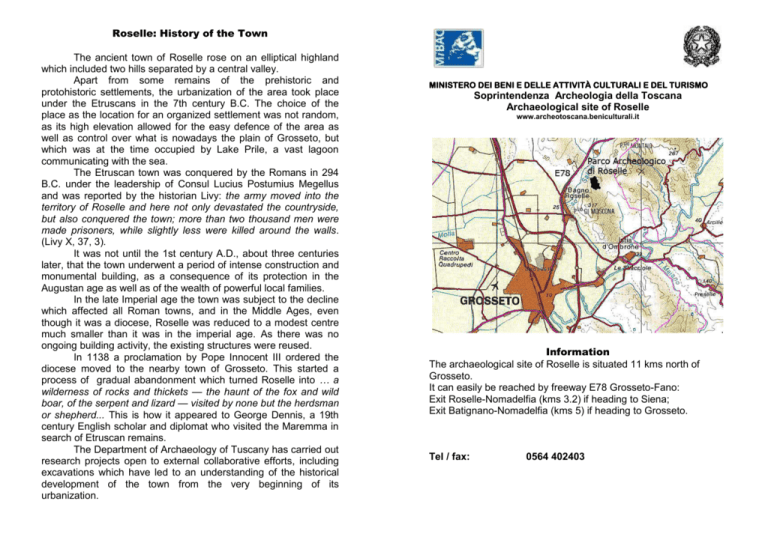
Roselle: History of the Town The ancient town of Roselle rose on an elliptical highland which included two hills separated by a central valley. Apart from some remains of the prehistoric and protohistoric settlements, the urbanization of the area took place under the Etruscans in the 7th century B.C. The choice of the place as the location for an organized settlement was not random, as its high elevation allowed for the easy defence of the area as well as control over what is nowadays the plain of Grosseto, but which was at the time occupied by Lake Prile, a vast lagoon communicating with the sea. The Etruscan town was conquered by the Romans in 294 B.C. under the leadership of Consul Lucius Postumius Megellus and was reported by the historian Livy: the army moved into the territory of Roselle and here not only devastated the countryside, but also conquered the town; more than two thousand men were made prisoners, while slightly less were killed around the walls. (Livy X, 37, 3). It was not until the 1st century A.D., about three centuries later, that the town underwent a period of intense construction and monumental building, as a consequence of its protection in the Augustan age as well as of the wealth of powerful local families. In the late Imperial age the town was subject to the decline which affected all Roman towns, and in the Middle Ages, even though it was a diocese, Roselle was reduced to a modest centre much smaller than it was in the imperial age. As there was no ongoing building activity, the existing structures were reused. In 1138 a proclamation by Pope Innocent III ordered the diocese moved to the nearby town of Grosseto. This started a process of gradual abandonment which turned Roselle into … a wilderness of rocks and thickets — the haunt of the fox and wild boar, of the serpent and lizard — visited by none but the herdsman or shepherd... This is how it appeared to George Dennis, a 19th century English scholar and diplomat who visited the Maremma in search of Etruscan remains. The Department of Archaeology of Tuscany has carried out research projects open to external collaborative efforts, including excavations which have led to an understanding of the historical development of the town from the very beginning of its urbanization. MINISTERO DEI BENI E DELLE ATTIVITÀ CULTURALI E DEL TURISMO Soprintendenza Archeologia della Toscana Archaeological site of Roselle www.archeotoscana.beniculturali.it Information The archaeological site of Roselle is situated 11 kms north of Grosseto. It can easily be reached by freeway E78 Grosseto-Fano: Exit Roselle-Nomadelfia (kms 3.2) if heading to Siena; Exit Batignano-Nomadelfia (kms 5) if heading to Grosseto. Tel / fax: 0564 402403 1. NECROPOLIS OF SERPAIO (6th century B.C. – also used later). The tombs consist of small hypogea with rectangular chambers, entrance passageway, roof with projecting slabs covered by a mound. It also includes a tomb with a mound and rectangular cist for the burial chamber. SITE TOUR FORUM AREA 2. ARZYGIUS’S BATHS (4th century A.D.)The building was used as a public bath. An inscription testifies to its inauguration by Betitius Perpetuus Arzygius, governor of Tuscia and Umbria from 366 to 370 A.D. 3. DECUMANUS MAXIMUS (1st century A.D.) This is one of the town’s two major roads, running east to west. It starts from one of the town gates and connects it to the Forum. Fountains and buildings stood all along the roadside, as shown by the thresholds indicating their entrances. DETAIL OF FORUM AREA SOUTH HILL 4. HADRIAN’S BATHS (120 A.D.). They were built during the reign of Emperor Hadrian. Shaped like an L, they are characterised by the presence of a pool (natatio) NORTH HILL ENTRANCE 5. CHURCH (6th – early 9th century A.D.). In the early Middle Ages a church was erected on the remains of Hadrian’s Baths, using the preexisting structures. A terraced graveyard was outside. NECROPOLIS OF SERPAIO 6. WORKSHOPS (1st century A.D.).A few premises line the Decumanus. Their commercial use (tabernae) can be deduced by the presence of rectangular shelves where the goods were stored. 7. ETRUSCAN BUILDINGS IN THE FORUM AREA (7th-6th century B.C.). The oldest Etruscan buildings can be seen below the pavement of the Roman forum: the so-called “building with enclosure”, comprising a single room with two enclosures, probably a place of worship, as well as another construction known as the “two-roomed building” with two rectangular rooms, which had a public function. 8. FORUM (1st century B.C.). This was the main square of the Roman town, the political, religious and commercial heart of the community. It was fronted by public buildings and temples honouring gods and emperors. 9. CARDO MAXIMUS (1st century B.C.): The eastern side of the Forum is delimited by a road paved with basalt flagstones: the Cardo Maximus, which is the other main road in the town, running north to south. On its surface the marks left by cart wheels are visible. 10. BASILICA (1st century B.C.). This was one of the centres of a public life in the Roman age. It had a rectangular plan with interior colonnade, of which only one plinth is extant. A raised dais (tribunal) was the area reserved for judicial magistrates. 11. NORTHERN SIDE OF THE FORUM (1st century B.C.). In this area are a few buildings which include the Curia, where public meetings were held, as well as the Basilica dei Bassi, home to a set of statues representing the different members of the same family, the Bassi. The building was meant to celebrate this powerful local clan. An Etruscan temple, of which only a few remains are extant, is still visible in the front area. . 12. SOUTHERN SIDE OF THE FORUM (1st century B.C.). The square provides access to the seat of the Flamines Augustales, the priests in charge of the imperial cult. The building housed a series of statues devoted to the imperial Julio-Claudian family. Beside it is the basement of a small temple dedicated to Divus Augustus. 15. CRAFT DISTRICT(6th-5th century B.C.) and RESIDENTIAL DISTRICT (3rd -2nd century B.C.). A craft district was located on the south side of the hill in the Archaic age: a few pottery ovens are still visible. In the Roman age the hill was occupied by houses built along a pebbled road. 16. AMPHITHEATRE (1st century A.D.). It has the typical elliptical shape which characterizes this type of building. The central arena, where spectacles were held, was surrounded by tiers of seats for the public. 17.HELLENISTIC HOUSE (3rd-2nd century B.C.). Near one of the amphitheatre entrances are the remains of a house with a central courtyard (atrium) around which the rest of the rooms are distributed. 13. DOMUS DEI MOSAICI (Mosaic House) (1st century B.C.). It is an example of a Roman house of the atrium type, with a central courtyard and a pool to collect rainwater. The southern end housed baths with mosaic flooring. A columned courtyard (peristyle) overlooked the valley on the west side. 18.IMPLUVIUM HOUSE (6th century B.C.).The Etruscan building has a quadrangular plan. The central part is occupied by a courtyard with a pool for collecting rainwater 14. CISTERN (Roman Imperial Age). Used to collect rainwater, it is coated with lime mortar to waterproof the walls. 19. TOWN WALLS (6th century B.C.). The walls circle the two hillsides. The outer masonry is made of large stones. A number of gates opened along the walls, but only a few have been brought to light.


