09 Module 7 - Geology Information
advertisement
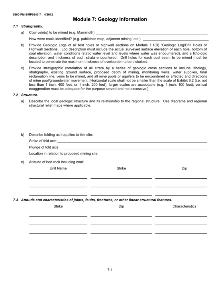
5600-PM-BMP0343-7 4/2012 Module 7: Geology Information 7.1 Stratigraphy. a) Coal vein(s) to be mined (e.g. Mammoth) How were coals identified? (e.g. published map, adjacent mining, etc.) b) Provide Geologic Logs of all test holes or highwall sections on Module 7.1(B) "Geologic Log/Drill Holes or Highwall Sections'. Log description must include the actual surveyed surface elevation of each hole, bottom of coal elevation, water conditions (static water level and levels where water was encountered), and a lithologic description and thickness of each strata encountered. Drill holes for each coal seam to be mined must be located to penetrate the maximum thickness of overburden to be disturbed. c) Provide stratigraphic correlation of all strata by a series of geologic cross sections to include lithology, stratigraphy, existing ground surface, proposed depth of mining, monitoring wells, water supplies, final reclamation line, veins to be mined, and all mine pools or aquifers to be encountered or affected and directions of mine pool/groundwater movement. [Horizontal scale shall not be smaller than the scale of Exhibit 6.2 (i.e. not less than 1 inch: 400 feet, or 1 inch: 200 feet), larger scales are acceptable (e.g. 1 inch: 100 feet); vertical exaggeration must be adequate for the purpose served and not excessive.] 7.2 Structure. a) Describe the local geologic structure and its relationship to the regional structure. Use diagrams and regional structural relief maps where applicable. b) Describe folding as it applies to this site: Strike of fold axis Plunge of fold axis Location in relation to proposed mining site: c) Attitude of bed rock including coal: Unit Name Strike Dip 7.3 Attitude and characteristics of joints, faults, fractures, or other linear structural features. Strike Dip 7-1 Characteristics 5600-PM-BMP0343-7 4/2012 7.1(B) GEOLOGIC LOG/DRILL HOLES or HIGHWALL SECTIONS Hole No.: Surface Elevation: Bottom of Coal Elevations: Groundwater Elevations: and Date Measured Surveyed by: Remarks: Depth Thickness Method: Scale Graphic Log Operation Name: Method of Drilling: Date Drilled: Drilled By: Logged By: Township: County: Quadrangle: Laboratory: UTM’s zone Latitude: STRATA Name and Description 7-2 Northing Page 1 of Easting: Longitude: Water Conditions and Comments or 5600-PM-BMP0343-7 4/2012 7.1(B) GEOLOGIC LOG/DRILL HOLES or HIGHWALL SECTIONS (Continued) Hole No.: Surface Elevation: Page of Operation Name: Township: County: Remarks: Depth Thickness Scale Graphic Log STRATA Name and Description 7-3 Water Conditions and Comments 5600-PM-BMP0343-7 4/2012 7.4 Overburden Analysis. a) Request for Waiver of Overburden Analysis Yes No If yes, include a narrative explanation and documentation supporting the basis for the waiver. b) Typically the Department will grant waivers if the proposed permit area meets any of the following criteria. 1) there is previous mining history in the watershed or adjacent areas documenting associated postmining water quality. 2) lies outside area draining to a High Quality, Exceptional Value, Wilderness Trout Stream or other stream sensitive to mining impact. 3) is not in close proximity to a public water supply. 4) there is no indication of acid or elevated metals from the same coal vein(s) on adjacent mines. 5) removal of alkaline material is not proposed. Note: Prior to initiation of any overburden analysis, contact the Pottsville District Mining Office concerning the submission. 7.5 Mine Workings Submit the following data on all active, completed and abandoned underground and surface mines and coal refuse disposal sites which are in or within l000 feet of the permit area. If all of this data is shown on Exhibits 6.2 (or 6.1), 9 and 18, it does not have to be provided in this Module. (Key location to and show permit boundary on Exhibits 6.2, 9 and 18.) Surface Mines Operator Map Key Status* Coal Vein(s) Underground Mines Map Key Operator Coal Refuse Disposal Sites Operator Status* Coal Vein(s) Portal(s) Elev. Map Key Mine Pool Elev. Type of Seal Status 7.6 Solid Waste Disposal Sites Submit the following data for all active, completed and abandoned waste disposal sites which are in or within 1,000 feet of the permit area: (Key location to and show permit boundary on Exhibits 6.2, 9, and 18.) Operator Permit No. Map Key Status* Type of Waste Disposal *Identify as Active (AC), Completed (C) including year completed, or Abandoned (Ab). 7-4 Water Sample No.(s)
