Location, Geography and Climate of Afghanistan and Tajikistan
advertisement
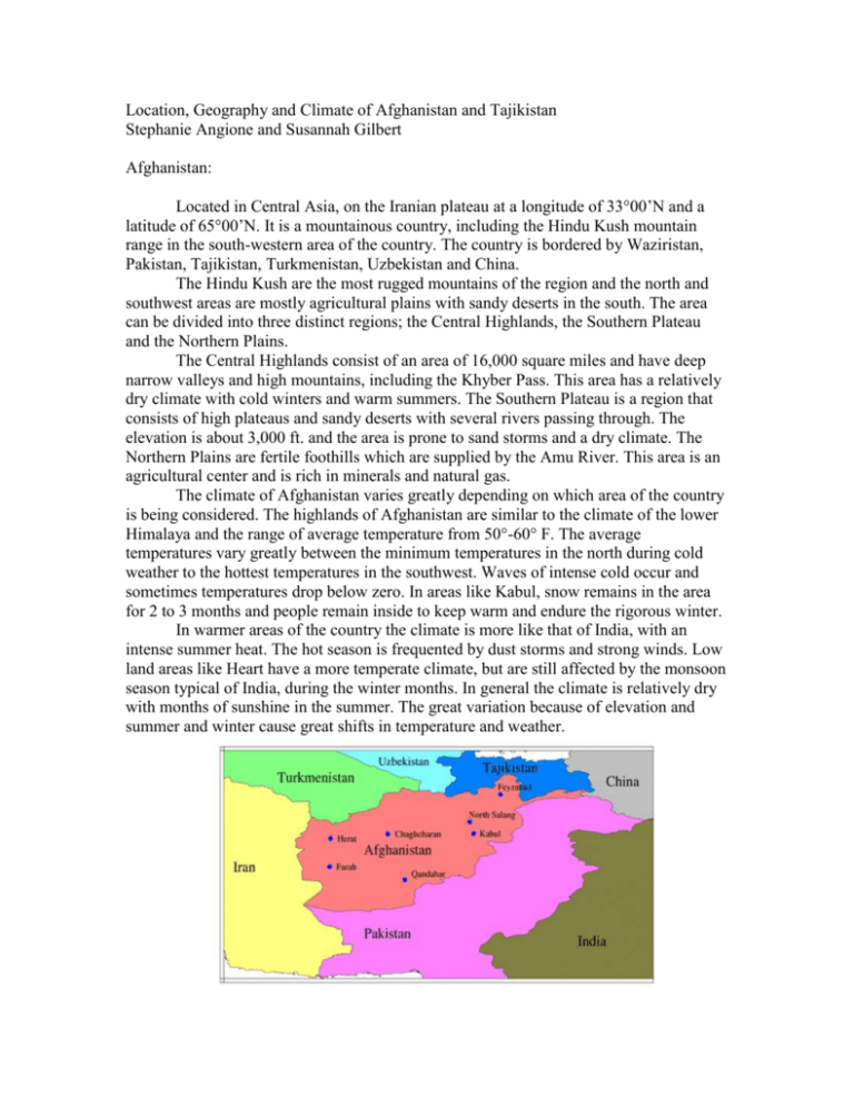
Location, Geography and Climate of Afghanistan and Tajikistan Stephanie Angione and Susannah Gilbert Afghanistan: Located in Central Asia, on the Iranian plateau at a longitude of 33°00’N and a latitude of 65°00’N. It is a mountainous country, including the Hindu Kush mountain range in the south-western area of the country. The country is bordered by Waziristan, Pakistan, Tajikistan, Turkmenistan, Uzbekistan and China. The Hindu Kush are the most rugged mountains of the region and the north and southwest areas are mostly agricultural plains with sandy deserts in the south. The area can be divided into three distinct regions; the Central Highlands, the Southern Plateau and the Northern Plains. The Central Highlands consist of an area of 16,000 square miles and have deep narrow valleys and high mountains, including the Khyber Pass. This area has a relatively dry climate with cold winters and warm summers. The Southern Plateau is a region that consists of high plateaus and sandy deserts with several rivers passing through. The elevation is about 3,000 ft. and the area is prone to sand storms and a dry climate. The Northern Plains are fertile foothills which are supplied by the Amu River. This area is an agricultural center and is rich in minerals and natural gas. The climate of Afghanistan varies greatly depending on which area of the country is being considered. The highlands of Afghanistan are similar to the climate of the lower Himalaya and the range of average temperature from 50°-60° F. The average temperatures vary greatly between the minimum temperatures in the north during cold weather to the hottest temperatures in the southwest. Waves of intense cold occur and sometimes temperatures drop below zero. In areas like Kabul, snow remains in the area for 2 to 3 months and people remain inside to keep warm and endure the rigorous winter. In warmer areas of the country the climate is more like that of India, with an intense summer heat. The hot season is frequented by dust storms and strong winds. Low land areas like Heart have a more temperate climate, but are still affected by the monsoon season typical of India, during the winter months. In general the climate is relatively dry with months of sunshine in the summer. The great variation because of elevation and summer and winter cause great shifts in temperature and weather. Tabulated Monthly Data: mean temp range (°F) January February March April May June July August September October November December 13-45 15-50 22-60 32-71 37-81 46-90 49-94 47-89 40-80 33-68 25-55 18-48 mean minimum temp range (°F) -2-34 4-38 17-47 26-57 31-64 38-73 42-77 40-72 33-63 27-51 19-40 27-51 record mean minimum hours of temp (°F) sunlight snowfall days* rain days -47+ -51+ -18 3 12 19 31 27 16 4 -3+ -31+ 0-13 0-15 0-18 0-15 0-10 0-1 0 0 0-1 0-6 0-8 0-11 0-6 0-8 1-11 3-14 1-12 0-4 0-2 0-1 0-1 0-4 1-4 0-5 113-200 106-198 128-236 155-255 215-346 270-384 288-389 277-358 227-345 184-264 149-264 119-216 Data for record minimum temperature was recorded at the North Salang station except for values followed by a +, which were collected at Chaghcharan. * all highest snowfall values were collected at the North Salang station, and lowest values (0) were collected in the southwest. The stations which collected data include: Feyzabad, elev. 3937 ft. 6 North Salang, elev. 11043 ft Kabul, elev. 5876 ft Chaghcharan, elev. 7162 ft Qandahar, elev. 3314 ft Herat, elev. 3163 ft Farah, elev. 2297 ft Tajikistan: Tajikistan is another Central Asian country, located between Kyrgyzstan, Uzbekistan, China and north of Afghanistan. 93 % of the country is covered in mountains, including the Pamir and Alay ranges which have glacier fed streams and rivers which are used for irrigation. The Tian Shan Mountains in northern Tajikistan separate the populous areas in the lowlands of the south and north. More than half of Tajikistan is above an elevation of 3,000 meters and the lowlands of the Fergana Valley are significantly above sea-level. The highest elevations of the range are on the Kyrgyzstan border and the Fergana Valley is the most densely populated region in Central Asia which spreads across Tajikistan from Uzbekistan to Kyrgyzstan. Tajikistan has dense river network including the Syrdariva and the Zarafshon, which stretches across the Valley. Other lakes and rivers are glacier fed and reach high levels during the spring due to the rainy season and in the summer. The climate of the region ranges from continental, subtropical and semi-arid, with some desert areas. Like Afghanistan, the climate changes greatly with increasing elevation. The lowlands are not subject to the Artic air that influences the mountainous regions, but the temperatures still drop below freezing for more than 100 days a year. In the lowlands, the climate is arid with average temperatures ranging from 23° to 30° in July and -1° to 3° in January. The Eastern mountainous regions have colder temperatures, with 5° to 10° C in July and -15° to -20° C in January. Precipitation averages are from 700 to 1600 mm and the heaviest precipitation in near the Fedchenko Glacier, and lightest in the Pamirs. The winter and spring are generally the rainy and snowy seasons.

