dry-datasharingformat_2006
advertisement
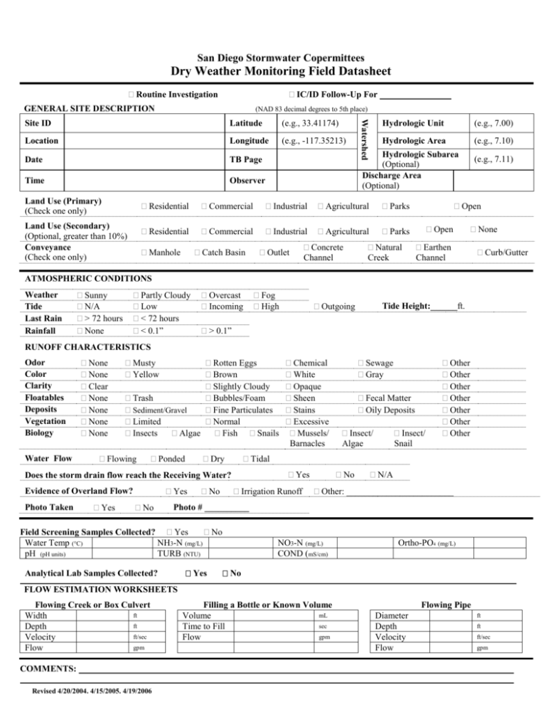
San Diego Stormwater Copermittees Dry Weather Monitoring Field Datasheet Routine Investigation IC/ID Follow-Up For ________________ GENERAL SITE DESCRIPTION (NAD 83 decimal degrees to 5th place) Latitude (e.g., 33.41174) Location Longitude (e.g., -117.35213) Date TB Page Time Observer Watershed Site ID Hydrologic Unit (e.g., 7.00) Hydrologic Area (e.g., 7.10) Hydrologic Subarea (Optional) Discharge Area (Optional) Land Use (Primary) (Check one only) Residential Commercial Industrial Agricultural Parks Land Use (Secondary) (Optional, greater than 10%) Conveyance (Check one only) Residential Commercial Industrial Agricultural Parks Manhole Catch Basin Outlet Concrete Channel Natural Creek (e.g., 7.11) Open Open None Earthen Channel Curb/Gutter ATMOSPHERIC CONDITIONS Weather Tide Last Rain Rainfall Sunny N/A > 72 hours None Partly Cloudy Low < 72 hours < 0.1” Overcast Incoming Fog High Outgoing Tide Height:______ft. > 0.1” RUNOFF CHARACTERISTICS Odor Color Clarity Floatables Deposits Vegetation Biology Water Flow None None Clear None None None None Musty Yellow Rotten Eggs Brown Slightly Cloudy Trash Bubbles/Foam Fine Particulates Sediment/Gravel Limited Normal Insects Algae Fish Snails Flowing Ponded Dry Yes Photo Taken Yes No No Sewage Gray Fecal Matter Oily Deposits Insect/ Algae Insect/ Snail Other Other Other Other Other Other Other Tidal Yes Does the storm drain flow reach the Receiving Water? Evidence of Overland Flow? Chemical White Opaque Sheen Stains Excessive Mussels/ Barnacles Irrigation Runoff No N/A Other: ________________________ Photo # __________ Field Screening Samples Collected? Yes No Water Temp (C) NH3-N (mg/L) pH (pH units) TURB (NTU) Analytical Lab Samples Collected? Yes NO3-N (mg/L) COND (mS/cm) Ortho-PO4 (mg/L) No _________________________________________________ FLOW ESTIMATION WORKSHEETS Flowing Creek or Box Culvert ft Width ft Depth ft/sec Velocity gpm Flow COMMENTS: Revised 4/20/2004. 4/15/2005. 4/19/2006 Filling a Bottle or Known Volume mL Volume sec Time to Fill gpm Flow Flowing Pipe Diameter Depth Velocity Flow ft ft ft/sec gpm San Diego Stormwater Copermittees Land Use Types for Dry Weather Monitoring (Adopted by the Dry Weather Monitoring Workgroup, April 20, 2004) 1. Residential Residential (general) Single- and multi-family homes, mobile home parks, etc. Rural residential (For the County of San Diego and other appropriate Copermittees) Single family homes located in rural areas with lot sizes of approximately 1 to 10 acres. Rural residential estates may have small orchards, fields or small storage buildings associated with the residential dwelling unit, etc. 2. Commercial Offices, schools, shopping centers, auto dealerships, government/civic centers, cemeteries, churches, libraries, post offices, fire/police stations, military use, jails, prisons, border patrol holding stations, dormitories, hotels, motels, resorts, and casinos, etc. 3. Agricultural Orchards, vineyards, nurseries, greenhouses, flower fields, dairies, livestock, poultry, equine ranches, row crops and grains, pasture, fallow, etc. 4. Industrial Shipbuilding, airframe, aircraft manufacturing, industrial parks, manufacturing uses such as lumber, furniture, paper, rubber, stone, clay, and glass; auto repair services/recycling centers; warehousing, wholesale trade; mining, sand and gravel extraction, salt evaporation; junkyard, dumps/landfills; auto wrecking/dismantling and recycling centers, etc. 5. Parks Recreation areas and centers, neighborhood parks, wildlife and nature preserves, golf courses, accessible sandy areas along the coast or major water bodies allowing swimming and picnicking, etc. 6. Open Vacant and undeveloped lands, etc. Revised 4/20/2004. 4/15/2005. 4/19/2006
