Groundwater Hazards
advertisement
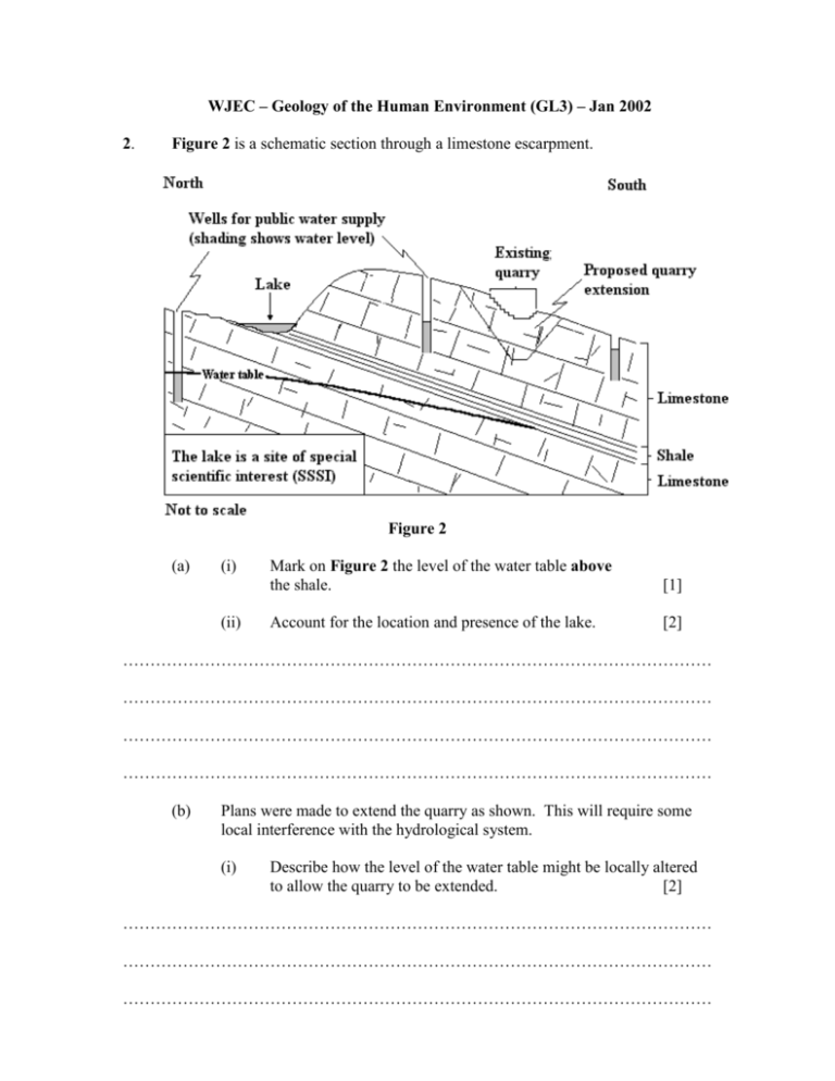
WJEC – Geology of the Human Environment (GL3) – Jan 2002 2. Figure 2 is a schematic section through a limestone escarpment. Figure 2 (a) (i) (ii) Mark on Figure 2 the level of the water table above the shale. [1] Account for the location and presence of the lake. [2] ……………………………………………………………………………………………… ……………………………………………………………………………………………… ……………………………………………………………………………………………… ……………………………………………………………………………………………… (b) Plans were made to extend the quarry as shown. This will require some local interference with the hydrological system. (i) Describe how the level of the water table might be locally altered to allow the quarry to be extended. [2] ……………………………………………………………………………………………… ……………………………………………………………………………………………… ……………………………………………………………………………………………… (ii) Predict the possible consequences of such interference in this area. [3] ……………………………………………………………………………………………… ……………………………………………………………………………………………… ……………………………………………………………………………………………… ……………………………………………………………………………………………… ……………………………………………………………………………………………… (c) Disused quarries are sometimes used as landfill sites for domestic waste. (i) Give a geological explanation of two possible hazards associated with landfill sites. [2] ……………………………………………………………………………………………… ……………………………………………………………………………………………… ……………………………………………………………………………………………… ……………………………………………………………………………………………… (ii) Explain how potential hazards may be overcome by engineering practice. [3] ……………………………………………………………………………………………… ……………………………………………………………………………………………… ……………………………………………………………………………………………… ……………………………………………………………………………………………… ……………………………………………………………………………………………… Total 13 marks Notes for answers These represent suggested answers and do not necessarily represent all the possible acceptable alternatives of a mark scheme. Question 2 (a) (b) (c) (i) Line linking lake level and wells. [1] (ii) Natural depression at base of escarpment Underlain by impermeable shale Water table forced to surface (2 max) [2] (i) Boreholes drilled around quarry (Credit use of existing wells) Over pumping of groundwater (greater than recharge) Creating a cone of exhaustion.( (or drawn/annotated on Figure 2) (other appropriate - e.g. providing sump at bottom of quarry) (2 max) [2] (ii) Lowering of WT may cause wells (springs feeding lake) may dry up lake may disappear/evaporate if WT does not reach surface instability/subsidence owing to reduced pore pressure. other sensible - e.g. extra surface runoff from pumped water (3 max) [3] (i) Accept general answer or specific to Figure 2. One from any TWO of the following: Leachate pollution - as limestone permeable - groundwater flow to water supply (towards the lake (SSSI)) Methane gas production - migrates through permeable rock - methane gas is explosive Subsidence/instability - as waste decomposes and surface collapses (2 max) [2] (ii) Contained site - Impermeable HDP lining Leachate management system Boreholes around to monitor Boreholes to vent methane Sealing top to reduce leachate Cells within to separate/confine reactive materials (3 max) [3] Total 13 marks ESTA would like to thank the WJEC for allowing this question to be published on GEOTREX. Any comments should be directed to the Subject Officer for Geology at the WJEC. 15/04/2007

