Weekly Indicators-Big Ideas Unit 2
advertisement
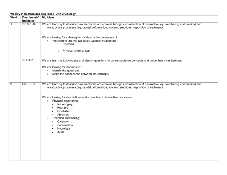
Weekly Indicators and Big Ideas Unit 3 Geology Week Benchmark/ Big Ideas Indicator 1 ES 8-E-13 We are learning to describe how landforms are created through a combination of destructive (eg. weathering and erosion) and constructive processes (eg. crustal deformation, volcanic eruptions, deposition of sediment) We are looking for a description of destructive processes of Weathering and the two basic types of weathering. o Chemical o SI 7-A-3 Physical (mechanical) We are learning to formulate and identify questions to connect science concepts and guide their investigations. We are looking for students to: Identify the questions Make the connections between the concepts 2 ES 8-E-13 We are learning to describe how landforms are created through a combination of destructive (eg. weathering and erosion) and constructive processes (eg. crustal deformation, volcanic eruptions, deposition of sediment) We are looking for descriptions and examples of destructive processes: Physical weathering: Ice wedging Root pry Exfoliation Abrasion Chemical weathering: Oxidation Carbonation Hydrolysis Acids 3 ES- E-13 We are learning to describe how landforms are created through a combination of destructive (eg. weathering and erosion) and constructive processes (eg. crustal deformation, volcanic eruptions, deposition of sediment) We are looking for how these destructive processes of erosion occur: Mass movement. Landslides Mudslides Slump Creep 4 ES E-13 We are learning to describe how the constructive process of deposition of sediment creates landforms. We are looking for how the following are created by deposition of sediment: deltas alluvial fans meanders oxbow lakes 5 ES 8-12 We are learning to explain the processes involved in the rock cycle that are directly related to thermal energy and forces in the mantle that drive plate motion. We are looking for an explanation of the processes in the rock cycle: Heat and pressure create metamorphic rock Melting, cooling and solidifying create igneous rock 6 ES 8-E-14 We are learning to explain how folding, faulting and uplifting contribute to the rearrangement of rock layers. We are looking for an explanation of each of the following and how they contribute to the rearrangement of rock layers. Folding- rocks are rearranged by bending Faulting- rocks are rearranged by movement of faults Uplifting- rocks are rearranged by tectonic activity forcing them upward LS 8-D-4 We are learning to explain that the diversity of species is developed over generations, as shown by the fossil record. We are looking for how the fossil record shows the evolution of life on Earth: Animals which have become extinct Older rocks contain fossils of simpler organisms Younger rocks contain fossils of more complex organisms The activities of ancient animals 7 LS 8-D-5 We are learning to describe how organisms may become extinct if the environment changes as shown by the fossil record. We are looking for how these environmental changes could cause mass extinction: Ice age Tectonic activities Floods 8 ES 8-E-9 We are learning to describe the structure of the Earth’s interior. We are looking for a description of the characteristics of Earth’s interior: Crust, mantle, core Lithosphere, asthenosphere 9 ES-8-E-9 We are learning to describe how the Earth’s crust is divided into tectonic plates which ride on top of the slow moving currents of magma in the mantle. We are looking for how the following evidence supports plate movement (continental drift): Landforms Fossils Climate 10 ES 8-E-15 We are learning to explain how boundaries cause different landforms. We are looking for the landforms created at: Divergent boundaries: Mid-ocean ridges Rift valleys Convergent Boundaries Mountain building Trenches Transform Off-set features 11 ES 8-E-10 We are learning to explain that most geological events result from plate motion. We are looking for a explanation of features on the Earth’s surface created by plate tectonics: Mountain building Volcanic eruptions Hot Spots/Island arcs Faults/Earthquakes 12 SI 7-B-7 We are learning to use graphs, tables and charts. ES 8-E-10 We are looking for use of graphics to study physical features and to make inferences about relationships between variables Density Heat transfer . We are learning to explain that most geological events (volcanic eruptions, mountain building) result from plate motion. We are looking for use of maps to explain the plate movement as it relates to the location of mountain ranges, volcanoes, and rift valleys. 13 We are learning to illustrate how the three type of plate boundaries cause volcanoes (landform). ES 8-E-15 We are looking for a graphic showing how the three types of boundaries create volcanoes: Divergent boundaries Convergent boundaries Transform boundaries
