Nuuk - WMO
advertisement
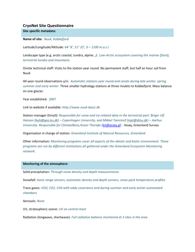
CryoNet Site Questionnaire Site specific metadata: Name of site: Nuuk, Kobbefjord Latitude/Longitude/Altitude: 64° 8’, 51° 22’, 0 – 1100 m.a.s.l. Landscape type (e.g. arctic coastal, tundra, alpine…): Low-Arctic ecosystem covering the marine (fiord), terrestrial tundra and mountains. Onsite technical staff: Visits to the station year round. No permanent staff, but half an hour sail from Nuuk All-year round observations y/n: Automatic stations year round and onsite during late winter, spring, summer and early winter. Three smaller hydrology stations at three rivulets to Kobbefjord. Mass balance on one glacier. Year established: 2007 Link to website if available: http://www.nuuk-basic.dk Station manager (Email): Responsible for snow and ice-related data in the terrestrial part: Birger Ulf Hansen (buh@geo.ku.dk) – Copenhagen University, and Mikkel Tamstorf (mpt@dmu.dk) – Aarhus University. Responsible for ClimateBasis,Kisser Thorsøe (kit@asiaq.gl) - Asiaq, Greenland Survey Organisation in charge of station: Greenland Institute of Natural Resources, Greenland Other information: Monitoring programs cover all aspects of the abiotic and biotic environment. These programs are run by different institutions all gathered under the Greenland Ecosystem Monitoring network. Monitoring of the atmosphere: Solid precipitation: Through snow density and depth measurements Snowfall: Sonic range sensors, automatic density and depth sensors, snow pack temperature profiles Trace gases: H2O, CO2, CH4 with eddy covariance and during summer and early winter automated chambers Aerosols: None UV, stratospheric ozone: UV on central mast Radiation (longwave, shortwave): Full radiation balance monitored at 3 sites in the area Others: Full energy balance at several stations in the area including sensible and latent heat fluxes year round. Snow cover Physical parameters: Depth, density, layering, cover (point and distributed) Chemical parameters: Others: Snow distribution through use of automatic cameras, satellite products and modelling (SnowModel). Snow depth in transects of 1-3 km by ground penetrating radar (GPR). Glaciers and ice caps Mass balance (measured parameters): accumulation by stakes, measured with RTK Ice flow (measured parameters): by stakes, measured with RTK Basal water pressure (measured parameters): Others: Sea ice Mass balance (measured parameters): Thickness, cover, timing Meteorology: All relevant climate parameters (air temperature, humidity, air pressure, wind speed wind direction, radiation (in- and out, short- and long), PAR, etc. Snow on ice (measured parameters): Ice chemistry (measured parameters): Others: Permafrost Borehole measurements (measured parameters): Only sporadic permafrost Meteorology: Radiation, air temperature, humidity, wind speed and direction, air pressure etc. Snow on ground (measured parameters): Sonic range sensors, Snow Pack Analyzer Active layer thickness (measured parameters): GST: Soil temperature in 1 cm depth Others: Soil surface temperatures, soil heat flux plates Ice sheet Mass balance (measured parameters): Meteorology (measured parameters): Snow on ice (measured parameters): Ice chemistry (measured parameters): Others: Other measurements (hydrological, ecological, oceanographic, etc) Hydrology (measured parameters): River discharge in the main catchment to Kobbefjord all year. A number of manual discharge measurements are made during the melt season. Both are used for calculating the discharge. Furthermore the WL is measured at three rivulets to Kobbefjord during the melt season. A number of manual discharge measurements are made during the seasons. Both are used for calculating the discharge. Ecology (measured parameters): Plants, birds, Arthropods, Mammals, phenology throughout the ecosystem processes. See http://www.nuuk-basic.dk/monitoring Oceanography (measured parameters): sea ice from remote sensing, physical, chemical and biological profiles of the water column and sediments, seabirds and marine mammals. Other thematic linkages: Linkages to satellite data (describe validation programs, applications of satellite data, etc.) 50+ high resolution satellite scenes gathered since 2004 for the area including QuickBird, Formosat, WorldView, Ikonos, ASTER, SPOT, Landsat a.o. Participation in international monitoring programmes such as GAW, GTN-G, GTN-P, …. Networks and start of contribution: International Tundra Experiment (ITEX), The Global Observation Research Initiative in Alpine Environments (GLORIA), Hydrology Data and Information Services Center (HDISC), FluxNet, Circumpolar Biodiversity Mapping Program (CBMP), Svalbard Integrated Arctic Earth Observing System (SIOS), International Network of Terrestrial Research and Monitoring in the Arctic (INTERACT). Most contributions have started in 2007 when the station program was initiated.
