Unit 3 Section 2 Volcanoes Answer Key - WAHS
advertisement
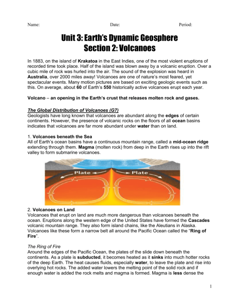
Name: Date: Period: Unit 3: Earth’s Dynamic Geosphere Section 2: Volcanoes In 1883, on the island of Krakatoa in the East Indies, one of the most violent eruptions of recorded time took place. Half of the island was blown away by a volcanic eruption. Over a cubic mile of rock was hurled into the air. The sound of the explosion was heard in Australia, over 2000 miles away! Volcanoes are one of nature’s most feared, yet spectacular events. Many motion pictures are based on exciting geologic events such as this. On average, about 60 of Earth’s 550 historically active volcanoes erupt each year. Volcano – an opening in the Earth’s crust that releases molten rock and gases. The Global Distribution of Volcanoes (G7) Geologists have long known that volcanoes are abundant along the edges of certain continents. However, the presence of volcanic rocks on the floors of all ocean basins indicates that volcanoes are far more abundant under water than on land. 1. Volcanoes beneath the Sea All of Earth’s ocean basins have a continuous mountain range, called a mid-ocean ridge extending through them. Magma (molten rock) from deep in the Earth rises up into the rift valley to form submarine volcanoes. 2. Volcanoes on Land Volcanoes that erupt on land are much more dangerous than volcanoes beneath the ocean. Eruptions along the western edge of the United States have formed the Cascades volcanic mountain range. They also form island chains, like the Aleutians in Alaska. Volcanoes like these form a narrow belt all around the Pacific Ocean called the “Ring of Fire”. The Ring of Fire Around the edges of the Pacific Ocean, the plates of the slide down beneath the continents. As a plate is subducted, it becomes heated as it sinks into much hotter rocks of the deep Earth. The heat causes fluids, especially water, to leave the plate and rise into overlying hot rocks. The added water lowers the melting point of the solid rock and if enough water is added the rock melts and magma is formed. Magma is less dense the 1 rock around it so it rises to the surface forming a volcano. About 80% of all land volcanoes form this way. Volcanoes Formed by Rifting on the Continents When two continents move apart, rift valleys are formed just like under the ocean. The continental plates are stretched and broken during this process. Magma sometimes takes advantage of this weakness in the crust and rises up. Volcanoes at Hot Spots A small percentage of volcanoes occur in the interior of a plate. The Hawaiian Islands are one such example. Only the youngest island has an active volcano. Beneath the ocean there is a fixed source of rising magma called a hot spot. As the Pacific Plate moves northwest, it passes over the fixed hot spot. Magma from the hot spot punches its way through the moving plate to form a chain of islands. Seamounts are submerged mountains that never broke the surface of the water. Map Projections There is always a problem with drawing a map of the world, because you have to try to show the curved surface on a flat sheet of paper. Multiple map projections have been developed to show the Earth’s surface, however, they all have some sort of distortion. The Mercator projection (like the one showed above) becomes more distorted as you move further away from the equator. The larger the area, the less detail we can show so some volcanoes seem to overlap. 2 Define the following terms using your textbook. Magma – Naturally occurring molten rock material generated within the Earth. Lava – Molten rock that issues from a volcano or fissure. Hot Spot – A fixed source of abundant rising magma that forms a volcanic center that has persisted for tens of millions of years. Map Projections – The process of systematically transforming positions on the Earth’s spherical surface to a flat map while maintaining spatial relationships. Mercator Projection – A map projection in which the Equator is represented by a straight line true to scale, and as you move further away from the Equator, more distortion occurs. Seamount – A peaked or flat-topped underwater mountain rising from the ocean floor. Review Questions 1. What evidence do geologists have that volcanoes occur on the ocean floor? _____________________________________________________________________ _____________________________________________________________________ 2. What is the Ring of Fire and where is it located? ___________________________________________________________ ___________________________________________________________ 3. Where do most volcanoes on land form? ___________________________________________________________ ___________________________________________________________ 4. What are hot spots? Provide one example of a hot spot. _____________________________________________________________________ _____________________________________________________________________ 5. What is the problem with flat maps? _____________________________________________________________________ _____________________________________________________________________ 6. Where on Earth do most volcanoes occur? __________________________________ 3 When most people think about volcanoes, they probably have in mind a steep-sided cone. Many volcanoes, however, have very gentle slopes and some look like craters. Topography of Volcanic Regions (G17) Topographic maps have contour lines. These are curves that connect all points at the same elevation. The contour interval is the difference in elevation between adjacent contour lines. A topographic map shows how steep or gentle a slope is. It also shows the elevation and shape of the land. Relief is the difference in elevation between the highest and lowest points on the map. Important Points to Remember when Interpreting Topographic Maps Contour lines never cross, but two or more can run together, where there is a vertical cliff. The closer together the contour lines, the steeper the slope. Contour lines for closed depressions, such as a volcanic crater, are marked with “tick marks” pointing downslope, into the depression. On most topographic maps, every fifth contour line on a map is darker and its elevation is always marked. Magma Composition Volcanoes come in many shapes and sizes. The forces of nature can change the shape of a volcano, both between eruptions and after the volcano becomes dormant. The chemical composition of magma can have an even greater effect on the shape the volcano takes as it forms. Magma is a mixture of liquid, melted rock, and dissolved gasses. The most common elements in magma are silicon and oxygen which together are called silica. As the magma cools it combines with other elements to form silicate minerals. Rock that forms when molten materials become solid are called igneous rock. Magmas that are rich in silica do not flow as easily as magmas that are poor in silica. Therefore, silica-rich magmas are more likely to stay underground at shallow depths, but are more explosive. Dissolved gasses cannot escape slowly, so they continue to build until an explosion becomes necessary to release the pressure. Viscosity – the property of a fluid to offer internal resistance to flow or a measurement of how much a particular substance behaves like a fluid. High viscosity = less fluid, low viscosity = more fluid. Types of Volcanic Landforms 1. Shield Volcanoes – When low-silica magma erupts, lava tends to flow freely and far. It erupts from a single opening (or vent) or closely spaced vents. Creates a gently sloping hill. 4 3. Dome Volcanoes – When silica-rich volcanoes erupt, they ooze slowly like toothpaste squeezed out of a vertical tube. Sometimes the magma doesn’t even make it to the surface. The stiff lava forms volcanic domes with steep slopes. If the volcano’s vent gets plugged, gasses cannot escape and pressure builds. The pressure can be released in a volcanic eruption that blasts pieces of lava and rock into the atmosphere. (pyroclastics) A composite cone forms by many eruptions of material with medium or high-silica content. They erupt violently when pressure builds up in the magma. After the initial explosion, lots of gooey (viscous) lava oozes out of the top. The volcano becomes quiet for a while, but pressure builds and repeats the cycle all over again. 4. Caldera Volcanoes – When a very large volume of magma is erupted, the overlying rock may collapse all around the original vent. The collapse produces a hole or depression at the surface called a caldera. A caldera is much larger that the original vent from which the magma erupted. Sometimes these depressions collect water. Define the following terms using your textbook. Contour Lines – Contour Interval – 5 Topographic Map – Relief – Igneous Rock – Silica – Shield Volcano – Composite Cone – Caldera – Review Questions 1. What is the purpose of a topographic map? _____________________________________________________________________ _____________________________________________________________________ 2. Arrange the following substances from low viscosity to high viscosity: water, syrup, vegetable oil. _____________________________________________________________________ 3. What is the silica content of magma with a low viscosity? (low or high content) _______ 4. Why do silica-poor magmas produce broad volcanoes with gentle slopes? _____________________________________________________________________ _____________________________________________________________________ 5. Why are silica-rich magmas more prone to explosive eruptions? _____________________________________________________________________ _____________________________________________________________________ 6. How is a caldera formed? _____________________________________________________________________ _____________________________________________________________________ 6 Only one person in the entire city of St. Pierre, on Martinique in the Caribbean, survived the hot ash and rock fragments that swept over the city from the explosive eruption of Mt. Pelée in 1902. He was a prisoner in a dungeon deep underground. Over 29,000 people were reported dead. Volcanic Hazards: Flows (G26) Lava flows are streams of molten rock that come from vents and fissures in the Earth’s crust. Lava flows destroy almost everything in their path. Fortunately, most lava flows move slowly enough that people and animals can move out of the way. The speed and overall distance covered by lava is influenced by the steepness of the slope, the viscosity of the lava, and the temperature at which it leaves the volcano. Factors Affecting Speed and Distance of Lava Slope Temperature Silica Content Increase in Factor Decrease in Factor + + - + It is sometimes possible to control the flow of lava. In 1973, lava flows threatened to cut off a vital harbor at Heimaey, Iceland. Citizens sprayed water onto the lava from ships in the harbor and stopped the flow. Lava flows can also be diverted away from populated areas by carving a new channel or pathway through the landscape for the lava to flow. Pyroclastic Flows These types of flows occur in explosive eruptions and are composed of high-density mixtures of hot ash and rock fragments with hot gases. They move away from the vent at speeds of up to 350 km/hr. They often have two parts: a lower flow of coarse fragments and a turbulent cloud of ash rising above. They are very dangerous and destroy everything in their path. Lahar Lahar is a wet mixture of water, mud, and volcanic rock fragments, with the consistency of wet concrete. Lahars often are filled with small rock fragments but can carry huge boulders as well. Heat from eruptions may melt snow and ice, rain may fall, or flows displace water from a mountain river adding water to the ash and other debris which then act like a landslide that can cover whole towns. Volcanic Hazards: Airborne Debris (G31) Tephra is a term for pieces of volcanic rock and lava that are ejected into the air. Particle types according to size: Volcanic Bombs (greater than 64 mm) Lapilli (between 2 and 64 mm) Ash (less than 2 mm) Bombs and lapilli usually fall close to the volcano, but ash can travel hundreds to thousands of kilometers. The height of the ash and the wind speed control how far the ash travels. 7 Ash that falls on homes, factories, and schools can collapse roofs. More than 300 people died after the 1991 eruption of Mt. Pinatubo in the Philippines and most of these deaths were caused by roof failure. At ground level, fine ash causes breathing problems in humans and animals by coating the inside of the lungs and throat and mixing into a cement-like material. It can also damage automobile, truck, and plane engines. Ash that coats the leaves of plants interferes with photosynthesis. Volcanic Explosivity Index The Volcanic Explosivity Index or VEI is based in the volume of erupted material and the height it reaches. This chart can be found on page G35 of your text. The size of the eruption depends on several factors such as the composition of the magma and the amount of gas dissolved in the magma. Just because the volcano is judged to be more explosive does not necessarily mean that it is more dangerous. For example, Tambora was measured to be a very explosive volcano (VEI of 7) and it erupted in 1815 with tephra fall, a tsunami, and pyroclastic flows killing about 10,000 people. Later on, famine from the destroyed crops and shortened growing season killed more than 82,000 people. Define the following terms using your textbook. Lava Flow – Viscosity – Pyroclastic Flow – Lahar – Tephra – Volcanic Bomb – Lapilli – Ash – 8 Review Questions 1. Name the 3 factors that influence the distance and speed of lava flows. ______________________________________ ______________________________________ ______________________________________ 2. Describe two ways in which lava flows can be controlled. _____________________________________________________________________ _____________________________________________________________________ 3. Name two factors that can affect the distance that volcanic ash can flow. ______________________________________ ______________________________________ 4. Why is ash so dangerous to inhale? _____________________________________________________________________ _____________________________________________________________________ 5. What is the number one reason people die from a high amount of tephra fall? _____________________________________________________________________ _____________________________________________________________________ 6. a. On the VEI of the deadliest eruptions since 1500 A.D. on page G36 of your text, which eruption killed the most people? ____________________________ b. Which one was measured to be the most explosive? _________________________ Section 2 Vocabulary ______________________________________________________________________ Mid-Ocean Ridge Rift Valley Magma Hot Spot Map Projections Lava Mercator Projections Seamount ______________________________________________________________________ Contour Lines Contour Interval Topographic Map Relief Igneous Rock Silica Shield Volcano Composite Cone Caldera ______________________________________________________________________ Lava Flow Viscosity Pyroclastic Flow Lahar Tephra Volcanic Bomb Lapilli Ash Volcanic Explosivity Index ______________________________________________________________________ 9
