Compendium Article on Stone Circle
advertisement
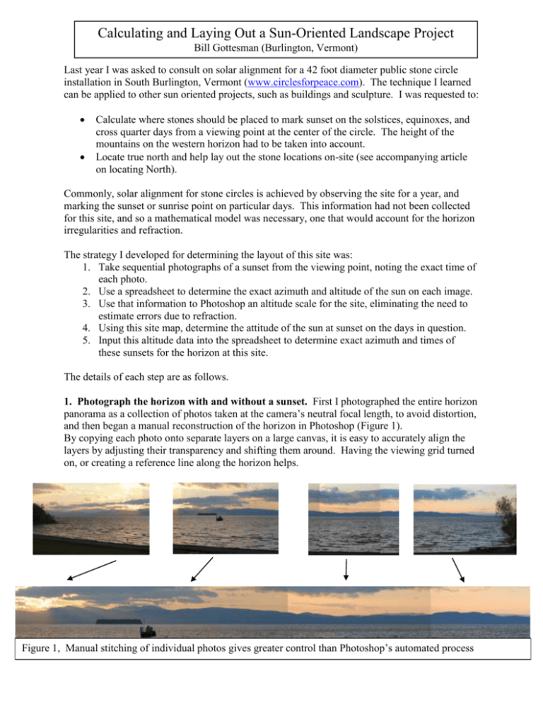
Calculating and Laying Out a Sun-Oriented Landscape Project Bill Gottesman (Burlington, Vermont) Last year I was asked to consult on solar alignment for a 42 foot diameter public stone circle installation in South Burlington, Vermont (www.circlesforpeace.com). The technique I learned can be applied to other sun oriented projects, such as buildings and sculpture. I was requested to: Calculate where stones should be placed to mark sunset on the solstices, equinoxes, and cross quarter days from a viewing point at the center of the circle. The height of the mountains on the western horizon had to be taken into account. Locate true north and help lay out the stone locations on-site (see accompanying article on locating North). Commonly, solar alignment for stone circles is achieved by observing the site for a year, and marking the sunset or sunrise point on particular days. This information had not been collected for this site, and so a mathematical model was necessary, one that would account for the horizon irregularities and refraction. The strategy I developed for determining the layout of this site was: 1. Take sequential photographs of a sunset from the viewing point, noting the exact time of each photo. 2. Use a spreadsheet to determine the exact azimuth and altitude of the sun on each image. 3. Use that information to Photoshop an altitude scale for the site, eliminating the need to estimate errors due to refraction. 4. Using this site map, determine the attitude of the sun at sunset on the days in question. 5. Input this altitude data into the spreadsheet to determine exact azimuth and times of these sunsets for the horizon at this site. The details of each step are as follows. 1. Photograph the horizon with and without a sunset. First I photographed the entire horizon panorama as a collection of photos taken at the camera’s neutral focal length, to avoid distortion, and then began a manual reconstruction of the horizon in Photoshop (Figure 1). By copying each photo onto separate layers on a large canvas, it is easy to accurately align the layers by adjusting their transparency and shifting them around. Having the viewing grid turned on, or creating a reference line along the horizon helps. Figure 1, Manual stitching of individual photos gives greater control than Photoshop’s automated process Next, I superimposed sequential images containing the sun. Using the spreadsheet developed in step 2 below, I labeled the time, azimuth, and altitude of each solar image (figure 2. In this example, only the altitude of the lower sun image is labeled). Figure 2, Superimposed photographs of setting sun on 10/21/2006 2. Develop a spreadsheet. Using formulas from Jean Meuss’ Astronomical Algorithms 2nd edition (©1998, Willman-Bell Inc.) I developed a spreadsheet to calculate azimuth and altitude for any given date and time, AND vice-versa, that is to say the time of any given altitude or Figure 3, Development of reference scales for azimuths and altitudes. azimuth for any given date. This spreadsheet is freely available at www.precisionsundials.com/sunpositioncalculator.xls and also calculates other useful values such as declination, equation of time correction, time of solar noon, conversion between degrees and degrees-minutes-seconds, and times/dates of solstices and equinoxes. It contains instructions, and the hidden calculations are viewable for anyone who is familiar with Excel. From the date and time of the photos, I was able to calculate the exact coordinates of the sun in each photo. Another excellent azimuth calculator is Luke Colleti’s Solar Calculator (http://www.gcstudio.com/suncalc.html) – an advantage being that it can print out a table of azimuths over the course of a day. The NASS Dialist’s Companion can calculate these values as well. 3. Develop and altitude and azimuth scale. In Figure 3, azimuth and altitude scales were developed based on the distances between the known positions of the superimposed suns on the photo. From all my photos, these reference distances amounted to just a few degrees (in Figure 3, the maximum azimuth difference is only 73.48-72.77, or 0.71 degrees), and the scale developed from them is not accurate over long distances (e.g. 30 degrees). In hindsight, I would have used a transit level, or theodolite, on site to measure a larger arc of the horizon as the basis for a reference scale. Alternatively, I could have also taken sunset photos at another date to create a larger reference distance. In the end, I needed a reference scale about 70 degrees wide to predict sunsets from summer to winter solstices. The altitude lines at 1.15, 06.5, and 0.15 degrees covered the range of mountain heights along the horizon, and allowed me to see at what calculated height the sun would set at a given azimuth. 4 & 5. Determine at what altitudes and azimuths the sun will set on key dates. I used the “Solstices & Equinoxes” page of the spreadsheet to determine the general dates of the these events for this time zone for a midleap-year-cycle year, such as 2006. For each date I then used the “Altitude Calc.” page to determine the approximate azimuth of the sun at an altitude of 1 degree, roughly the height of the horizon. I then looked at the horizon photo with the reference scales, and determined how high the horizon is at each azimuth. This was the first part of a two step iterative process. I could then tell what the actual horizon elevation would be at that azimuth, and (Step 5) re-enter this altitude into “Altitude Calc.” page to get the exact azimuth for the date in question, and the iterative process is complete. I then map and label this on the photomontage, and Figure 4, Calculated placement of Equinox suns generate a table of exact coordinates and times of these sunset events for the client. In Figure 4, the equinox suns set at an azimuth of approximately 89 degrees. Looking at the horizon reference, I saw that the sun touched the mountains when the sun’s center was at an altitude of 1.15 degrees. Plugging 1.15 degrees into the “Altitude Calc.” sheet, I determined that the spring equinox sun set at an azimuth of 89.0 degrees, and the fall equinox sun at 88.4 degrees, for the mid-leap-year-cycle. This brings up the question of what to consider “sunset”—Sun touching horizon, sun half set, or sun fully set? For this project I defined sunset as sun touching the horizon, but having now seen the site in action, my future preference will be to use “sun half set” instead. Figure 5 is the final montage created for the site. Figure 5, Final Panorama of real sunset photos 10/212006, along with calculated placement of seasonal suns What happened to refraction? The positions of the sun in the reference photos were of course affected by the atmospheric refraction, but the calculated altitudes did not include an algorithm for refraction. Why? I had assumed that the effect of refraction would be consistent across the small (1 degree) range of sunset altitudes along this horizon, and would not significantly affect predictions of the sun’s position. In hindsight, this was not a fully valid assumption; refraction affects the sun by 1/10 of a degree more at an altitude of 0.5 degrees than at 1.5 degrees. In any future project I intend to include Jean Meeus’s formula for compensation of refraction. Figure 6, Pagan seasonal cross quarter days. Figures 6, 7 and 8 give an overview of the stone circle, and an astronomical explanation of crossquarter-days. Cross quarter days are loosely defined, as best I can tell, and are a pagan construct for marking the middle of the seasons, and not all references agree on the astronomical definition given here. Figures 7 & 8, Layout of 42 foot diameter stone circle, including central analemmatic sundial, and site photo.
