ATSC5160 Homework2 Qing Yang
advertisement
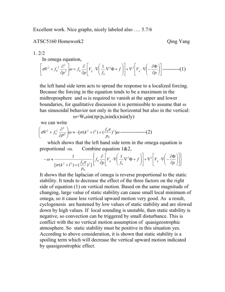
Excellent work. Nice graphs, nicely labeled also …. 5.7/6 ATSC5160 Homework2 Qing Yang 1. 2/2 In omega equation, 2 1 2 2 f f 0 Vg 2 0 2 p p f0 ----------(1) f 2 Vg p the left hand side term acts to spread the response to a localized forcing. Because the forcing in the equation tends to be a maximum in the midtroposphere and is required to vanish at the upper and lower boundaries, for qualitative discussion it is permissible to assume that has sinusoidal behavior not only in the horizontal but also in the vertical: =W0sin(p/p0)sin(kx)sin(ly) we can write 2 f 2 f 02 2 [ (k 2 l 2 ) ( 0 ) 2 ] ---------------(2) P p0 which shows that the left hand side term in the omega equation is proportional -. Combine equation 1&2, 1 f0 Vg 2 f p f0 [ (k 2 l 2 ) ( 0 ) 2 ] p0 1 f 2 Vg p It shows that the laplacian of omega is reverse proportional to the static stability. It tends to decrease the effect of the three factors on the right side of equation (1) on vertical motion. Based on the same magnitude of changing, large value of static stability can cause small local minimum of omega, so it cause less vertical upward motion very good. As a result, cyclogenesis are hastened by low values of static stability and are slowed down by high values. If local sounding is unstable, then static stability is negative, so convection can be triggered by small disturbance. This is conflict with the no vertical motion assumption of quasigeostrophic atmosphere. So static stability must be positive in this situation yes. According to above consideration, it is shown that static stability is a spoiling term which will decrease the vertical upward motion indicated by quasigeostrophic effect. 2. 2/2 b. Q3: Cold front is located at the place of strongest surface temperature gradient and apparent change of wind direction at the surface. At the region of backing region, the geostrophic wind has clockwise turning, means cold air advection. Q4: see chart. Q5:At the surface the temperature gradient is strongest at the location of cold front and the location of temperature gradient tilting to west with height, so there is moderate temperature gradient at the lower troposphere west of the cold front. The temperature gradient appears to be decrease with height, at the level of 300mb, the temperature gradient is 0, which correspond to the level of jet core. The geostrophic wind is backing in this region as shown in the region of CAA, where the thermal wind is pointed into the paper, that is almost northward. Upper level wind is the lower wind plus thermal wind, so at this region, the goestrophic wind is getting more and more southernly, and wind speed getting bigger and bigger with height till the horizontal level of 300mb, where temperature gradient is near 0, and wind speed is biggest at this level. Very good 3. 1.7/2 show location of cross section LBF-ILN b. From this chart, agostrophic wind at the entrance region of upper level jet across the isobar to the low pressure. And at the exit region, ageostrophic wind also across the isobar to the higher pressure. Analysing pressure gradient force and corriolice Coriolis force balancing, we know that the cross isobaric ageostrophic wind at the entrance and exit region allows the geostrophic wind to accelerate and decelerate respectively. At the region of the upper level trough ageostrophic wind is blowing reverse the direction of geostrophic wind, corresponding sub-geostrophic flow, and at the region of upper level ridge, ageostrophic wind is blowing along the direction of geostrophic wind, corresponding to super geostrophic flow. For corriolice force is pointing perpendicular to isobar to the high pressure, pressure gradient force has the different direction. At the ridge region, corriolice force should be bigger than pressure gradient force to generate centripetal force, that means supergeostrophic wind. At the trough region, corrioce force should be smaller than pressure gradient force to have centripetal force pointing at the same direction, so there is subgeostrophic wind. Very good c. d. The component of ageostrophic wind in this cross section shows that ahead of frontal region there is large area of rising motion, above the cold region of frontal region, there is sinking motion. It coherent with the jet stream pattern at the entrance region yes but the wave is quite short and highly curved so I think the ageostrophic upper-level divergence between the sub-geostrophic trof and supergeostrophic ridge is more important (in terms of QG thinking, PVA). For northen ageostrophic flow across the isobar, there is convergence at the upper air of LBF side and divergence at the upper air of ILN side, so corresponding the rising and sinking motion respectively. Above the cold frontal region ageotrophic wind is more eastly, and there is temperature gradient above the cold frontal region, so there is cold front aloft. By the mixing ratio line, there is dry line in the cold frontal region. It is not a dryline, it is a cold front because a dry line is characterized by ONLY moisture, no temperature gradient. At the region1 shown in the the picture, equivalent ??? potential temperature is decreasing with height, where specifically is de/dz negative (potential instability) ?? this region has CAPE and has possibility for deep convection.
