Standard-Technical-Review-Checklist-11
advertisement
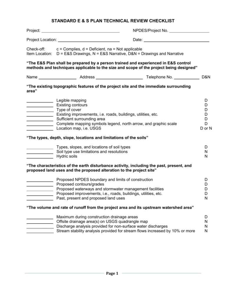
STANDARD E & S PLAN TECHNICAL REVIEW CHECKLIST Project: NPDES/Project No. Project Location: Date: Check-off: Item Location: c = Complies, d = Deficient, na = Not applicable D = E&S Drawings, N = E&S Narrative, D&N = Drawings and Narrative “The E&S Plan shall be prepared by a person trained and experienced in E&S control methods and techniques applicable to the size and scope of the project being designed” Name Address Telephone No. D&N “The existing topographic features of the project site and the immediate surrounding area” Legible mapping Existing contours ____________ Type of cover Existing improvements, i.e. roads, buildings, utilities, etc. Sufficient surrounding area Complete mapping symbols legend, north arrow, and graphic scale Location map, i.e. USGS D D D D D D D or N “The types, depth, slope, locations and limitations of the soils” Types, slopes, and locations of soil types Soil type use limitations and resolutions Hydric soils D N N “The characteristics of the earth disturbance activity, including the past, present, and proposed land uses and the proposed alteration to the project site” Proposed NPDES boundary and limits of construction Proposed contours/grades Proposed waterways and stormwater management facilities Proposed improvements, i.e., roads, buildings, utilities, etc. Past, present and proposed land uses D D D D N “The volume and rate of runoff from the project area and its upstream watershed area” Maximum during construction drainage areas Offsite drainage area(s) on USGS quadrangle map ____________ Discharge analysis provided for non-surface water discharges ____________ Stream stability analysis provided for stream flows increased by 10% or more Page 1 D N N N The location of all surface waters of this Commonwealth which may receive runoff within or from the project site and their classification under Chapter 93” Existing streams, wetlands, floodway, etc. Receiving watercourses Chapter 93 classification of streams or other waterbodies D D N “A narrative description of the location and type of perimeter and onsite BMPs used before, during and after the earth disturbance activity” Description provided in the narrative N “A sequence of BMP installation and removal in relation to the scheduling of earth disturbance activities, prior to, during and after earth disturbance activities that ensure the proper functioning of all BMPs” Complete and site specific sequence of BMP installation Activities planned to limit exposed areas Removal of temporary BMPs D D D “Supporting calculations and measurements” and “Plan Drawings” Stabilized Construction Entrance ____________ Locations ____________ Complete Details Silt Fencing Locations Slope Length ___________ Complete Details Channels ____________ Locations ____________ Drainage Areas ____________ ____________ Contours and Grades ___________ Complete details Peak flow calculations _______ _ Capacity and freeboard calculations Protective lining calculations Sediment Basins Locations Contours _________ Drainage Areas Complete berm & outlet details Cleanout information Discharge to surface waters or approved alternative Structurally sound Capacity calculations ____________ Discharge calculations Dewatering calculations Sediment Traps Locations Contours __________ Drainage Areas Complete berm & outlet details Cleanout information Discharge to surface waters or approved alternative Capacity information Discharge calculations Outlet Protection Locations Complete Details Design Calculations Inlet Protection ____________ Locations ____________ Complete Details Page 2 D D D D N N D D&N D D&N N N D D&N D N D N D Other BMPs (specify) ___________________________________________________________ __________ Locations ___________________ Complete Details __________ Design Calculations Temporary Stabilization Seed Lime Fertilizer Mulch Others Types Rates Permanent Stabilization ____________ Topsoil replacement Seed Lime Fertilizer Mulch D N D D D Others Types Rates D D “A maintenance program, which provides for the operation and maintenance of BMPs and the inspection of BMPs on a weekly basis and after each stormwater event, including the repair or replacement of BMPs to ensure effective and efficient operation. The program must provide for completion of a written report documenting each inspection and all BMP repair, or replacement and maintenance activities” _ Inspection schedule Maximum sediment storage elevation/level in BMPs Time frames for completing specific maintenance and repairs for each type of BMP proposed. Site stabilization repair parameters and directions Disposal directions for sediment removed from BMPs Note provided requiring written documentation of inspection & repair/replacement of BMPs by contractor D D D D D D “Procedures which ensure that the proper measures for the recycling or disposal of materials associated with or from the project site will be undertaken in accordance with this title” Project construction wastes are identified Directions for recycling/disposal of construction wastes Soil/rock disposal areas provided with BMPs N D D “Identification of natural occurring geologic formations or soil conditions that may have the potential to cause pollution during earth disturbance activities and include BMPs to avoid or minimize potential pollution and its impacts from the formations” Potential for geologic or soil conditions to cause pollution during construction is addressed Instructions for proper handling and/or disposal of all materials which could cause pollution are provided Typical details are provided for proper handling and/or disposal of all such materials The locations of all such materials are clearly shown on the plan maps Page 3 N D D D “Identification of the potential thermal impacts to surface waters of this Commonwealth from the earth disturbance activity including BMPs to avoid, minimize or mitigate potential pollution from thermal impacts” ____________ Analysis of how thermal impacts associated with the project will be avoided is N provided ____________ If impacts cannot be avoided, impacts are minimized and BMPs provided to D&N mitigate impacts and protect and maintain surface water quality “The E & S Plan shall be planned, designed, and implemented to be consistent with the PCSM Plan under § 102.8 (relating to PCSM requirements). Unless otherwise approved by the Department, the E&S Plan must be separate from the PCSM Plan and labeled “E&S” or “Erosion and Sediment Control Plan” and be the final plan for construction” ____________ Overall plan supports the managing of stormwater for erosion and sediment control during earth disturbance activities ____________ BMPs are compatible with and can be integrated into structural and nonstructural PCSM practices D&N D&N “Identification of existing and proposed riparian forest buffers” ____________ Existing and/or proposed buffers are shown on the plan drawings. Page 4 D
