SOUTHWEST ASIA (MIDDLE EAST)
advertisement
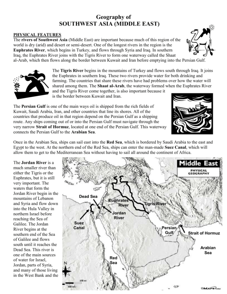
Geography of SOUTHWEST ASIA (MIDDLE EAST) PHYSICAL FEATURES The rivers of Southwest Asia (Middle East) are important because much of this region of the world is dry (arid) and desert or semi-desert. One of the longest rivers in the region is the Euphrates River, which begins in Turkey, and flows through Syria and Iraq. In southern Iraq, the Euphrates River joins with the Tigris River to form one waterway called the Shaat al-Arab, which then flows along the border between Kuwait and Iran before emptying into the Persian Gulf. The Tigris River begins in the mountains of Turkey and flows south through Iraq. It joins the Euphrates in southern Iraq. These two rivers provide water for both drinking and farming. The countries that share these rivers have had problems over how the water will shared among them. The Shaat al-Arab, the waterway formed when the Euphrates River and the Tigris River come together, is also important because it is the border between Kuwait and Iran. The Persian Gulf is one of the main ways oil is shipped from the rich fields of Kuwait, Saudi Arabia, Iran, and other countries that line its shores. All of the countries that produce oil in that region depend on the Persian Gulf as a shipping route. Any ships coming out of or into the Persian Gulf must navigate through the very narrow Strait of Hormuz, located at one end of the Persian Gulf. This waterway connects the Persian Gulf to the Arabian Sea. Once in the Arabian Sea, ships can sail east into the Red Sea, which is bordered by Saudi Arabia to the east and Egypt to the west. At the northern end of the Red Sea, ships can enter the man-made Suez Canal, which will allow them to get to the Mediterranean Sea without having to sail all around the continent of Africa. The Jordan River is a much smaller river than either the Tigris or the Euphrates, but it is still very important. The waters that form the Jordan River begin in the mountains of Lebanon and Syria and flow down into the Hula Valley in northern Israel before reaching the Sea of Galilee. The Jordan River begins at the southern end of the Sea of Galilee and flows south until it reaches the Dead Sea. This river is one of the main sources of water for Israel, Jordan, parts of Syria, and many of those living in the West Bank and the Dead Sea Euphrates River Tigris River Jordan River Suez Canal Persian Gulf Strait of Hormuz Arabian Sea Red Sea Gaza Strip. Because so much water is taken out of the Jordan River by the different groups that depend on it, less and less water reaches the Dead Sea. The Dead Sea has no outlets. Water that flows in stays there and because so much evaporates in the desert air, the water remaining is high in salts and other chemicals. There are no fish living in the Dead Sea, and that is the reason for its name. The Jordan River is also important because it is the political boundary between Israel and the West Bank, a small part of Syria, and the country of Jordan. POLITICAL FEATURES The country of Afghanistan is located at the far eastern edge of the region of Southwest Asia. The country is landlocked, which means it has no seacoast. Afghanistan is very mountainous, and the people who live there are divided into a number of different ethnic groups or tribes. Turkey Afghanistan Iran, to the west of Afghanistan, is one of the largest countries in southwest Asia. Iran is mountainous as well, but this country also has long seacoasts and is able to use both the Persian Gulf and the Arabian Sea. Iran uses the Arabian Sea and the Strait of Hormuz to transport its exports to the Arabian Sea and then on to many different world markets. Just to the west of Iran is the country of Iraq. Iraq has the added advantage of having two of the longest rivers in the region, the Tigris and the Euphrates Rivers, flowing through its territory. In southern Iraq, these two rivers join and form a waterway called the Shaat al-Arab, a river that runs for about 125 miles before it empties into the Persian Gulf. This river forms part of the international boundary between Iraq and Iran, and a number of disputes have occurred over access to the waterway. The kingdom of Saudi Arabia is the largest country of the Arabia Peninsula. The Persian Gulf lies to the northwest of the country and the Red Sea to its west. Turkey is located to the north and west of Iraq. Turkey shares a border with Iraq, Syria, and Iran. Turkey is also the country in which the Tigris and Euphrates rivers begin. Turkey has built a number of dams in recent years to try saving water from these two rivers for use by Turkish farms, villages, and towns. South of Turkey is the country of Lebanon, and south of Lebanon is Israel. Israel was created by the United Nations in 1948 as a homeland for the Jewish people of the world. The country is Israel is bound by the Gaza Strip (Gaza) along the southern coast and the West Bank to the east. The Jordan River forms the boundary between the West Bank and the country of Jordan.
