Maps
advertisement
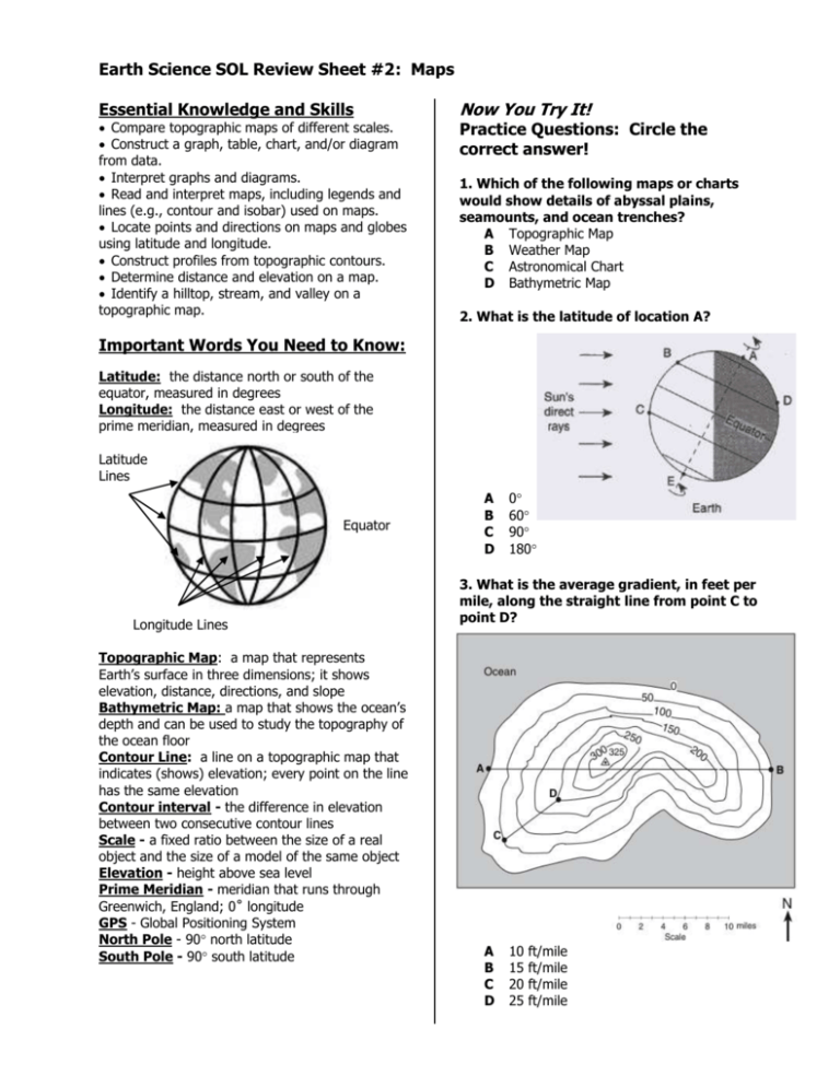
Earth Science SOL Review Sheet #2 : Maps Essential Knowledge and Skills Compare topographic maps of different scales. Construct a graph, table, chart, and/or diagram from data. Interpret graphs and diagrams. Read and interpret maps, including legends and lines (e.g., contour and isobar) used on maps. Locate points and directions on maps and globes using latitude and longitude. Construct profiles from topographic contours. Determine distance and elevation on a map. Identify a hilltop, stream, and valley on a topographic map. Now You Try It! Practice Questions: Circle the correct answer! 1. Which of the following maps or charts would show details of abyssal plains, seamounts, and ocean trenches? A Topographic Map B Weather Map C Astronomical Chart D Bathymetric Map 2. What is the latitude of location A? Important Words You Need to Know: Latitude: the distance north or south of the equator, measured in degrees Longitude: the distance east or west of the prime meridian, measured in degrees Latitude Lines Equator Longitude Lines Topographic Map: a map that represents Earth’s surface in three dimensions; it shows elevation, distance, directions, and slope Bathymetric Map: a map that shows the ocean’s depth and can be used to study the topography of the ocean floor Contour Line: a line on a topographic map that indicates (shows) elevation; every point on the line has the same elevation Contour interval - the difference in elevation between two consecutive contour lines Scale - a fixed ratio between the size of a real object and the size of a model of the same object Elevation - height above sea level Prime Meridian - meridian that runs through Greenwich, England; 0˚ longitude GPS - Global Positioning System North Pole - 90 north latitude South Pole - 90 south latitude A B C D 0 60 90 180 3. What is the average gradient, in feet per mile, along the straight line from point C to point D? A B C D 10 15 20 25 ft/mile ft/mile ft/mile ft/mile 4. Which profile BEST shows the topography between points X and Y on this map? A B 7. Your GPS unit gave your location as 14.5ºN, 49.5ºE. If you wanted to go to 10ºN, 45ºE, in which direction would you have to travel? A B C D Southwest Southeast Northeast Northwest 8. Use the map shown above. Which point is located in a valley? A Point W B Point X C Point Y D Point Z C D 9. Study the map below. Which of these could be the elevation of point X? 5. Use the map shown above. Which of these could be the elevation of the tallest hill? A 230 feet B 390 feet C 330 feet D 420 feet 6. Use the map shown above. Mill River flows northeastward to the ocean. We know that because water always flows from high elevations towards lower elevations. How else could we tell the direction of flow? A Contour lines bend uphill when they cross a river. B All rivers flow northeastward. C The river is located between to hills. D All rivers flow away from the ocean A B C D 25 30 50 55 feet feet feet feet
