Teacher notes
advertisement
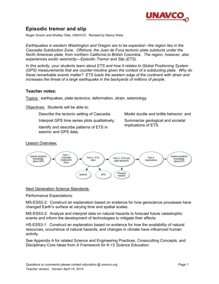
Episodic tremor and slip Roger Groom and Shelley Olds, UNAVCO. Revised by Nancy West. Earthquakes in western Washington and Oregon are to be expected—the region lies in the Cascadia Subduction Zone. Offshore, the Juan de Fuca tectonic plate subducts under the North American plate, from northern California to British Columbia. The region, however, also experiences exotic seismicity—Episodic Tremor and Slip (ETS). In this activity, your students learn about ETS and how it relates to Global Positioning System (GPS) measurements that are counter-intuitive given the context of a subducting plate. Why do these remarkable events matter? ETS loads the western edge of the continent with strain and increases the threat of a large earthquake in the backyards of millions of people. Teacher notes: Topics: earthquakes, plate tectonics, deformation, strain, seismology Objectives: Students will be able to: Describe the tectonic setting of Cascadia; Model ductile and brittle behavior; and Interpret GPS time series plots qualitatively; Summarize geological and societal implications of ETS. Identify and describe patterns of ETS in seismic and GPS data; Lesson Overview: Next Generation Science Standards: Performance Expectations: MS-ESS2-2: Construct an explanation based on evidence for how geoscience processes have changed Earth’s surface at varying time and spatial scales. MS-ESS3-2: Analyze and interpret data on natural hazards to forecast future catastrophic events and inform the development of technologies to mitigate their effects. HS-ESS3-1: Construct an explanation based on evidence for how the availability of natural resources, occurrence of natural hazards, and changes in climate have influenced human activity. See Appendix A for related Science and Engineering Practices, Crosscutting Concepts, and Disciplinary Core Ideas from A Framework for K-12 Science Education. Questions or comments please contact education @ unavco.org Teacher version. Version April 15, 2014 Page 1 Episodic tremor and slip Summary: In this activity, your students study seismic and GPS data from Cascadia to recognize a pattern in which unusual tremors--with no surface earthquakes--coincide with jumps of GPS stations. This is “Episodic Tremor and Slip.” Students model ductile and brittle behavior of the crust with lasagna noodles to understand how properties of materials depend on physical conditions. Finally, they assemble their knowledge of the data and models into an understanding of ETS in subduction zones and its relevance to residents. Grade Levels: 6 – 12 Teaching Time: Two class sessions (45 - 55 minutes). Organization: This activity consists of four principle parts: 1. Introducing or reviewing the Cascadia Subduction Zone. 2. Analyzing unusual seismic signals coincident with unexpected GPS data (after students learn to interpret GPS data). Exploration of physical models complements data analysis. 3. Making sense of the data and models in the context of a subduction zone. 4. Recognizing implications of ETS for people in Cascadia and around the Pacific Rim. General Procedure: 1. Because ETS is unusual, you’ll want to stage this lesson after students have learned about typical earthquakes and have a background in plate tectonics. 2. You’ll also benefit from assessing how much your students know about GPS. Ask them, for example, how do they use GPS? How do they think geologists use GPS? The PowerPoint presentation “Episodic Tremor and Slip: The Case of the Mystery Earthquakes” explains briefly how to interpret GPS data. However, if you have the time and inclination, the activity “Measuring plate motion with GPS” teaches in greater depth how a GPS works and how to interpret GPS data. 3. Begin the lesson with the PowerPoint presentation “Episodic Tremor and Slip: The Case of the Mystery Earthquakes.” The lesson goes hand-in-hand with a student worksheet. 4. Work through the presentation with your students. Notes below the slides both provide background geology and teaching tips. 5. Assess what your students have learned by doing this activity. You could ask them to draw a concept map for ETS that brings in seismicity, GPS, and plate tectonics. Or, they could write a few paragraphs about ETS. They could draw a cartoon cross-section that compares and contrasts coastal Cascadia with the inland urban corridor and continental interior in terms of seismicity and GPS data. You could, of course, simply grade their worksheets. Materials list: Student worksheets, computer and projector, quick-cook lasagna noodles, a source of warm water, and large beakers for each group. Questions or comments please contact education @ unavco.org Teacher version. Version April 15, 2014 Page 2 Episodic tremor and slip The Basics: Review of the Cascadia Region Lead into this lesson with the PowerPoint presentation. Here is a Google Earth© image of the Cascadia region: British Columbia Let’s review a few things: 1. What type of boundary exists between the Juan de Fuca plate and the North American plate? [converging] Washington Pacific plate 2. What types of tectonic plates are they? Juan de Fuca: [oceanic] North American: [continental] 3. Because the Juan de Fuca Plate is denser than the North American plate, it is slipping underneath the North American Plate. What do we call this process? [subduction] Juan de Fuca plate A North American Oregon plate 4. Apply the general animation to the Cascadia region. California What overall direction would you expect point A (on the map) to be moving due to the deformation? How do you know that? [Point A would move to the northeast because the Juan de Fuca plate subducts and pushes against the continental margin.] Hmmmm . . . What’s happening here? Strange seismic signals that lasted a really long time – weeks – as opposed to seconds or minutes. They released the same amount of energy as a sudden earthquake – it was just spread out over a longer time GPS monuments in certain areas were showing reversals of their long-term northeast movement. Every so often they would move southwest. A pattern emerges . . . 5. From looking at the data, describe the direction of movement of the western edge of the North American Plate between 1996 and 1999. Remember this is a time series plot – look carefully at what is being measured on the Y-axis! [Overall the GPS station moves to the east. However, there are periodic small jumps back to the west.] 6. About how often does the reverse motion happen? [about every 14 to 15 months] Questions or comments please contact education @ unavco.org Teacher version. Version April 15, 2014 Page 3 Episodic tremor and slip 7. Approximately how many millimeters of reverse motion occurs during each slip event? [Reverse motion is about 6 mm west each time, when looking only at this east-west data. (Overall, the motion is to the southwest.)] Putting the pieces together 8. Now, what do you notice about the seismograms? [All the seismograms show similar tremor patterns across a wide area.] Now what? Implications of what we’ve learned 9. What does the data show? Did PABH experience a reverse motion or slow slip event? [No, there was no southwest motion.] 10. Explain how the data from PABH differs from observations at ALBH. [While there are slip events at ALBH, PABH didn’t seem to be affected by ETS.] Let’s try to model what’s happening with the Juan de Fuca Plate as it moves under the North American Plate. 11. Take the noodle out of the water. Gently bend the lasagna on the part that was in the warm water. Describe what happens. [The part of the noodle soaking in water is limp and bendable.] 12. Now, using the same amount of pressure as you did in question 11, try to bend the part that was not in the water. What happens? [The part of the noodle that stays out of the water bows into a taut shallow curve.] 13. Keep applying pressure to the cool, dry lasagna. What eventually happens? [The noodle snaps into pieces.] 14. How do you think this models what’s happening with the subducting Juan de Fuca plate? Tie in the idea of the “locked” zone and the “slip” zone. [The cold lasagna is analogous to the locked zone: it flexes until the strain exceeds the strength of the material, when it breaks and releases energy. The warmed lasagna noodle is analogous to the zone in the crust that slips without an abrupt release of energy.] Questions or comments please contact education @ unavco.org Teacher version. Version April 15, 2014 Page 4 Episodic tremor and slip 15. After watching the animation, draw in what the time series plots look like for the three zones: Locked Slow slip No slip Why Episodic Tremor and Slip matters Station C 0 Time East Displacement (mm) East Displacement (mm) 16. Draw a sketch of what the time series plots looked like for stations located at C and D on the map. This is just one instance of a slow slip event. Don’t worry about where to start the line – you can start it either below the 0 line or right on it. Station D 0 Time The BIG picture: 17. Given a “slip-deficit” of 3 centimeters per year, how much would accumulate in 500 years? About how many feet is that? [1500 centimeters, or 15 meters.] 18. Why would predicting when a great earthquake and tsunami would happen be so important? [Being able to predict an earthquake and ensuing tsunami could prevent injury and death of many people. With enough warning, people could also move their belongings to higher or more stable ground.] Questions or comments please contact education @ unavco.org Teacher version. Version April 15, 2014 Page 5 Episodic tremor and slip Appendix A: Relevant excerpts from A Framework for K-12 Science Education as cited in the Next Generation Science Standards Science & Engineering Practices in the NGSS: Developing and using models; Analyzing and interpreting data; Using mathematics and computational thinking; and Constructing explanations (for science) and designing solutions (for engineering). Crosscutting Concepts: Patterns; scale, proportion, and quantity; and cause and effect. Disciplinary Core Ideas: PS2.A: Forces and Motions: All positions of objects and the directions of forces and motions must be described in an arbitrarily chosen reference frame and arbitrarily chosen units of size. In order to share information with other people, these choices must also be shared. [Grade 8] ESS1.C: The History of Planet Earth: Tectonic processes continually generate new ocean floor at ridges and destroy old floor at trenches. [Grade 12] ESS2.A: Earth’s Materials and Systems: All Earth processes are the result of energy flowing and matter cycling within and among the planet’s systems. This energy is derived from the sun and Earth’s hot interior. The energy that flows and matter that cycles produce chemical and physical changes in Earth’s materials and living organisms. [Grade 8] ESS2.A: Earth Materials and Systems: Evidence from deep probes and seismic waves, reconstruction of historical changes in Earth’s surface and its magnetic field, and an understanding of physical and chemical processes lead to a model of Earth with a hot but solid inner core, a liquid outer core, a solid mantle and crust. Motions of the mantle and its plates occur primarily through thermal convection, which involves the cycling of matter due to the outward flow of energy from Earth’s interior and gravitational movement of denser materials toward the interior. [Grade 12] ESS2.B: Plate Tectonics and Large-Scale System Interactions: Plate tectonics is the unifying theory that explains the past and current movements of the rocks at Earth’s surface and provides a framework for understanding its geologic history. Plate movements are responsible for most continental and ocean-floor features and for the distribution of most rocks and minerals within Earth’s crust. Maps of ancient land and water patterns, based on investigations of rocks and fossils, make clear how Earth’s plates have moved great distances, collided, and spread apart. [Grade 8] ESS3.B: Natural Hazards: Mapping the history of natural hazards in a region, combined with an understanding of related geologic forces can help forecast the locations and likelihoods of future events. [Grade 8] ESS3.B: Natural Hazards: Natural hazards and other geologic events have shaped the course of human history; [they] have significantly altered the sizes of human populations and have driven human migrations. Grade 12] Questions or comments please contact education @ unavco.org Teacher version. Version April 15, 2014 Page 6
