Yale 1981 Study
advertisement
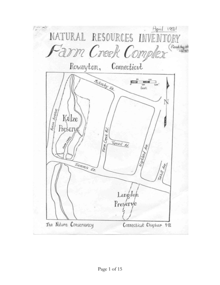
Page 1 of 15 INTRODUCTION The William J. Kulze and Langdon Preserves, comprising 4.5 acres (1.8 nectares) owned by The Nature Conservancy, are located on Farm Creek, a tidal extension of Wilson Cove, which is part of the Sheffield Island Harbor in Rowayton, Connecticut. It is located 41004'30" north latitude, 73027'31" west longitude (USGS topographic map, Norwalk South Quadrangle, 7.5 minute series). Elevation ranges from 0 to 10 feet (0- 3 m) above sea level. The Kulze Preserve, a salt marsh of 4 acres, is situated at the head of the Farm Creek estuary. It is bounded to the north, south, and west by streets, McKinley, Sammis, and Roton, respectively, and to the north and east by residences. Saltwater cord grass dominates the creek banks at the mean high water mark. Salt-meadow cord grass, spike grass, and black grass are found growing on relatively higher parts of the marsh, while reed grass and other weedy species thrive in areas disturbed by previous filling. Underlying the marsh deposits and fill is glacial till. The soil is West-brook Peat. The tidal marsh preserve was donated "to The Nature Conservancy in 1973-74 by Mr. William J. Kulze. The Langdon Preserve exists as a 55 foot wide strip extending southwesterly from the intersection of Highland Avenue and Sammis Street to Farm Creek. It was the bed of an old trolley line. It occupies approximately three-eighthsacre of upland and one-eighth acre of salt marsh on Farm Creek and thus provides an interesting break from salt marsh to upland vegetation. Its soil is characterized as the Charlton very stony, fine sandy loam. This important addition in the preservation of the Farm Creek tidal marshes came to The Nature Conservancy in 1974-1976 as a gift from Philip and Carolyn Langdon. A desciption of the vegetation will be found later in this document. The two preserves have been and shall be used extensively for educational purposes; their promixity to two public schools and a public natural area with a freshwater pond helps to insure the preserves' continuing use as a teaching tool. The two preserves are located in the Western Coastal Ecoregion of Page 2 of 15 Connecticut (DoWhan and Craig, 1976). The mean annual temperature is about 50.50F (310C). The average winter temperature is 310F (-.50C). The frost free season averages about 180 days. Annual precipitation is around 43" (109.2 cm). Parts of the natural resouces inventory - the vegetation map, animal and plant species lists and history - were done by M. Yvonne Gonzalez and Phillip Dibner, students from the Yale School of Forestry & Environmental Studies, and later compiled in greater detail by the Farm Creek Committee; the inventory itself was written by Loretta Johnson, a graduate of Connecticut College. It was made possible through a grant from the Charles Steward Mott Foundation which came to The Nature Conservancy was made available to the Connecticut Chapter. HISTORY The most recent geologic force to greatly affect the topography of Connecticut occurred some 12,000 years ago with the retreat of the final, Wisconsin glacier. Ice scoured rock and soil from the land. A terminal moraine (the piling up of eroded materials called drift) formed Long Island, marking the southern border of the glacier. As the ice melted, glacial outwash in the "form of sand and gravel was deposited in Long Island Sound, then a fresh water lake. The rise in sea level allowed ocean waters into the basin making the Sound an extension of the sea. The shoreline of Connecticut is relatively young, having been formed during the postglacial rise in sea level. Its irregular, indented nature has produced many sheltered harbors which have attracted man for thousands of years. The first people in New England were small groups of Indians who hunted, fished, and gathered nuts, seeds, roots, and shellfish. The bands were seminomadic, with some permanent settlements near localities with an abundance of shellfish. During 900-1300 A.D., agriculture, art, and religion expanded and developed to varying degrees in eastern North America. From 1300 to 1700, most native people of New England were primarily dependent upon agriculture (mostly corn), secondarily upon hunting, fishing, and gathering, and lived a basically sedentary village life in designated tribal lands. Very little precise information is available about Connecticut Indians. They had no writing, and their quick demise at European contact Page 3 of 15 precluded much investigation. This contact was an almost immediate disaster to the native Connecticut peoples. A plague in 1616-17 killed thousands of Indians in New England. During early colonial times in Rowayton, the salt hay, Spartina alterniflora, was probably harvested from the Farm Creek marsh for roof thatching and as livestock feed. The preserve committee has collected old black and white photographs of the area. As far back as is recorded on film and as anyone can remember, the area has been salt marsh; no buildings were ever built there. Neighbors once constructed a stone dam near the Sammis Street bridge in an effort to create a pond. This project resulted in several flooded basements so the dam was then partially dismantled to allow tidal flushing. Today the ruins of this dam still have an adverse effect on the volume of tidal flow. HYDROLOGY The Farm Creek tidal marsh system has suffered a number of man-made hydrologic disturbances. Maps dating back to 1886 show that land to the east of the Kulze Preserve was once marsh. However, even at that time, man had already started to fill in the marsh in order to build homes and continued to fill thereafter. About 13 years ago, the preserve was used as a dumping ground for the dredge spoil from the Five Mile River, while filling with construction waste material along Roton Avenue continued until the marsh was donated to The Nature Conservancy in 1973-74. A tributary stream, which originally flowed into the northern section of Farm Creek, was dammed to make a freshwater pond. The reduced flow of freshwater now enters Farm Creek through a culvert under McKinley Street. Furthermore, a channel from Five Mile River which flowed into the mouth of Farm CFeek was completely £illed. In the early 1960's, a dam was built beneath the Sammis Street bridge which spans the southern end of the Kulze Preserve. As a result, the tidal marsh became a freshwater pond. The dam has since washed away, but enough rubble remains to impede the flow of the tide. Today, the Farm Creek tidal marsh system receives freshwater runoff from bordering roads and residences, and saltwater from the incoming tides. Page 4 of 15 BEDROCK GEOLOGY The Farm Creek Complex is underlain by massive felsic gneiss of intrusive origin. The gneiss consists of feldspar-rich minerals, such as plagioclase, quartz, microcline, muscovite, and biotite, in order of decreasing abundance. The rock is medium grained to pegmatitic, poorly foliated gneiss. Outcrops fracture to produce blocks often 1- 4 m on a side. There are no outcrops on the preserve. Weathered rock appears gray, buff, or orange with rust surfaces uncommon. SURFICIAL GEOLOGY Surficial deposits in the vicinity of Farm Creek are products of the wisconsin glaciation. Twenty-thousand years ago, the Wisconsin glacier covered New England, scouring the land's surface. The ice deposited a carpet of till, an unsorted mixture of boulders, gravel, sand and clay which underlies the more recent tidal marsh and whose surface occurs on the upland portion of the Langdon Preserve. Melt water streams, with Five-Mile River and Norwalk River as remnants, drained the melting ice mass forming terraces of 0stratified sand and gravel about 30 feet (9 m) deep (Malde, 1968). About 18,000 years ago the glacier reached its southern limit, extending Across the present Long Island basin to sout4ern Long Island. The southern margin of the glacier remained there for A time in an "equilibrium" position dumping its load of till as the movement of ice southward was offset by the melting of the ice front due to a regional warming trend. The ice mass began its retreat when the balance was upset; southerly ice flow decreased and melting increased. About one and a half miles due southeast, the Norwalk Islands represent remnants of the end moraine. The basin of Long Island Sound predates glaciation and is probably a stream-carved feature. The sound remained a freshwater lake until approximately 8,000 years ago by which time the sea level had risen to 25 m below the present level. At this point, seawater entered the central basin of Long Island Sound, changing it from a freshwater lake to an arm of the sea. The climate continued to warm and the melting of the glacier led to further rises in sea level and to the drowning of the coastline. Eventually the sea drowned the Norwalk and Five Mile Rivers. Tidal action reworked the till and deposited fine-grained material in sheltered areas like Farm Creek. About 3,000 Page 5 of 15 years ago the rate at which the sea level rose slowed enough that salt marshes could become established. *From Krol1, R.L. 1977. The Bedrock Geology of the Norwalk North and Norwalk South Quadrangles. State Geol. and Natural Hist. Survey of Conn. Quad. Rept. #34. SOILS Marsh deposit is present over most of the Kulze parcel and the seaward part of the Langdon tract. It is part of the Westbrook Peat Series, composed of sand, silt, and clay mixed with partially decomposed plant remains, having developed on the coastline where flooding occurs at high tide. The salt content of the peat is usually in excess of ten parts per thousand. Commonly this soil is underlain by up to 20 feet (6 m) of glacial till, a non-sorted mixture of boulders, gravel, sand, and clay deposited directly by the glacier. Fill, ranging from dredge spoils from the dredging of the Five Mile River to construction waste material, was dumped on the western side of Farm Creek along Roton Avenue. This disturbed area is now marked by an extensive stand of reed grass, Phragmites communis. Since the Farm Creek marsh's protection as a nature preserve, much of the fill has been removed by the local Preserve Stewardship Committee. Charlton very stony fine sandy loam occupies the upland portion of the Langdon parcel. It is a sloping well-drained upland soil, developed in very friable to firm glacial till. Surface soil and subsoil texture to a depth of 20 to 30 inches (50-75 cm) is fine sandy loam with some small, angular rock fragments. The underlying material is sandy loam or fine sandy loam with many gravel size rock fragments in places. These soils are moderately permeable. Some of the rocks forming the base for the trolley line are still visible. *From Fairfield County Soil Conservation District, 1977 Special Report Soil Survey and Soil Interpretation for Fairfield County, Connecticut. VEGETATION Methodology Page 6 of 15 A permanent grid system, dividing the Kulze Preserve into Sm x 3m plots and oriented perpendicular to Sammis Street, was established in June 1979 to delineate plant communities and to document vegetation changes. A grid system was not established for the Langdon Preserve. However, this parcel was briefly inventoried by a field reconnaisance on March 10, 1981 and a description of its vegetation follows. Description of Plant Communities The Kulze Preserve supports three plant co~unities: a saltwater cord grass community along the tidal banks of Fa~ Creek, a salt-meadow community on the higher and drier parts of the salt Darsh, and a community comprised of weedy species found growing on disturbed areas. The Langdon Preserve also supports three plant communities: a saltwater cord grass co~unity at the southernmost end, a salt-meadow comnunity on the higher part of the salt marsh, and a woody upland. The upland comprises 3/4 of the preserve. Factors which control species composition and distribution include elevation and tidal regiDe, salinity, drainage, and land use history. Saltwater Cord Grass Community The sloping banks of Farm Creek support a distinct community of saltwater cord grass, (Spartina alterniflora). This grass generally grows where flooded twice daily by the tide. The height of saltwater cord grass is correlated with tidal range, growing to a height which approximately equals the tide range -- about 5-6 feet in Rowayton. This grass facilitates an increase in marsh elevation by stabilizing the mud and trapping more sediment as the tide floods the marsh surface. Gradually, the marsh surface becomes elevated with peat, the partially decomposed plant remains mixed with ~ud, and becomes a good environment for less salt-tolerant grasses such as are found in the salt-meadow community. Salt-Meadow Community. The salt-Deadow community exists in several large patches landward and slightly higher than the saltwater cord grass co~unity and tidal mudflats. The salt-meado", is rarely completely flooded. Consequently, this part of the tidal marsh is drier, exhibiting a species composition different from that on the tidal banks. The most common species are salt-meadow cord grass (Spartina patens), and spike grass (Distichlis spicata). These two species grow in several pure Page 7 of 15 stands, as well as codominating. Orach (Atriplex sp.) and sea lavender (Limoniun carolinianum) are interspersed. On the upper border of the salt marsh, which seldom gets flooded except during extreDely high tide, Darsh elder (Iva frutescens), commonly called "high tide bush", and seaside goldenrod (Solidago sempervirens) can be found . Black grass (Juncus gerardi) occupies areas on the upper border where it presumably receives the influence of freshwater seepage from road runoff. Disturbed Area: Weedy Species Weedy species, the most conspicuous being the tall reed grass (Phraqmites communis), occupy an extensive band along Roton Avenue, and two narrow strips borde; the backyards of Farm Creek Road residences. The growth of weedy species can be attributed to past Darsh disturbance, namely the dumping of waste fill along Roton Avenue and Farm Creek Road to extend house lots. The part of the Kulze Preserve along Roton Avenue is especially removed from tidal influences and consequently can support upland trees such as red mulberry (Morus rubra) , and smooth sumac (Rhus glabra) .Upland herbs such as sweet clover-(Melitotus alba), red clover (Trifolium pratense) and the woody vine, virginia creeper (Parthenocissus quinquefolia)also occupy this site. Partial Plant Species List Scientific Name/Common Name Acer negundo - box elder AeSCulus hippocastanum - horse chestnut Arctium minus - burdock Aster divaricatus - white wood aster Aster subulatus - annual salt marsh aster Atriplex sp. - orach Betula populifolia - gray birch Carya cordiformis - bitternut hickory Carya tomentosa - mockernut hickory Celastrus scandens - bittersweet Page 8 of 15 Chenopodium album - pigweed Clematis sp. Daucus carota - Queen Anne's lace Distichlis spicata - spike grass Iva frutescens - marsh elder Juncus Qerardi - black grass Juncus roemerianus Lepidium virqinicum - poorman' s pepper Limonium carolinianum - sea lavender Lonicera japonica - Japanese honeysuckle Melilotus alba - white sweet clover Morus rubra - red mulberry Panicum sp. - panic grass Parthenocissus quinquefolia - virginia creeper Phragamites communis - reed grass Phytolacca americana - pokeweed Plantago sp. - plantain Prunus serotina - black cherry Quercus rubra - red oak Rhus glabra - smooth sumac Rosa multiflora - multiflora rose Rubus sp. - blackberry Rumex crispus .- dock Salicornia spp. - glasswort . Salix discolor. - pussy willow. , Salix nigra. - black willow Sassafras albidum - sassafras Scirpus sp. - bulrush Setaria sp. - fox tail grass Solanum dulcamara - deadly nightshade Solidago sempervirens .- seaside goldenrod Spartina alterniflora - saltwater cord grass Spartina patens - salt-meadow cord grass Taraxacum officinale - dandelion Thuja occidentalis - arbor-vitae Tilia sp. Trifolium pratense - red clover Compiled in part by M. Yvonne Gonzalez, as part of a cooperative project between The Nature Conservancy and the Yale School of Forestry and Environmental Studies, by Loretta Johnson, an intern with The Nature Page 9 of 15 Conservancy, and by the Farm Creek Stewardship Committee. It is by no means a complete list. LANGDON PRESERVE VEGETATION The half-acre Lang~n preserve was once an old trolley right-of-way. It is comprised of four main plant communities: a saltwater cord grass, saltmeadow cord grass, phragmites, and oak-hickory upland. The saltwater cord grass community of spartina alterniflora is located at the southernmost portion of the preserve, and occupies a small fraction of the total parcel. It is partially submerged at high tide. The salt-meadow cord grass cornmunity is mostly an even mixture of saltmeadow cord grass (spartina patens) and spike grass (Distichlis spicata). Sea lavender (Limonium carolinianum) and glasswort (salicornia sp.) are codominant in this small salt-meadow as well as marsh elder (Iva frutescens). Panic grass (Panicum spp.) is found at the upper border of the salt-meadow and delineates the upper border of the salt-meadow cord grass community. The land slopes slightly upward to the north, and the soil has been disturbed by the addition of rocky fill. Reed grass (Phragmites) grows well here and is interspersed with several small trees and shrubs, the largest of which measures six feet. White oak (Quercus alba), and gray birch (Betula populifolia), are quite common as well as smooth sumac (Rhus glabra). The oak-hickory upland community is comprised of small shrubs and trees with a thick undergrowth of multiflora rose (Rosa multiflora), Japanese honey suckle (Lonicera japonica) and catbrier (Smilax rotundifolia). This undergrowth almost completely blocks passage through this parcel of land. The small trees and shrubs are evenly distributed as to species and many seem stunted by the thick entanglement of undergrowth. Common species occuring are: white oak (Quercus alba), scrub oak (Quercus ilicifolia), gray birch (Betula populifolia), smooth sumac (Rhus glabra), and winged euonymous, (Euonymous alatus). The hickories: bitternut (Carya cordiformis), and mockernut (C. tomentosa) are also evenly distributed. They are stunted except close to Sammis Street Page 10 of 15 where a few larger specimens (to about 25 feet) occur. A few large black willows (Salix nigra) can be found on the east side of the preserve shortly after one enters. A few escaped ornamentals also occur on the parcel of land. There is a stand of three large fifty-foot Douglas firs (Pseudotsuga sp.) as well as arbor-vitae (Thuja occidentalis) in the area. In conclusion, the Langdon Preserve has a small salt-marsh but is mainly a shrubby upland with a dense undergrowth and a population of escaped ornamentals. Large trees are few in number and most occur within the northern quarter of the preserve. SPECIES COMMON TO LANGDON PRESERVE Betula populifolia - grey birch Carya cordiformis - bitternut hickory C. tomentosa - mockernut hickory Daucus carota - Queen Anne's lace Distichlis spicata - spike grass Euonymous alatus - winged euonymous Iva frutescens - marsh elder / Limonium carolinianum - sea lavender Lonicera japonica - Japanese honey suckle Panicum spp. - panic grass Phragrnites - reed grass Pseudotsuga - Douglas fir Quercus alba - white oak Q. ilicifolia - scrub oak Rhus glabra - smooth sumac Rosa multiflora - multiflora rose Salicornia spp. - glass wort Salix nigra - black willow Spartina alterniflora - saltwater cord grass Smilax patens salt-- meadow cordgrass Smilax rotundifolia - catbrier Thuja occidentalis - arbor-vitae. FAUNA . Page 11 of 15 The following birds have been seen visiting Farm Creek Complex: Mute Swan, Black-capped Chickadee, Canada Goose, Tufted Titmouse, Mallard Duck, Mockingbird, Marsh Hawk, Robin, American Egret, Starling, Snowy Egret, Myrtle Warbler, Great Blue Heron, Yellow Throat, Louisiana Heron, Red-winged Blackbird, Green Heron, Common Grackle, Blackcrowned Night Heron, Brown-headed Cowbird, Yellow-crowned Night Heron, Northern Oriole, Glossy Ibis, Cardinal, Clapper Rail, House Finch, Blackbellied Plover, Goldfinch, Killdeer, Junco, Semipalmated Plover, Whitethroated Sparrow, Greater Yellowlegs, Song Sparrow, Dunlin, Tree Sparrow, Sanderling, House (English) Sparrow, Herring Gull, Lapland Longspur, Ring-billed Gull, Laughing Gull, Bonaparte's Gull, Common Tern, Mourning Dove, Belted Kingfisher, Yellow-shafted Flicker, Eastern Kingbird, Eastern Phoebe, Barn Swallow, Tree Swallow, Rough-winged Swallow, Blue Jay, Common Crow. BIBLIOGRAPHY Adams, Alex and Lucy. Personal communication about history, fauna list. Bloom, A.L. and M. Stuiver, 1963. Submergence of the Connecticut eoast. Sci. 139:332-334. Bloom, A.L. and C.W. Ellis, 1965. Postglacial Stratigraphy and Morphology of Coastal Connecticut. Conn. State Geol. and Nat. Hist. Survey, Guidebook #1. 10 pp. Dowhan, J.J., and R.J. Craig, 1976. Rare and Endangered Species of Connecticut and Their Habitats. Conn. State Geol. and Nat. Hist. Survey, Report of Investigations #6. 137 pp. Ellis, C.W., 1962. Marine Sedimentary Environments in the Vicinity of the Norwalk Island, Connecticut. Conn. State Geol. and Nat. Hist. Survey, Bull. #93. 89 pp. Fairfield County Soil Conservation District, 1977. Special Report: Soil Survey and Soil Interpretations for Fairfield County, Connecticut. 64 pp. & maps. Farm Creek Committee, 1973- 80. Unpublished inventory data. Page 12 of 15 Goodwin, R.H. (ed), 1961. Cpnnecticut's Coastal Marshes --A Vanishing Resource. Conn. Arboretum Bull. #12. 36 pp. Hill D.E. and A.E. Shearin, 1970. Tidal Marshes of Connecticut and Rhode Island. Conn. Ag. Expt. Station, Bull #709. 34 pp. Kroll, R.L., 1977. The Bedrock Geology of the Norwalk North and Norwalk South Quadrangles. Conn. State Geol. and Nat. Hist. Survey, Quadrangle Report #34. 55 pp. Malde, H.E., 1968. Surficial Geologic Map of the Norwalk South Quadrangle. United States Geologic Survey and Conn: State Geol. and Nat. Hist. Survey, Map GQ-718. Miller, W.R., and F.E. Egler, 1950. Vegetation of the WequetequockPawcatuck Tidal Marshes, Conn~cticut. Ecol. Monogr. 20:143-172. Niering, W.A., and R.S. Warren (eds), 1974. Tidal Wetlands of Connecticut. Vegetation and Associated Animal Populations, Vol. 1. Conn. State Dept. of Environmental Protection. 45 pp. Niering, W.A., R.S. Warren, and C.G. Weymouth, 1977. Our Dynamic Tidal Marshes: Vegetation Changes As Revealed by Peat Analysis. Conn. -Arboretum Bull. #22. 12 pp. Redfield, A.C., 1972. Development of a New England Salt Marsh. Ecol. Monogr. 43:201-237. Steever, E.Z., 1972. Productivity and Vegetation Studies of a Tidal Salt Marsh in Stonington, Conn.: Cottrell Marsh. Master's Thesis, Conn. College, New London. 74 pp. Teal, J., and M. Teal, 1969. Life and Death of the Salt Marsh, New York. Intext Publishing. 274 pp. Page 13 of 15 Page 14 of 15 Page 15 of 15
