Case Example - Cloudfront.net
advertisement
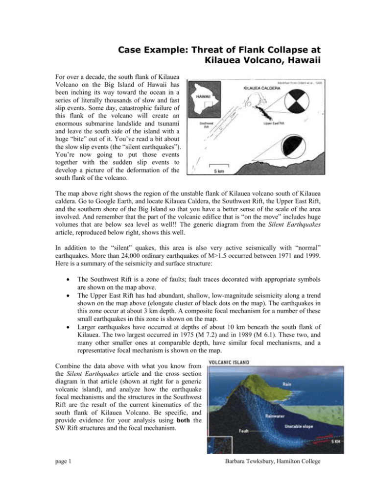
Case Example: Threat of Flank Collapse at Kilauea Volcano, Hawaii For over a decade, the south flank of Kilauea Volcano on the Big Island of Hawaii has been inching its way toward the ocean in a series of literally thousands of slow and fast slip events. Some day, catastrophic failure of this flank of the volcano will create an enormous submarine landslide and tsunami and leave the south side of the island with a huge “bite” out of it. You’ve read a bit about the slow slip events (the “silent earthquakes”). You’re now going to put those events together with the sudden slip events to develop a picture of the deformation of the south flank of the volcano. The map above right shows the region of the unstable flank of Kilauea volcano south of Kilauea caldera. Go to Google Earth, and locate Kilauea Caldera, the Southwest Rift, the Upper East Rift, and the southern shore of the Big Island so that you have a better sense of the scale of the area involved. And remember that the part of the volcanic edifice that is “on the move” includes huge volumes that are below sea level as well!! The generic diagram from the Silent Earthquakes article, reproduced below right, shows this well. In addition to the “silent” quakes, this area is also very active seismically with “normal” earthquakes. More than 24,000 ordinary earthquakes of M>1.5 occurred between 1971 and 1999. Here is a summary of the seismicity and surface structure: The Southwest Rift is a zone of faults; fault traces decorated with appropriate symbols are shown on the map above. The Upper East Rift has had abundant, shallow, low-magnitude seismicity along a trend shown on the map above (elongate cluster of black dots on the map). The earthquakes in this zone occur at about 3 km depth. A composite focal mechanism for a number of these small earthquakes in this zone is shown on the map. Larger earthquakes have occurred at depths of about 10 km beneath the south flank of Kilauea. The two largest occurred in 1975 (M 7.2) and in 1989 (M 6.1). These two, and many other smaller ones at comparable depth, have similar focal mechanisms, and a representative focal mechanism is shown on the map. Combine the data above with what you know from the Silent Earthquakes article and the cross section diagram in that article (shown at right for a generic volcanic island), and analyze how the earthquake focal mechanisms and the structures in the Southwest Rift are the result of the current kinematics of the south flank of Kilauea Volcano. Be specific, and provide evidence for your analysis using both the SW Rift structures and the focal mechanism. page 1 Barbara Tewksbury, Hamilton College
