Geology of Washington Mini-Textbook
advertisement
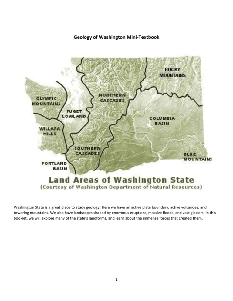
Geology of Washington Mini-Textbook Washington State is a great place to study geology! Here we have an active plate boundary, active volcanoes, and towering mountains. We also have landscapes shaped by enormous eruptions, massive floods, and vast glaciers. In this booklet, we will explore many of the state’s landforms, and learn about the immense forces that created them. 1 Setting the Stage: The Convergent Plate Boundary About 200 million years ago, the supercontinent Pangaea began to break up. A divergent plate boundary formed between what is now North America, Africa, and Europe causing the continents to rift apart. As the continents drifted away from each other, the Atlantic Ocean grew wider. Control click to see an animation of the breakup of Pangaea: http://www.divediscover.whoi.edu/tectonics/pangea-animation.html As the continents moved, a convergent plate boundary formed along the northwest edge of what is now the United States. Today, we call this plate boundary the Cascadia Subduction Zone. The oceanic Juan de Fuca plate is diving down under the North American continental plate. As the oceanic plate sinks into the mantle, it melts and is destroyed. Image: http://geology.com/nsta/convergent-plate-boundaries.shtml The Cascadia Subduction Zone directly causes many of the landforms you see around us today. 2 Formation of Washington State When Pangaea broke up, most of Washington didn’t exist yet. As the oceanic plate dove under North America, it carried small continents, island arcs, and ocean sediments with it. Over millions of years, these rocks and sediments piled up against the west coast, building more and more land. As the land built up, the subduction zone moved westward and stayed right along the coast. Everything on the map below that is not purple was added on to the state by the subduction zone. Image: http://www.burkemuseum.org/static/geo_history_wa/New%20Lands%20Along%20an%20Old%20Coast%20v.2.7.htm 3 Earthquakes & Faults Earthquakes occur along all plate boundaries. As the oceanic plate sinks below the continent, it sometimes gets stuck. Stress builds up and is eventually released by a sudden motion of the plates. This is a subduction zone earthquake. The longer the oceanic plate gets stuck, the more stress builds up, and the larger the earthquake will be when it releases. Our area experiences major subduction earthquakes every 300 to 500 years. The last large earthquake is believed to have occurred about 300 years ago. Image: http://www.capemeares.org/news/315th-anniversary-of-the-great-1700-cascadia-subduction-zone-cszearthquake-and-tsunami/ A subduction earthquake can cause major damage to buildings. It can also cause landslides, and generate massive ocean waves called tsunamis. This is why having earthquake drills is so important here! The link for the image above gives a detailed description of the last subduction earthquake to occur here. The pressure on the continental plate from the subduction zone also causes the continental crust to crack in places. These cracks are called faults. Sometimes there is motion along these faults, and that causes smaller earthquakes. There are earthquakes along small faults in the Pacific Northwest every single day. The map to the left shows faults in the Puget Sound region. Image: https://en.wikipedia.org/wiki/Puget_Sound_faults Check out this interactive map, which lists and shows locations of all recent earthquakes in our region. http://pnsn.org/earthquakes/recent For more details about earthquakes and how we study them: http://earthquake.usgs.gov/learn/kids/eqscience.php 4 Columbia Plateau The Columbia Plateau covers much of Eastern Washington, as well as parts of Oregon and Idaho. A plateau is a broad, flat area of land. About 17 million years ago, lava spilling over the land from a series of at least 300 massive eruptions (called flood basalt eruptions) formed the Columbia Plateau. The eruptions probably came out of cracks or fissures that opened in the crust of the Earth. The fissures are now buried beneath the hardened lava. The eruptions lasted for millions of years. The lava piled up in layers, eventually reaching a thickness of almost 6000 feet (1.8 km). That’s as tall as 10 Space Needles stacked on top of each other! The lava covers an area of 63,200 square miles (163,700 km). Image: http://geology.isu.edu/Digital_Geology_Idaho/Module10/mod10.htm Where the Columbia River has cut into the plateau, you can see some of the layers of lava stacked one on top of another. Geologists aren’t sure what caused the flood basalt eruptions. One of the most popular ideas is that there is a hot spot in the mantle under the crust of North America. This hot spot would periodically trigger volcanic activity in the crust above it as the North American plate slowly moves over it. This same hot spot may have also caused the volcanic activity at Craters of the Moon in Idaho and the current geothermal activity in Yellowstone National Park. Hawaii is also an example of volcanic activity that we think is caused by a different hot spot in the mantle. Image: http://columbiariverimages.com/Regions/Places/wallula_gap.html Another possible cause of the Columbia flood basalt eruptions is the subduction plate boundary off the Washington coast. It may be that oceanic plate temporarily changed direction or stopped moving. This would have released the stress on the North American plate. As the North American plate “relaxed,” fissures could have opened up in what is now Eastern Washington, leading to the eruptions. 5 During the most recent ice age, glaciers crept down from Canada and into what is now the northern United States. One lobe of ice dammed a river in Montana, the Clark Fork River. The dammed river backed up and formed a huge lake called Glacial Lake Missoula. Eventually, the lake grew large enough that the water either broke through or floated the ice dam. A massive amount of water roared across Eastern Washington, through the Columbia Gorge, and eventually to the Pacific Ocean. This huge wall of water would have destroyed everything in its path, all the way across the state! Afterward, the ice dam would reform and the lake would then slowly refill. Geologists think that the floods happened about 40 times between 15,000 to 13,000 years ago. Every time a flood occurred, the wall of water would have raced across the land at 80 miles per hour! Image: http://wsm.wsu.edu/s/index.php?id=472 These massive floods scoured the Columbia Plateau, carrying away the soil and carving channels into the rock. The area where the floods flowed is called the Channeled Scablands (“scabby” because it is no good for farming). At Dry Falls, you can see the remains of one of the largest waterfalls that ever existed, carved during the flood events. During the floods, water would have poured over these cliffs. Image: https://en.wikipedia.org/wiki/Dry_Falls 6 Olympic Mountains The Olympic Mountains began forming about 50 million years ago. The Cascadia Subduction Zone dragged igneous rock from the oceanic crust, along with sea floor sediments, against the edge of the continent. Some of this material subducted and melted, but some piled up against the edge of the continent, forming a great mountain range. This process is still happening today, so the Olympic Mountains are still growing. Image: http://www.allolympicpark.com/mountains/olympic_mountains.php The action of the subduction zone builds the Olympic Mountains up. At the same time, weathering and erosion (especially by glaciers and rivers) are wearing them down. These processes have created the beautiful, jagged peaks we see today. More about the Olympic Mountains: http://www.britannica.com/place/Olympic-Mountains Image: http://www.dnr.wa.gov/programs-andservices/geology/explore-populargeology/geologic-provinceswashington/olympic 7 Cascade Mountains The geology of the Cascade Mountains is ridiculously complex. The Cascades sit atop an area built of microcontinents and island arcs that docked with the west coast of Washington, carried there by the subduction plate boundary. Additionally, the subduction plate boundary has caused several ancient arcs of volcanoes to form across Washington. As the plate boundary has shifted westward, these volcanic arcs have gone extinct and been weathered down. Because so many processes contributed to their creation, the underlying rocks of the Cascades are a complex mix of things. Image: http://voices.nationalgeographic.com/2014/02/24/geography-in-the-news-amazing-crater-lake/ The mountain range exists because of the subduction plate boundary. The ocean and continental plate are pushing against one another, and the continental plate is forced upward, or uplifted. The uplift forms a jumbled array of mountains. These forces also cause the continental plate to crack, allowing magma from the melting ocean plate to work its way upward. Some of the magma crystallized below ground to form intrusive igneous rocks. The pressure also causes metamorphism of existing rocks. Of course, the Cascade Range is also studded with massive, active stratovolcanoes (see Volcanoes) that form because of the subduction zone. The modern Cascade Range is about 7 million years old, but many of the complex rocks mentioned above (for example, some of the ancient volcanic rocks) go back as much as 37 million years ago. As the mountains grow upward, they are weathered and eroded by rivers, glaciers, and freeze-thaw cycles. Weathering and erosion has exposed some of the intrusive igneous and metamorphic rocks at the surface. Rocks that formed deep underground are now, in places, at the very tops of high mountains! As the Cascadia Subduction Zone is still active, geologists think the Cascades are still growing higher even as they are being worn down. 8 The Columbia River, which runs through central Washington and then along the southern border with Oregon, is more ancient than the modern Cascade Range. The river cuts straight through the mountain range. As the mountain range was growing, the Columbia River just kept cutting down through the rising mountains. More about the Cascade Range: http://www.nature.nps.gov/geology/education/concepts/concepts_cascadesierra.cfm Image: "Mount Shuksan tarn" by Frank Kovalchek from Anchorage, Alaska, USA - Mt. Shuksan reflected in a small tarn on the Artist Point trailUploaded by hike395. Licensed under CC BY 2.0 via Commons https://commons.wikimedia.org/wiki/File:Mount_Shuksan_tarn.jpg#/media/File:Mount_Shuksan_tarn.jpg 9 Volcanoes As the oceanic Juan de Fuca plate sinks into the mantle, it heats up and begins to melt. Magma from the melting plate rises up into the continental crust and forms intrusive igneous rocks. In certain places, the magma reaches the surface and forms stratovolcanoes. Stratovolcanoes are fairly explosive volcanoes that are built up from layers of lava and ash (“strato-” means layers). Mount Saint Helens is the most famous Cascadian stratovolcano, but there are 5 active volcanoes in Washington. There are also volcanoes along the subduction zone in British Columbia to the north and Oregon and California to the south. Image: https://en.wikipedia.org/wiki/Mount_Rainier If Mount Rainier erupted, it would have a huge impact on the Seattle area. The biggest dangers are ash falls and mudflows from melting snow and ice (called lahars). Lahars could endanger towns closer to the mountains, as well as disrupting transportation and water supplies. Control-click here to see a video of the Mount Saint Helens eruption in 1980: http://www.history.com/topics/usstates/washington/videos/mount-st-helens-erupts (please turn your sound off). Image: https://en.wikipedia.org/wiki/Cascade_Volcanoes 10 Puget Sound Many ice ages have occurred during the Earth’s long history. The most recent ice age lasted from 110,000 to 12,000 years ago. During that period, ice sheets advanced and retreated many times. At times, massive ice sheets came down from Canada and covered parts of Washington. The Puget Sound area was sometimes underneath ice as much as a mile deep. The ice sheet was so heavy that it actually made the continental crust sink lower down into the mantle. The ice disappeared 12,000 years ago, but even after all that time, the crust of the Puget Sound area is still rebounding upward. Image: http://www.ecy.wa.gov/programs/sea/pugetsound/tour/geology.html Image: http://www.michw.com/2011/05/puget-soundforearc-basin/ The glaciers (sheets of moving ice) gouged out the channels and passageways of what is now Puget Sound. As the ice melted, melt water also eroded the land. The melting ice deposited large amounts of sediments in some areas of the Puget Sound region. These sediments piled up in layers and over time formed new sedimentary rocks. When the ice age ended, glaciers around the world melted. All the melted water raised the level of the world’s oceans by more than 300 feet. Puget Sound filled to its present level. The waters of the Sound wore away at the shoreline, exposing some of the glacial sediments in places. Image: http://www.ecy.wa.gov/programs/sea/pugetsound/tour/geology.html More about Puget Sound’s geology: http://www.ecy.wa.gov/programs/sea/pugetsound/tour/geology.html 11

