Objective 7.E.1.4 Examine today`s weather map below. Based on
advertisement
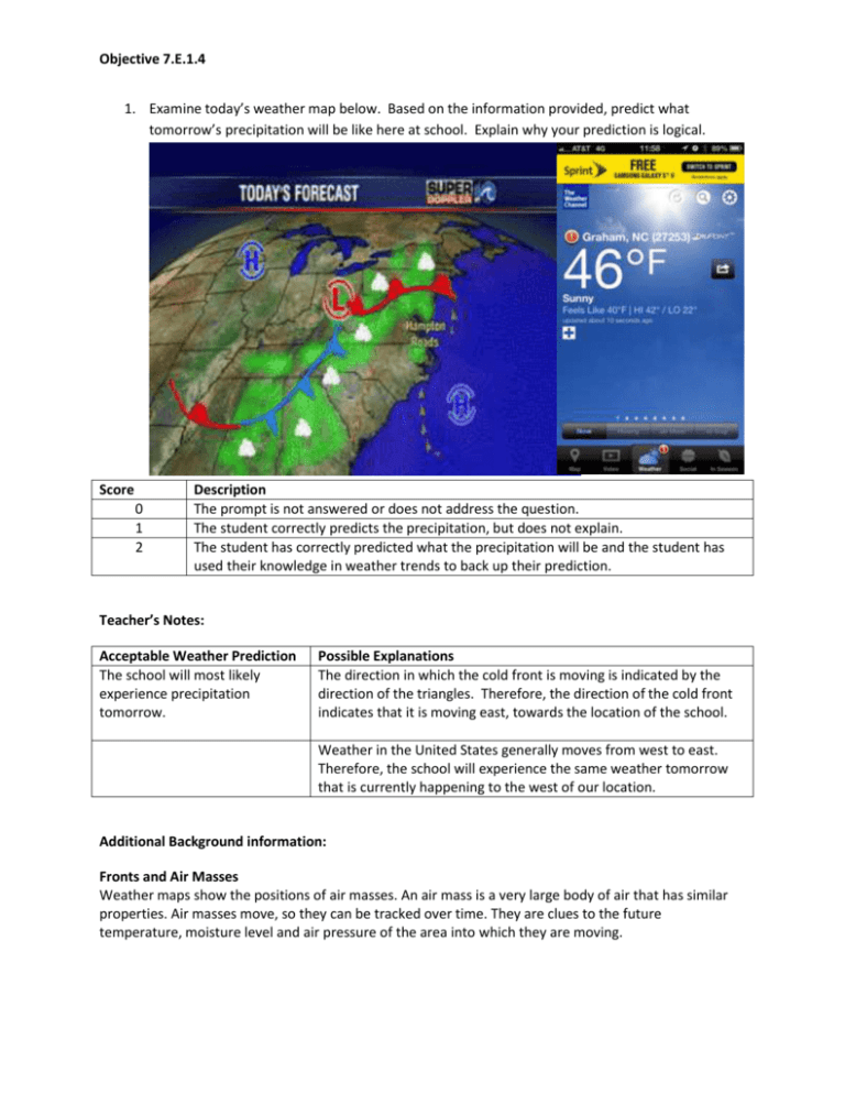
Objective 7.E.1.4 1. Examine today’s weather map below. Based on the information provided, predict what tomorrow’s precipitation will be like here at school. Explain why your prediction is logical. Score 0 1 2 Description The prompt is not answered or does not address the question. The student correctly predicts the precipitation, but does not explain. The student has correctly predicted what the precipitation will be and the student has used their knowledge in weather trends to back up their prediction. Teacher’s Notes: Acceptable Weather Prediction The school will most likely experience precipitation tomorrow. Possible Explanations The direction in which the cold front is moving is indicated by the direction of the triangles. Therefore, the direction of the cold front indicates that it is moving east, towards the location of the school. Weather in the United States generally moves from west to east. Therefore, the school will experience the same weather tomorrow that is currently happening to the west of our location. Additional Background information: Fronts and Air Masses Weather maps show the positions of air masses. An air mass is a very large body of air that has similar properties. Air masses move, so they can be tracked over time. They are clues to the future temperature, moisture level and air pressure of the area into which they are moving. Objective 7.E.1.4 When one air mass meets another, the air in different masses usually does not mix because the properties of the air are different. A boundary, or front, forms between the two air masses. Stormy weather often occurs along fronts. Cold Front A cold front forms where a cold air mass moves into a warm air mass. Cold air contracts, becomes more dense, and thus heavier than warm air, so the cold air pushes underneath the warm air. Cumulus clouds and showers or thunderstorms may be scattered along cold fronts. As the front passes, the wind changes direction. Skies begin to clear, and the temperature usually drops. Warm Front A warm front forms where a warm air mass moves into a cold air mass. Because the warm air is less dense, it slides up and over the colder air. At first, cirrus clouds might appear. They may be followed by stratus clouds and some precipitation, either rain or snow. When the front passes, the sky clears and the air pressure rises. Temperatures also rise as warm air replaces cold air. Stationary Front Even though air masses often move, sometimes they don't, resulting in a stationary front. Precipitation and weak winds usually occur in areas with stationary fronts. High and Low Air Pressure Certain weather conditions are associated with high and low pressure systems. High Pressure Areas High pressure areas, or highs, are shown by "H" symbols. In a high pressure system, air pressure is greater than the surrounding areas. This difference in air pressure results in wind, or moving air. In a high pressure area, air is more dense than in areas of lower pressure. The result is that air will move from the high pressure area to an area of less density, or lower pressure. Winds blow away from high pressure areas toward areas having lower air pressure. Low Pressure Areas Low pressure areas, or lows, are shown by "L" symbols. Winds tend to blow into low pressure areas because air, like other gases, moves from areas of higher pressure into areas of lower pressure. As winds blow into a low, the air moves up. This upward flow of air can cause clouds and precipitation to form. Air pressure is measured by barometers. In general, weather will improve when pressure increases and worsen when pressure decreases. Precipitation: Water in the Air Water is one of the few substances that can be found in all three states--solid, liquid and gas--at normal temperatures and pressures. You might not be able to see all the forms of water, but they're there. Objective 7.E.1.4 Precipitation All the forms of water that fall from the air to the earth's surface are called precipitation. Whether the precipitation is snow, rain, sleet or hail depends on the temperature of the air that the water falls through. If the air is above freezing, the precipitation will most likely be rain. If the air is below freezing, the precipitation will most likely be snow. But sometimes, different temperature layers exist within the air through which the water is falling. For example, if snow falling from a high cloud passes through a warmer layer, then it could melt into rain. But if the rain passes through yet another layer that's colder near the ground, then it becomes sleet. Hail is also the result of water passing through different temperature layers.
