E. tropical rainforest climate a tropical climate usually
4 The climates in the USA 10 vragen
4.1 Find the 5 main climates of the USA on this website and write these down.
(>6= + Marine West Coast)
( http://www.okatlas.org/okatlas/weather/climate/usa/climate.gif)
Cfa) Humid Subtropical
(Dfa) Humid Continental cool summer
(Dfa) Humid Continental warm summer
(h) Highland
(Bsh, Bsk) Subtropical & Midlatitude Steppe
4.2 In America, there are 2 areas (>1) that have a tropical climate. Look at the website and write the names of these 2 states down.
(Aw) Tropical Savanna : Miami
(The map koeppen classification of CLIMATE TYPES says there is only 1 state with a tropical climate.)
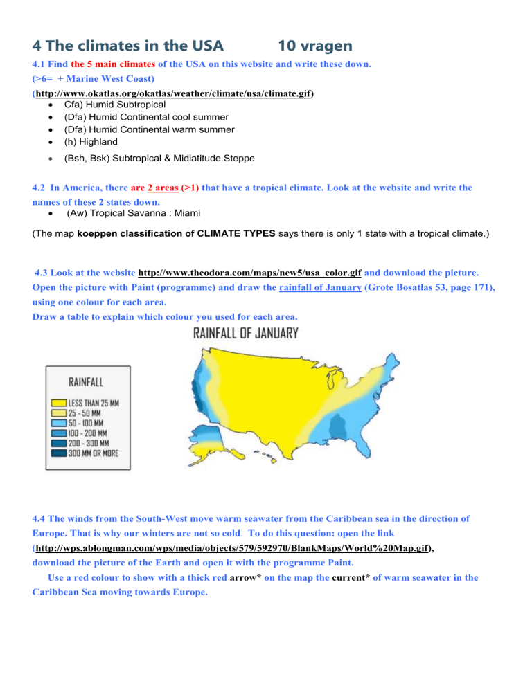
4.3 Look at the website http://www.theodora.com/maps/new5/usa_color.gif
and download the picture.
Open the picture with Paint (programme) and draw the rainfall of January (Grote Bosatlas 53, page 171), using one colour for each area.
Draw a table to explain which colour you used for each area.
4.4 The winds from the South-West move warm seawater from the Caribbean sea in the direction of
Europe. That is why our winters are not so cold . To do this question: open the link
( http://wps.ablongman.com/wps/media/objects/579/592970/BlankMaps/World%20Map.gif), download the picture of the Earth and open it with the programme Paint.
Use a red colour to show with a thick red arrow* on the map the current* of warm seawater in the
Caribbean Sea moving towards Europe.
4.5 What is the name of this ocean current in your atlas? Look at the red arrows.
Use the Bosatlas (53th Edition) to find out. Look in the word register for: "Golfstroom"
Warme Golfstroom
4.6 At what temperature is it too cold for trees to grow at all? ( Read the text)
In the summer they need to be at least 10 degrees C.
4.7 Which trees can live in cold climates most easily? (Read the text)
Needle-leaved trees and birches can live in cold climates.
4.8 Search on the internet for the following climates very carefully before answering the following questions. Describe in short and in your own words:
A. oceanic climate
Soft winters cool summers and it rains through the year.
B. polar / arctic climate
A larger part of the year it is below zero.
C. land climate
Cold winters and hot summers.
D. desert climate this climate usually experiences less than 250 mm (10 inches) per year of precipitation and in some years may experience no precipitation at all. In some instances, an area may experience more than 250 mm of
precipitation annually, but is considered a desert climate because the region loses more water via evapotranspiration than falls as precipitation
E. tropical rainforest climate a tropical climate usually (but not always) found along the equator . Regions with this climate typically feature tropical rainforests , and is designated by the Köppen climate classification as "Af."
4.9 Climate graphs: look at the example of De Bilt.
The graph shows the rainfall and the temperature for each month.
Below you see the rainfall and temperature for New York and Las Vegas.
Make two climate graphs: for for New York and for Las Vegas.
Download and open the excel document; follow the instructions.
4.9 Climate graphs New York + Las Vegas 3.xls
In the winter in New York is colder than in De Bilt and the rainfall is more in New York than in De Bilt.
