Plate Tectonic Vocabulary and notes0
advertisement
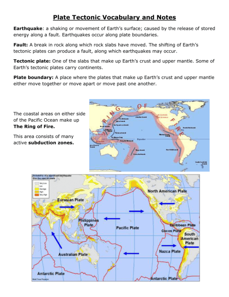
Plate Tectonic Vocabulary and Notes Earthquake: a shaking or movement of Earth’s surface; caused by the release of stored energy along a fault. Earthquakes occur along plate boundaries. Fault: A break in rock along which rock slabs have moved. The shifting of Earth’s tectonic plates can produce a fault, along which earthquakes may occur. Tectonic plate: One of the slabs that make up Earth’s crust and upper mantle. Some of Earth’s tectonic plates carry continents. Plate boundary: A place where the plates that make up Earth’s crust and upper mantle either move together or move apart or move past one another. The coastal areas on either side of the Pacific Ocean make up The Ring of Fire. This area consists of many active subduction zones. Theory of continental drift: A theory that states that the continents were a single landmass at one time in the past, and have moved over time to their present positions. The theory of continental drift was first suggested by Alfred Wegener. *note, this is not the first time the continents had been together in one landmass. Pangaea: the name given to the last supercontinent that existed over 250 million years ago. Evidence pointing towards the Continental Drift Theory are; the shape of the continents and how they seem to fit together like puzzle pieces, the finding of fossils of the same animals but on different continents, the same geological (landmass) features on facing coastlines of separated continents and lastly, climate similarities found in areas that were once connected. See examples of this below. 1. Pieces fitting together: 2. Same types of fossils found on separate continents: 3.Geologic Evidence Similarities „ The age and type of rocks are similar in the coastal regions: Rock samples taken from along the coastline of Africa are similar in age and type to the samples taken from South America. In the picture to the left, the age and structure of the Appalachians (in the Eastern U.S.) is similar to mountains in Greenland and Northern Europe, and the Caledonians of Britain and Norway are very similar (folded mtns.) and are also similar in age. When we fit Europe and North America together, we find that The Appalachians and Caledonides form a single mountain chain. 4. Climate evidence: Below shows how the continents slowly shifted to present day positions: Theory of plate tectonics: The theory that Earth’s lithosphere and crust is broken into enormous slabs, or plates, that are in motion. Scientists use the theory of plate tectonics to explain how Earth’s continents drift. Convection currents in the magma drive the movement of plates! Earth Layers: Crust: The thin, rocky outer layer of Earth. The layer we live on. Under the oceans the crust can be as thin as 10 km (6miles) and where there are mountains the crust can be as thick as 65 km (40 miles). Mantle: The layer of the Earth between the crust and the core. The mantle is the thickest layer of the Earth (2,900 km or 1,740 miles) Lithosphere: The rigid, rocky layer of Earth found in the lower crust and the upper most portion of the mantle. The lithosphere is about 100 km (60 miles). Asthenosphere: The region of the mantle just below the lithosphere. It is the upper part of the mantle that is hot, partially melted, slightly fluid and is able to flow. Core: The innermost, densest layer of Earth. The core is made up of two parts, the outer core and the inner core. The outer core is molten and is made up of iron and some less dense material. The inner core is solid and is mostly iron and possibly some nickel. Convection current: The pathway along which energy travels through a fluid or gas. Heat rises, cools and sinks. This is a continuous cycle. This causes plate movement! Types of Boundaries: Convergent boundary: A place where the plates that make up Earth’s crust and upper mantle collide or come together. Layers of rock may bend or break at a convergent boundary. Subduction: The process of moving part of the lithosphere down into the mantle along a convergent boundary. Divergent boundary: A place where the plates that make up Earth’s crust and upper mantle move away from one another. Most divergent boundaries are found on the ocean floor. Transform-fault boundary: A place where the plates that make up Earth’s crust and upper mantle move past one another. This picture shows the 3 types of boundaries again: A. Makes ridges And rift valley. B. Makes trenches And volcanic Mountains. C. Makes trenches And mountain Ranges. D. Can have Fault Lines visible on surface. Distorts current landforms. Sea floor spreading: The process by which new ocean floor is continually being formed as magma rises to the surface and hardens into rock. Sea-floor spreading occurs as magma fills the space between separating plates. Mid-ocean ridge: A chain of mountains on the ocean floor. New ocean floor forms at the mid- ocean ridge where the sea floor is spreading. Forms at a divergent boundary. Trench: Very narrow and deep area created when one plate is subducting under another. Magma: The hot, molten rock deep inside Earth. Lava: Magma that flows out onto Earth’s surface from a volcano. Rifting: The process by which magma rises to fill the gap between two plates that are moving apart. Rifting in eastern Africa may split the continent into two parts. Geothermal energy: Energy derived from the heat of Earth’s interior. Sediment: Earth material, such as soil and rock fragments formed by weathering. Seismograph: An instrument that records the intensity, duration, and nature of earthquake waves. Check this out!!! You asked why are there so many earthquakes around Japan????

