Assessment- Natural Hazards Report
advertisement
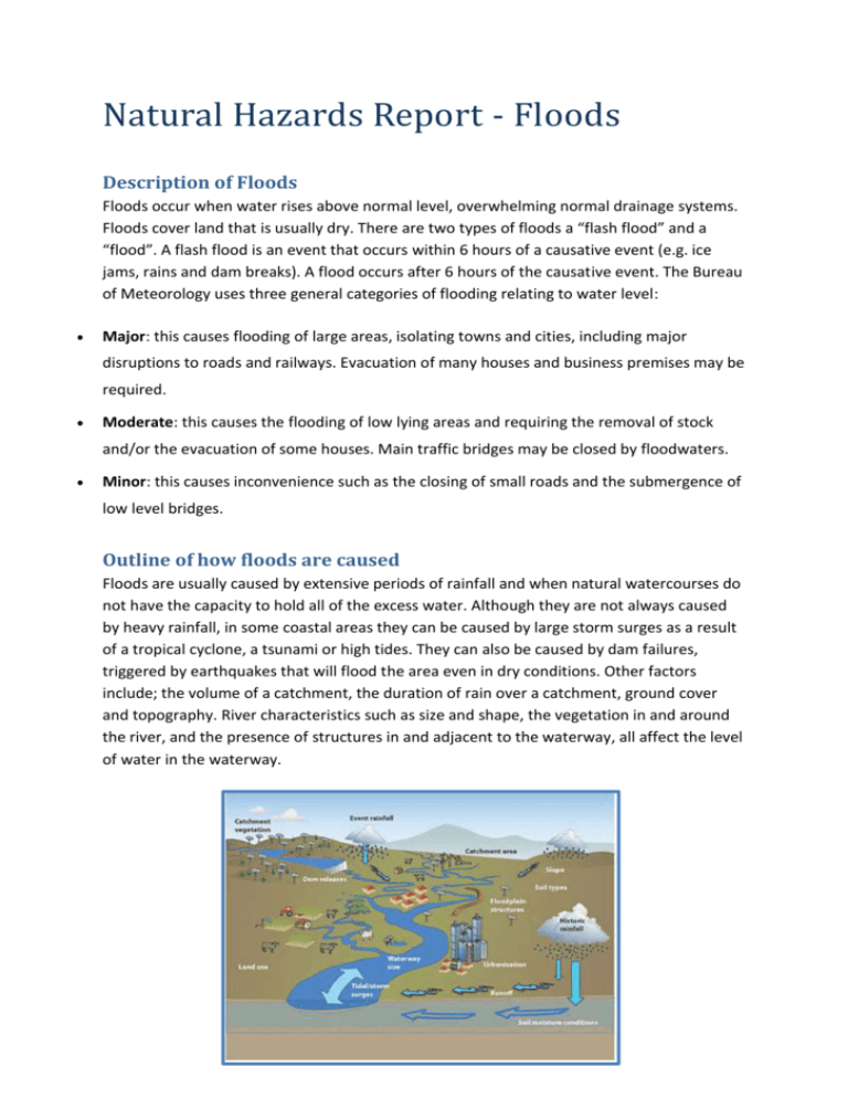
Natural Hazards Report - Floods Description of Floods Floods occur when water rises above normal level, overwhelming normal drainage systems. Floods cover land that is usually dry. There are two types of floods a “flash flood” and a “flood”. A flash flood is an event that occurs within 6 hours of a causative event (e.g. ice jams, rains and dam breaks). A flood occurs after 6 hours of the causative event. The Bureau of Meteorology uses three general categories of flooding relating to water level: Major: this causes flooding of large areas, isolating towns and cities, including major disruptions to roads and railways. Evacuation of many houses and business premises may be required. Moderate: this causes the flooding of low lying areas and requiring the removal of stock and/or the evacuation of some houses. Main traffic bridges may be closed by floodwaters. Minor: this causes inconvenience such as the closing of small roads and the submergence of low level bridges. Outline of how floods are caused Floods are usually caused by extensive periods of rainfall and when natural watercourses do not have the capacity to hold all of the excess water. Although they are not always caused by heavy rainfall, in some coastal areas they can be caused by large storm surges as a result of a tropical cyclone, a tsunami or high tides. They can also be caused by dam failures, triggered by earthquakes that will flood the area even in dry conditions. Other factors include; the volume of a catchment, the duration of rain over a catchment, ground cover and topography. River characteristics such as size and shape, the vegetation in and around the river, and the presence of structures in and adjacent to the waterway, all affect the level of water in the waterway. Location of the Queensland Floods 2010-2011 One of the towns badly affected by the floods was Rockhampton. Location: 23.3750° S, 150.5117° E Distance from Brisbane: 615 km and 8.5 hours’ drive. Distance from Gladstone: 117 km and 1.5 hours’ drive. Altitude/ Height above sea level: 13.4 m Relation between landform, climate and Queensland floods There was mainly one factor influencing the floods in Rockhampton which was high precipitation. In Queensland, the average annual rainfall ranges from very low values in the southwest to very high values along the coast. Rockhampton is located along the coast of Australia meaning it gets a large amount of rainfall each year. Rockhampton is the largest urban centre in central Queensland; it is built adjacent to the Fitzroy River. The Fitzroy River basin is one of the largest on the east coast of Australia, with a catchment area above Rockhampton of about 140 000 𝑘𝑚2 . Due to its immense size and fan-like shape, the Fitzroy River catchment is capable of producing severe flooding following heavy rainfall events. The years 2010 and 2011 were La Nina years. La Nina causes higher rainfall in Australia because it encourages the formation of low pressure systems. Description of Social, Environmental and Economic Changes The Queensland floods affected the lives of many people. They claimed the lives of 35 people and affected more than 200 000 people. The total cost of damage to public infrastructure reached $6.8 billion. In Australia floods are the most expensive natural disaster. The immediate impacts of the floods were damage to property and infrastructure, loss of livestock, destruction of crops and loss of lives. Damage to infrastructure can have great long- term impacts on supplies of clean water, wastewater treatment, electricity, transport, communication, education and health care. Floods can also traumatise victims and their families for the rest of their lives. The loss of loved ones can impact everybody, including the community, and especially children. Destruction of property, displacement from one’s home, disruptions to businesses and social affairs can cause great stress and some psychological impacts may be long lasting. Floods can also have a huge impact on the environment. Some species thrive while others die. Many species are forced to relocate to higher ground. In the Queensland floods the reptiles and ground dwelling fauna were the worst hit. Also many waterways including the Fitzroy River had been impacted significantly as many had been eroded, contaminated, or littered with debris. The erosion of the river banks was in particular concern for the Fitzroy River’s fresh water turtles. Floods can also have some positive effects on the environment. They play an important role in maintaining key ecosystem functions. They link the river with the land surrounding it, recharge groundwater systems, fill wetlands, move both sediment and nutrients around the landscape into the marine environment and for many species, floods trigger breeding events. These positive environmental impacts can also have benefits on the economy by things such as increased fish production, maintenance of the environment and the recharge of groundwater resources. Evaluation of individuals, groups and government Individuals from all over Australia donated to the Floods and over 55 000 registered volunteers gave up their time to help clean-up from the Queensland Floods. The Australian Defence force was activated immediately after the news of the floods and a relief fund was created. Groups such as the Red Cross worked with the government to assist Queensland residents affected by the floods. The Red Cross opened many evacuation centres and assisted over 14 600 people. They also offered psychological support and helped clean up many streets and homes. The Government invested $5.6 billion dollars in rebuilding flood affected regions. They also sponsored 457 temporary Visa’s given to people who could assist in the clean-up of the floods. The Prime Minister of Australia and Prince William toured flood affected areas and the Queen also made a donation to the flood appeal. New Zealand, the United States and England offered to help if needed. Some Local councils were well prepared and well equipped to cope with the events that confronted them during the floods. For example, because of Rockhampton’s location on the Fitzroy River the council had time to prepare for impending flooding, that isolated the city for weeks, because they predicted the floods. In the future the governments decided that they would create better safety plans for the residents living in hazardous areas. Isabella Cooper
