Ashley Primary School Curriculum Map 2014
advertisement
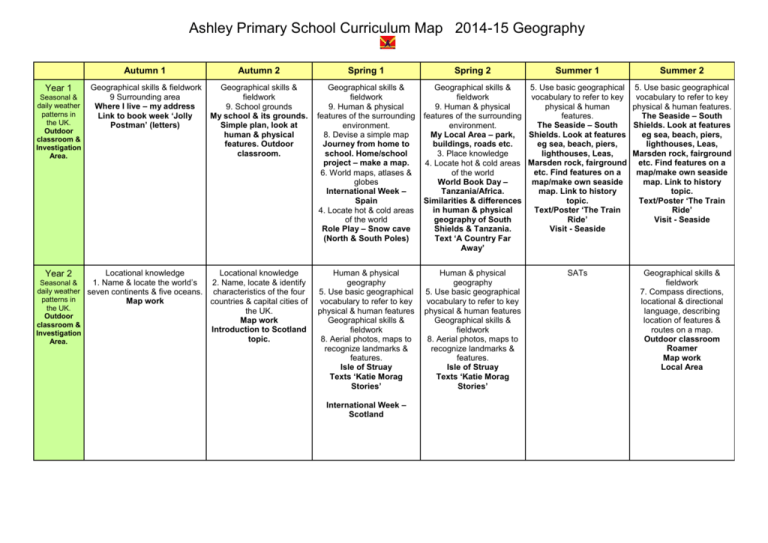
Ashley Primary School Curriculum Map 2014-15 Geography Year 1 Seasonal & daily weather patterns in the UK. Outdoor classroom & Investigation Area. Year 2 Autumn 1 Autumn 2 Spring 1 Geographical skills & fieldwork 9 Surrounding area Where I live – my address Link to book week ‘Jolly Postman’ (letters) Geographical skills & fieldwork 9. School grounds My school & its grounds. Simple plan, look at human & physical features. Outdoor classroom. Geographical skills & fieldwork 9. Human & physical features of the surrounding environment. 8. Devise a simple map Journey from home to school. Home/school project – make a map. 6. World maps, atlases & globes International Week – Spain 4. Locate hot & cold areas of the world Role Play – Snow cave (North & South Poles) Geographical skills & 5. Use basic geographical fieldwork vocabulary to refer to key 9. Human & physical physical & human features of the surrounding features. The Seaside – South environment. My Local Area – park, Shields. Look at features buildings, roads etc. eg sea, beach, piers, lighthouses, Leas, 3. Place knowledge 4. Locate hot & cold areas Marsden rock, fairground etc. Find features on a of the world World Book Day – map/make own seaside Tanzania/Africa. map. Link to history Similarities & differences topic. in human & physical Text/Poster ‘The Train geography of South Ride’ Shields & Tanzania. Visit - Seaside Text ‘A Country Far Away’ Locational knowledge Locational knowledge 2. Name, locate & identify characteristics of the four countries & capital cities of the UK. Map work Introduction to Scotland topic. Human & physical geography 5. Use basic geographical vocabulary to refer to key physical & human features Geographical skills & fieldwork 8. Aerial photos, maps to recognize landmarks & features. Isle of Struay Texts ‘Katie Morag Stories’ Human & physical geography 5. Use basic geographical vocabulary to refer to key physical & human features Geographical skills & fieldwork 8. Aerial photos, maps to recognize landmarks & features. Isle of Struay Texts ‘Katie Morag Stories’ 1. Name & locate the world’s Seasonal & daily weather seven continents & five oceans. patterns in Map work the UK. Outdoor classroom & Investigation Area. International Week – Scotland Spring 2 Summer 1 SATs Summer 2 5. Use basic geographical vocabulary to refer to key physical & human features. The Seaside – South Shields. Look at features eg sea, beach, piers, lighthouses, Leas, Marsden rock, fairground etc. Find features on a map/make own seaside map. Link to history topic. Text/Poster ‘The Train Ride’ Visit - Seaside Geographical skills & fieldwork 7. Compass directions, locational & directional language, describing location of features & routes on a map. Outdoor classroom Roamer Map work Local Area Year 3 5. Human & Physical Geography Volcanoes & Earthquakes Plate tectonics Locating examples Identifying causes and the effect on the area. 7. Maps etc 2. Locational knowledge British Isles Countries & capitals Rivers and mountains 1 Locational knowledge 5 & 6. Human & physical geography 7. Geographical skills International Week France 2. Locational knowledge Counties of the UK – Locate counties and cities of the United Kingdom. Geographical regions – Northumberland? Human & physical characteristics, topographical features, land use patterns & how these have changed over time. Kielder? Northumberlandia Cramlington? 1 Locational knowledge 5 & 6. Human & physical geography 7. Geographical skills International Week Japan 6. Human geography Investigation – Land use (linked to History topic). Mapping skills Examine old colliery sites, eg St.Hildas/commerce, supermarket & business units. Westoe/housing development, shops & school. Monkwearmouth/football ground. Compare old/recent maps. 1 Locational knowledge 5 & 6. Human & physical geography 7. Geographical skills International Week Greece 1 Locational knowledge 4. Place Knowledge Europe Compare area of Europe Locate & name the main (France) with the region countries of Europe & of the UK. their capitals. Longest/highest rivers/mountains – World map. 8. Geographical skills and fieldwork Map Skills – 8 points of a compass 2 figure grid references Map symbols Using/sketching maps Link to Science – Rocks? Link to Romans in History Pompeii Year 4 Year 5 2. Locational knowledge Counties of the North East – Locate and name counties and cities in/around the North East. 7. Geographical skills Map work – Location of industry/ coal fields Link to History topic. 6. Human geography Types of Settlement – How people choose where to settle. Link with History topic Early settlements AngloSaxon. 7. Geographical skills Map Skills – 8 points of a compass 4 – 6 figure grid references. Map symbols revision Thurston/Lake District Physical features Fieldwork - Orienteering 6. Human geography 9. Geographical skills and fieldwork Types of Settlement – Modern settlements Land use Villages, towns & cities Record human and physical features in the local area using a range of methods. 8. Geographical skills and fieldwork Map Skills – 8 points of a compass 4 figure grid references Map symbols revision 5. Physical geography Rivers Topic Rivers and the water cycle Features and development 5. Physical geography Rivers Topic Rivers and the water cycle Features and development Year 6 1 & 3 Locational knowledge World Map – Locate countries of the world Longitude & latitude, Equator etc 7 Geographical skills World Map – Physical features mountain ranges/rivers 1 Locational knowledge 5 & 6. Human & physical geography 7. Geographical skills International Week - India SATs 4. Place knowledge 5. Physical geography 6. Human geography Rainforests Topic South America Compare UK with South America Climate zones, biomes, vegetation belts & rivers. Impact of logging, farming & mining on the rainforests. Fair Trade Trade between the UK and the rest of the world. Look at fair trade products. Literacy links - role play looking at different arguments for changing land use in the rainforest or a fair-trade campaign.
