12.2-notes
advertisement
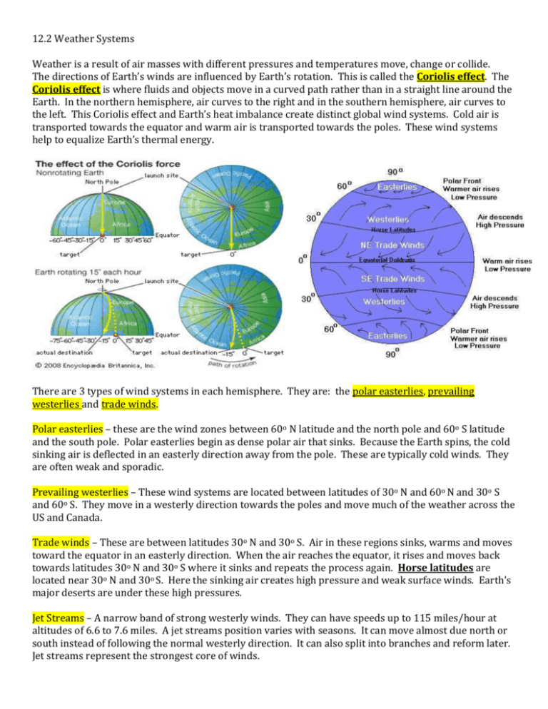
12.2 Weather Systems Weather is a result of air masses with different pressures and temperatures move, change or collide. The directions of Earth’s winds are influenced by Earth’s rotation. This is called the Coriolis effect. The Coriolis effect is where fluids and objects move in a curved path rather than in a straight line around the Earth. In the northern hemisphere, air curves to the right and in the southern hemisphere, air curves to the left. This Coriolis effect and Earth’s heat imbalance create distinct global wind systems. Cold air is transported towards the equator and warm air is transported towards the poles. These wind systems help to equalize Earth’s thermal energy. There are 3 types of wind systems in each hemisphere. They are: the polar easterlies, prevailing westerlies and trade winds. Polar easterlies – these are the wind zones between 60o N latitude and the north pole and 60o S latitude and the south pole. Polar easterlies begin as dense polar air that sinks. Because the Earth spins, the cold sinking air is deflected in an easterly direction away from the pole. These are typically cold winds. They are often weak and sporadic. Prevailing westerlies – These wind systems are located between latitudes of 30o N and 60o N and 30o S and 60o S. They move in a westerly direction towards the poles and move much of the weather across the US and Canada. Trade winds – These are between latitudes 30o N and 30o S. Air in these regions sinks, warms and moves toward the equator in an easterly direction. When the air reaches the equator, it rises and moves back towards latitudes 30o N and 30o S where it sinks and repeats the process again. Horse latitudes are located near 30o N and 30o S. Here the sinking air creates high pressure and weak surface winds. Earth’s major deserts are under these high pressures. Jet Streams – A narrow band of strong westerly winds. They can have speeds up to 115 miles/hour at altitudes of 6.6 to 7.6 miles. A jet streams position varies with seasons. It can move almost due north or south instead of following the normal westerly direction. It can also split into branches and reform later. Jet streams represent the strongest core of winds. A collision of two air masses forms a Front - a narrow region between two air masses with different densities. Cold front – Cold, dense air forces the warm air, which is less dense up. As the warm air rises, it cools and condenses. Intense precipitation (heavy rain/snow) and sometimes thunderstorms are common. The triangles point in the direction of the front’s movement. symbol ________________________________________________________________________________________________________________________ Warm front – Warm air displaces cold air and can cause light precipitation or drizzly rain. Red semicircles point in the direction of the front’s movement. symbol _________________________________________________________________________________________________________________________ Stationary front – When two air masses meet but neither advances, the boundary between them stalls. There can be light winds and precipitation. The wet weather can last for several days. Alternating cold and warm front symbols pointing in opposite directions represents this. symbol Occluded front - Sometimes a cold air mass moves so rapidly that it overtakes a warm front and forces the warm air upward. As the warm air is lifted, the advancing cold air mass collides with the cold air mass in front of the warm front. Strong winds and a lot of precipitation are common. This front is represented by purple triangles and semicircles pointing in the direction of the front’s movement. Symbol Pressure systems – High-pressure areas have sinking air, and low-pressure areas have rising air. Air always flows from an area of high pressure to an area of low pressure. Low-pressure systems – Air rises here. When air outside the pressure system replaces the rising air, the air spirals inward toward the center and then upward. In the northern hemisphere, the lowpressure system moves counter clockwise. In the southern hemisphere, it moves clockwise. As the air rises, it cools and condenses into clouds and creates cloudy weather with precipitation. High-pressure system – Sinking air moves away from the center. In the northern hemisphere, the highpressure system moves clockwise and in the southern hemisphere, it moves counter clockwise. Highpressure systems are usually associated with fair weather. These are common in the subtropical oceans on Earth.
