The Coastal Plains of Virginia
advertisement
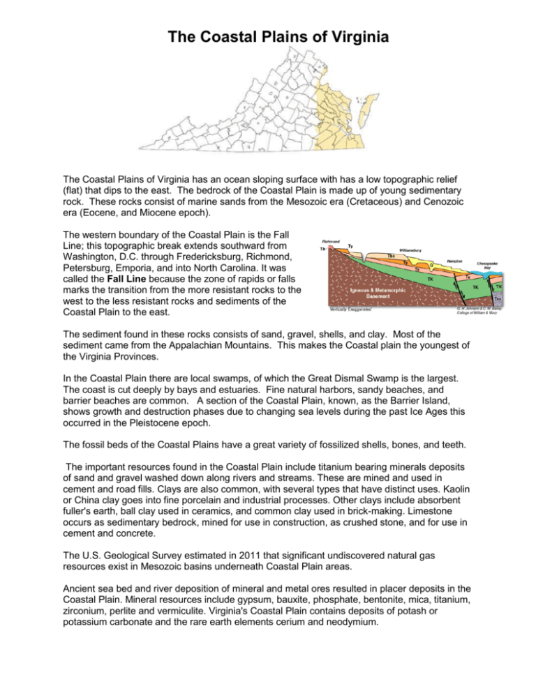
The Coastal Plains of Virginia The Coastal Plains of Virginia has an ocean sloping surface with has a low topographic relief (flat) that dips to the east. The bedrock of the Coastal Plain is made up of young sedimentary rock. These rocks consist of marine sands from the Mesozoic era (Cretaceous) and Cenozoic era (Eocene, and Miocene epoch). The western boundary of the Coastal Plain is the Fall Line; this topographic break extends southward from Washington, D.C. through Fredericksburg, Richmond, Petersburg, Emporia, and into North Carolina. It was called the Fall Line because the zone of rapids or falls marks the transition from the more resistant rocks to the west to the less resistant rocks and sediments of the Coastal Plain to the east. The sediment found in these rocks consists of sand, gravel, shells, and clay. Most of the sediment came from the Appalachian Mountains. This makes the Coastal plain the youngest of the Virginia Provinces. In the Coastal Plain there are local swamps, of which the Great Dismal Swamp is the largest. The coast is cut deeply by bays and estuaries. Fine natural harbors, sandy beaches, and barrier beaches are common. A section of the Coastal Plain, known, as the Barrier Island, shows growth and destruction phases due to changing sea levels during the past Ice Ages this occurred in the Pleistocene epoch. The fossil beds of the Coastal Plains have a great variety of fossilized shells, bones, and teeth. The important resources found in the Coastal Plain include titanium bearing minerals deposits of sand and gravel washed down along rivers and streams. These are mined and used in cement and road fills. Clays are also common, with several types that have distinct uses. Kaolin or China clay goes into fine porcelain and industrial processes. Other clays include absorbent fuller's earth, ball clay used in ceramics, and common clay used in brick-making. Limestone occurs as sedimentary bedrock, mined for use in construction, as crushed stone, and for use in cement and concrete. The U.S. Geological Survey estimated in 2011 that significant undiscovered natural gas resources exist in Mesozoic basins underneath Coastal Plain areas. Ancient sea bed and river deposition of mineral and metal ores resulted in placer deposits in the Coastal Plain. Mineral resources include gypsum, bauxite, phosphate, bentonite, mica, titanium, zirconium, perlite and vermiculite. Virginia's Coastal Plain contains deposits of potash or potassium carbonate and the rare earth elements cerium and neodymium. The Piedmont Province of Virginia The largest of the provinces, the Piedmont, is directly west of the Coastal Plain and literally means “foot of the hill” because the Blue Ridge, the highest mountains, is directly west. The Piedmont covers the middle one-third of the state. The Piedmont is an area of rolling landscape – gentle hills and valleys with a few isolated mountains made of more resistant rocks. The dominant rocks found in the province are Precambrian and Paleozoic metamorphic and igneous rocks. Examples of these rocks include slates, marbles, granite and quartzite. There are some Triassic sedimentary rocks. The Piedmont is characterized by deep weathered, very old erosion surface. It widens from the northwest to the southwest, from 30 miles on the Maryland border to about 160 miles at the North Carolina line. Elevation is from 1000-1300 feet to 200 feet at the Fall Line. The basins contain unmetamorphosed sandstone and shale where dinosaur tracks have been preserved. Important resources include gold, pyrite, and slate. Some coal and methane are also found here. The Piedmont hosts one of the world's largest kyanite mines at Willis Mountain in Buckingham County. Kyanite is used primarily in ceramic products, including porcelain plumbing fixtures and dishware. It is also used in electronics, electrical insulators and abrasives. The Blue Ridge Mountains Province of Virginia The Blue Ridge is a long narrow area extending from southwest Virginia through the westcentral portion through the north-central part of the state. It has the highest peaks in the state. These mountains are made of Precambrian aged metamorphosed rock as well as ancient lava flows. The rugged and weathered rock has undergone extreme faulting and folding. The Blue Ridge is divided into two distinct parts: 1. Northeast of Roanoke – Very narrow (less than 2 miles across in some places like Afton Mountain on I-64), fairly rugged and reaches 4100 feet near Luray. 2. Southwest of Roanoke – Here the Blue Ridge broadens into very high mature erosion surfaces up to 50 miles wide. On the surface are peaks such as Mt. Rogers (5719 feet and the highest), Whitetop Mountain, and Peaks of Otter. Regionally, the Blue Ridge extends from Northwest Georgia to South-central Pennsylvania with the widest part in eastern Tennessee to western North Carolina, and is called the Great Smokies. The Blue Ridge contains mainly granite, gneiss, and metamorphosed igneous and sedimentary rocks. They are very hard and resistant rocks and create the highest area in Virginia. Blue Ridge rocks are quarried for quartzite as crushed stone and, in the past, mining occurred for copper, iron, manganese, turquoise, and a limited amount of tin. The Valley and Ridge Province of Virginia The Valley and Ridge covers the western part of Virginia, from the Tennessee border to Maryland – West Virginia. It consists of long, linear ridges (some greater than 4000 feet above sea level) with well-defined long linear valleys in between. Trending northwest to southwest, the Valley and Ridge is bounded by the Blue Ridge and the Plateau. Its long valley runs the length of the province on the eastern border adjacent to the Blue Ridge and is known as the Shenandoah Valley in northern Virginia, but it is generally called the Great Valley. This province is composed of folded and faulted 550 to 300 million-year-old sedimentary rocks (Paleozoic-age). Most ridges are held up by resistant sandstone, and most valleys are underlain by less resistant shale, limestone, and dolostone. Underlain by mostly carbonate rocks, the valley of this province is a region of Karst. Solution of the carbonate bedrock has created sinkholes on the surface and many caves and large caverns beneath the surface. Resources currently extracted from this province are limestone, sandstone, gypsum, iron oxides, clay, oil, natural gas, and shale. The Appalachian Plateau Province of Virginia In Virginia, the Appalachian Plateau province encompasses only the southwestern counties and includes the Southwest Virginia coal field. This province contains a portion of the Cumberland Plateau and is characterized by deep narrow valleys and steep, rugged mountainsides. This province generally contains 320 to 280 million-year-old sandstone (Paleozoic-aged) and shale formations with coal beds. The rocks in this province have not been deformed as in the Valley and Ridge and still occur today in horizontal beds. Regionally, the Plateau extends from Alabama to New York. The Appalachian Plateau is rich in mineral resources such as coal, natural gas, petroleum. Name: ______________________________ Mineral Resources of Virginia Mineral Resources Uses Carbonates Manufacture of lime (CaO) Manufacture of cement Agricultural uses Steel making Crushed stone (construction, *aggregate) Clay China an ceramics Filler and surface coating for paper Making bricks, drain pipes, and cements Coal Electric production Industrial uses Coke (not the drink, man-made coal) Residential and commercial uses Residential, commercial, and industrial uses Jewelry, etc. Construction as *aggregate in concrete, as road base, or as fill. Gas and Oil Gold Sand and Gravel Major Province Where Found *Aggregate is gravel to sand size rock material. Sand and gravel are the most used aggregates. Where the supply of sand and gravel is insufficient quantity or quality, aggregates are produced by crushing and sorting the rocks by size. Name: _____________________________ Virginia Geology Analysis Table Refer to your geologic Map of Virginia and Reference sheet to fill in the chart below. Province Era Period Age* Coastal Plain Piedmont Blue Ridge Mountains Valley & Ridge Appalachian Plateau *Age may vary slightly depending on the geologic map/time scale used. Rock Type Name: ________________________ Date: ____________ Checking for Understanding Using the map below and the space provided, identify and label the five physiographic provinces of Virginia. 1. _______________________________ 2. _______________________________ 3. _______________________________ 4. _______________________________ 5. _______________________________ 6. Which physiographic province of Virginia is generally flat, has terraced landscape and contains sand, gravel, and clay as some economically important minerals? 7. Which physiographic province of Virginia is associated with Karst (cave, sinkholes, disappearing streams, limestone) topography? 8. Which physiographic province of Virginia is rich in mineral resources such as petroleum, coal, and natural gas? 9. Which physiographic province of Virginia contains Virginia’s highest mountain (Mount Rodgers)? 10. List three differences between the Mesozoic and the Cenozoic Eras. 11. These geologic events occurred over time, with each having a casual effect on the next. Number them in the sequence in which they occurred, keeping in mind which caused which. ________ The Appalachian Mountains rose on Earth’s surface. ________ Heat rose from Earth’s core. ________ The North American and African continents collided (converged). ________ Convection cells were created in the asthenosphere. ________ The North American and African lithospheric plates moved. 12. Where is the youngest rock/sediment in Virginia located? List age and Province 13. Where is the oldest rock located? List age and Province 14. Where in Virginia are coal deposits found? List ages and provinces. 15. Describe the environment of the existed in the Valley and Ridge province during the late Paleozoic? 16. Which province would you most likely find fossils of ancient marine animals preserved in rock? Why? 17. How does the rock composition of the Blue Ridge Mountains differ from the ridges in the Valley and ridge Province? 18. Explain why we refer to the Valley and Ridge as having Karst topography? Be sure to include the types of rock and features associated with Karst.

