Igneous intrusive rocks
advertisement

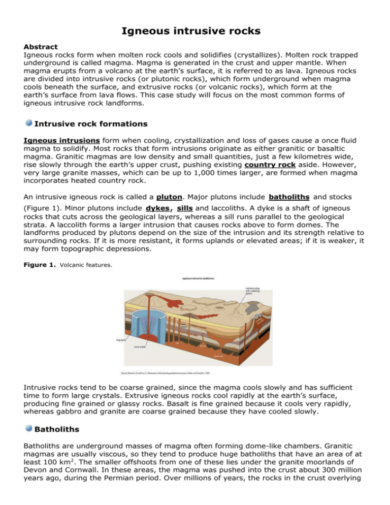
Igneous intrusive rocks Abstract Igneous rocks form when molten rock cools and solidifies (crystallizes). Molten rock trapped underground is called magma. Magma is generated in the crust and upper mantle. When magma erupts from a volcano at the earth’s surface, it is referred to as lava. Igneous rocks are divided into intrusive rocks (or plutonic rocks), which form underground when magma cools beneath the surface, and extrusive rocks (or volcanic rocks), which form at the earth’s surface from lava flows. This case study will focus on the most common forms of igneous intrusive rock landforms. Intrusive rock formations Igneous intrusions form when cooling, crystallization and loss of gases cause a once fluid magma to solidify. Most rocks that form intrusions originate as either granitic or basaltic magma. Granitic magmas are low density and small quantities, just a few kilometres wide, rise slowly through the earth’s upper crust, pushing existing country rock aside. However, very large granite masses, which can be up to 1,000 times larger, are formed when magma incorporates heated country rock. An intrusive igneous rock is called a pluton. Major plutons include batholiths and stocks (Figure 1). Minor plutons include dykes, sills and laccoliths. A dyke is a shaft of igneous rocks that cuts across the geological layers, whereas a sill runs parallel to the geological strata. A laccolith forms a larger intrusion that causes rocks above to form domes. The landforms produced by plutons depend on the size of the intrusion and its strength relative to surrounding rocks. If it is more resistant, it forms uplands or elevated areas; if it is weaker, it may form topographic depressions. Figure 1. Volcanic features. Intrusive rocks tend to be coarse grained, since the magma cools slowly and has sufficient time to form large crystals. Extrusive igneous rocks cool rapidly at the earth’s surface, producing fine grained or glassy rocks. Basalt is fine grained because it cools very rapidly, whereas gabbro and granite are coarse grained because they have cooled slowly. Batholiths Batholiths are underground masses of magma often forming dome-like chambers. Granitic magmas are usually viscous, so they tend to produce huge batholiths that have an area of at least 100 km2. The smaller offshoots from one of these lies under the granite moorlands of Devon and Cornwall. In these areas, the magma was pushed into the crust about 300 million years ago, during the Permian period. Over millions of years, the rocks in the crust overlying the batholith complex have been worn away, exposing the granites at the surface. Since these granites are hard and resistant, they have been eroded more slowly than the surrounding sedimentary rocks, forming the upstanding moorlands. However, some weaknesses and cracks do exist in the granites, and these help to explain the development of parts of the landscape known as tors. The cracks were created by contraction as the magma cooled, and by the release of pressure on the granite as the overlying crustal rocks were removed by erosion. Figure 2. Dartmoor Tor. Skaergaard batholith The Skaergaard intrusion in eastern Greenland is a layered intrusion of gabbro, formed some 60 million years ago. Skaergaard is the world’s most intensively studied large igneous body. Where it is exposed at the surface, the intrusion is about 10 km wide. It is notable for its vast sequence of layered rocks that were formed by differentiation of a mass of basaltic magma. Crystals of dense, silicate minerals sank through the liquid remnants of the original magma, but were interrupted by convection currents. When this happened, the magma composition changed, with bands of rock forming from different minerals as the layers accumulated and cooled progressively. Figure 3. Yes Tor in Dartmoor. Figure 4. Granite rock in Dartmoor. Half Dome, Yosemite, Sierra Nevada Half Dome is a granodiorite batholith formed about 80 million years ago. Like all batholiths, the Sierra Nevada is not formed from a single type of granite. It consists of a series of intrusions that were emplaced over 50 million years during the Cretaceous period, when the region sat above an active convergent plate boundary. Half Dome is Yosemite’s steepest wall (Figures 5 and 6), with few weaknesses, as is typical of the largest batholiths. Figure 5. The steep wall at Half Dome, Yosemite. Figure 6.The granodiorite batholith at Yosemite. Sugar Loaf Mountain, Rio de Janeiro The Sugar Loaf is a solid granite batholith formed some 800 million years ago. It is a tiny part of a huge batholith that stretches along the Brazilian coast on either side of Guanabara Bay. It was formed by the partial melting of lava at the centre of a plate convergence zone that was active about 800 million years ago in late Precambrian times. Since then, erosion has left stumps of granite that form the magnificent peaks around Rio de Janeiro. Tors on Dartmoor and Bodmin Moor Although resistant, granite is not immune from the effects of weathering and erosion. It contains many joints and other lines of weakness, and weathering and erosion mainly occur at these sections. These joints, together with their variable spacing, give rise to one of the most striking features of Dartmoor – tors (Figures 2 and 3). The origin of the tors has been long debated. According to the geomorphologist David Linton, tors develop in two stages. Firstly, intensive rotting of the granite in warm conditions produces rounded boulders set in a mass of decomposed rock known as growan. Secondly, the removal of the growan exposes the rounded boulders that make up the tors. Alternatively, tors may be formed by severe frost weathering in periglacial periods. Areas of close jointing would be severely attacked by the frost, whereas rock where the jointing was less dense would be little affected. Removal of the frost-shattered debris would leave the coarse-jointed rock masses as upstanding tors. Sills and dykes Basaltic magmas are fluid, so either they flow into thin gaps and cool vertically as dykes that run through the rock strata, or they set horizontally as sills along bedding planes. Because rock cools more slowly underground than it does on the surface, the rocks that form igneous intrusions have larger crystals than those formed when lava solidifies at the surface. Rocks that form dykes are medium-grained and are usually dolerite, whereas those that form larger intrusive bodies, such as batholiths and stocks, are coarse-grained gabbro or granite. Ring dykes, shaped like vertical tubes, are formed as magma fills cracks created by upward pressure. The igneous rocks formed as the magma cools are usually relatively resistant and, after erosion, they stand out in the landscape. Much of Hadrian’s Wall was built along part of a giant sill complex – the Great Whin Sill – that also features waterfalls further south. Ardnamurchan This is a gabbro ring dyke complex, formed about 60 million years ago. A decline in pressure over a large magma chamber caused conical fractures to form. Magma intruded into these fissures to form dykes. Subsequent cone-shaped sheet intrusions then formed when magma pressure increased. Above these deep intrusions, huge volcanic craters erupted lavas and pyroclastic deposits. Mackenzie Dykes Hundreds of parallel intrusions form the largest dyke swarm in the world, located in the icescoured lowlands of the Canadian Shield. These dykes formed when magma intruded into fissures that opened along a zone of tension above an active mantle plume. Figure 7. Part of Hadrian’s Wall is built on top of the Great Whin Sill. The Great Whin Sill The Great Whin Sill in Northumberland is a narrow ridge of hard, dark-coloured rock called dolerite. Hadrian’s Wall was built, in part, along the sill (Figure 7), as it offered extra protection against attack. Dolerite is formed when molten magma is pushed up into the crust and it cools and solidifies. In this case, the magma was pushed between layers of carboniferous limestones, sandstones and shales to form a thin sheet of rock called a sill. As the intrusive magma cooled, it contracted, forming the characteristic joints in the rock. The intrusion is complex, cutting across layers of sediments to form sheets at multiple levels. It appears to have been fed by more than one chamber. Whin Sill is therefore not a single sill but a collection of cross-cutting sills and flat, lens-shaped intrusions. Since the intrusion, the carboniferous rocks and the dolerite have been gently tilted. The Whin Sill extends over a large area from Middleton in Teesdale in the south to Bamburgh in the north and is responsible for other natural features in the area. It varies from 30 m to about 60 m in thickness, and gradually thins as it goes westwards. However, in most places the sill of dolerite is not seen on the surface of the ground, but remains covered by the carboniferous rocks. It has been exposed in a few areas by the erosion of overlying rocks, especially the weak shale bands. Thus, the hard and tough dolerite, which is very resistant to erosion, stands out as ridges in the landscape. In places, it also helps form islands, such as the Farne Islands, and also forms the base for the castle at Holy Island (Figure 8).Figure 8. The castle at Holy Island. The Great Whin Sill is also responsible for one of Britain’s most famous waterfalls, High Force, where the River Tees falls for 20 m. Two types of rock can be seen at the falls. The lower rock has horizontal layers and it forms part of the carboniferous limestone. The upper set of darkcoloured rocks has vertical joints and is much denser and harder than the limestone underneath (Figure 9). Figure 9. The High Force waterfall. Note the dolerite resting on top of the limestone. This tough band of dolerite is resistant to erosion, which explains the location of the waterfall. Where there is no dolerite, the valley broadens out and waterfalls are absent, but other bands of dolerite create waterfalls just a short distance upstream at Cauldron Snout and downstream at Low Force. Volcanic plugs A volcanic plug is an igneous intrusion formed when magma crystallizes within the neck of a volcano. Subsequent weathering and erosion remove the rock comprising the volcano leaving cylindrical plugs that formed from magma that has cooled inside volcanic vents. Devil’s Tower, Wyoming The Devil’s Tower is a volcanic plug, formed of phonolite some 40 million years ago. It originated as a volcanic vent, but subsequent erosion of the surrounding rock has revealed the igneous rock that cooled and solidified underground. The original volcano lost its gas pressure through volcanic explosions through overlying sedimentary rocks, whilst much of the magma remained underground. The underground plug was nearly 300 m in diameter and, as it cooled slowly, the magma contracted and fractured forming near perfect polygonal joints. The tower reaches a height of over 260 m. The phonolite that forms the Devil’s Tower originates from continental crust – it contains small crystals of aegirine but less silica than other rhyolite magmas. Ship Rock Ship Rock is a lampropohyre plug formed some 30 million years ago. Though it now stands 500 m above the surrounding plains, Ship Rock formed underground when magma cooled within the feeder pipes of a volcano. The lavas and pyroclastic deposits of the volcano have since disappeared, and subsequent erosion of the underlying soft shales has steadily lowered the surface of the surrounding plains. The resistant rock of the plug is far less worn, and stands high above the desert. The upper part of Ship Rock is a lava breccia, created when rock was shattered by explosive eruptions within the volcano’s vent. At the time of these eruptions, the rocks that constitute today’s summit were probably less than 1,000 m below the earth’s surface. In addition to feeding the main conduit, magma also ascended into radiating fissures, where it cooled to form the dykes that distinguish Ship Rock. These were exposed as the adjacent surface eroded, resulting in spectacular dyke walls. The rock ribs are about 3 m thick and stand 20 m high. The longest dyke stretches for nearly 3 km. Conclusion All of the igneous intrusive rocks sites mentioned in this case study are very important to the landscape and have great scenic quality, as well as being used for settlement and defence. Many of these sites have economic and social advantages for human activities, and are used in the production of hard rocks and materials for construction and for various industrial activities.


