Hurricanes - Alvin ISD
advertisement
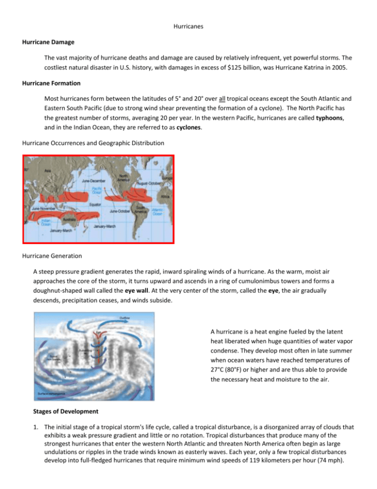
Hurricanes Hurricane Damage The vast majority of hurricane deaths and damage are caused by relatively infrequent, yet powerful storms. The costliest natural disaster in U.S. history, with damages in excess of $125 billion, was Hurricane Katrina in 2005. Hurricane Formation Most hurricanes form between the latitudes of 5° and 20° over all tropical oceans except the South Atlantic and Eastern South Pacific (due to strong wind shear preventing the formation of a cyclone). The North Pacific has the greatest number of storms, averaging 20 per year. In the western Pacific, hurricanes are called typhoons, and in the Indian Ocean, they are referred to as cyclones. Hurricane Occurrences and Geographic Distribution Hurricane Generation A steep pressure gradient generates the rapid, inward spiraling winds of a hurricane. As the warm, moist air approaches the core of the storm, it turns upward and ascends in a ring of cumulonimbus towers and forms a doughnut-shaped wall called the eye wall. At the very center of the storm, called the eye, the air gradually descends, precipitation ceases, and winds subside. A hurricane is a heat engine fueled by the latent heat liberated when huge quantities of water vapor condense. They develop most often in late summer when ocean waters have reached temperatures of 27°C (80°F) or higher and are thus able to provide the necessary heat and moisture to the air. Stages of Development 1. The initial stage of a tropical storm's life cycle, called a tropical disturbance, is a disorganized array of clouds that exhibits a weak pressure gradient and little or no rotation. Tropical disturbances that produce many of the strongest hurricanes that enter the western North Atlantic and threaten North America often begin as large undulations or ripples in the trade winds known as easterly waves. Each year, only a few tropical disturbances develop into full-fledged hurricanes that require minimum wind speeds of 119 kilometers per hour (74 mph). 2. When a cyclone's strongest winds do not exceed 61 kilometers per hour, it is called a tropical depression. 3. When winds are between 61 and 119 kilometers per hour, the cyclone is termed a tropical storm. Wind speeds over 119 kph are categorized as hurricanes. The Saffir-Simpson Scale Although damage caused by a hurricane depends on several factors, including the size and population density of the area affected and the near-shore bottom configuration, the most significant factor is the strength of the storm itself. The Saffir-Simpson scale ranks the relative intensities of hurricanes. It is a 1-5 rating based on the hurricane's present intensity. This is used to give an estimate of the potential property damage and flooding expected along the coast from a hurricane landfall. Wind speed is the determining factor in the scale, as storm surge values are highly dependent on the slope of the continental shelf in the landfall region. Note that all winds are using the U.S. 1minute average. 1. Category One Hurricane: Winds 74-95 mph (64-82 kt or 119-153 km/hr). Storm surge generally 4-5 ft above normal. No real damage to building structures. Damage primarily to unanchored mobile homes, shrubbery, and trees. Some damage to poorly constructed signs. Also, some coastal road flooding and minor pier damage. 2. Category Two Hurricane: Winds 96-110 mph (83-95 kt or 154-177 km/hr). Storm surge generally 6-8 feet above normal. Some roofing material, door, and window damage of buildings. Considerable damage to all things discussed for Category 1 hurricanes. Small craft in unprotected anchorages break moorings. 3. Category Three Hurricane: Winds 111-130 mph (96-113 kt or 178-209 km/hr). Storm surge generally 9-12 ft above normal. Some structural damage to small residences and utility buildings with a minor amount of curtain wall failures. Large trees are often blown down. Major damages/destruction to previously mentioned structures. Flooding near the coast destroys smaller structures with larger structures damaged by battering from floating debris. . Evacuation of low-lying residences with several blocks of the shoreline may be required. 4. Category Four Hurricane: Winds 131-155 mph (114-135 kt or 210-249 km/hr). Storm surge generally 13-18 ft above normal. More extensive curtain wall failures with some complete roof structure failures on small residences. Complete destruction to previously mentioned structures. Extensive damage to doors and windows. Major damage to lower floors of structures near the shore. Terrain lower than 10 ft above sea level may be flooded requiring massive evacuation of residential areas as far inland as 6 miles (10 km). 5. Category Five Hurricane: Winds greater than 155 mph (135 kt or 249 km/hr). Storm surge generally greater than 18 ft above normal. Complete roof failure on many residences and industrial buildings. Some complete building failures with small utility buildings blown over or away. All shrubs, trees, and signs blown down. Complete destruction of mobile homes. Severe and extensive window and door damage. Major damage to lower floors of all structures located less than 15 ft above sea level and within 500 yards of the shoreline. Massive evacuation of residential areas on low ground within 5-10 miles (8-16 km) of the shoreline may be required. Damage Classes Damage caused by hurricanes can be divided into three classes: (1) storm surge, which is most intense on the right side of the eye where winds are blowing toward the shore, occurs when a dome of water 65 to 80 kilometers (40 to 50 miles) wide sweeps across the coast near the point where the eye makes landfall, (2) wind damage, and (3) inland freshwater flooding, which is caused by torrential rains that accompany most hurricanes. Warning Systems North Atlantic hurricanes develop in the trade winds, which generally move these storms from east to west at about 25 kilometers (15 miles) per hour. Today, because of early warning systems that help detect and track hurricanes, the number of deaths associated with these violent storms have been greatly reduced. Because the tropical and subtropical regions that spawn hurricanes consist of enormous areas of open oceans, meteorological data from these vast regions are provided primarily by satellites. Information and Watches Other important sources of hurricane information are: 1. aircraft reconnaissance 2. radar 3. remote, floating instruments called data buoys. Using data from the observational tools, meteorologists can issue an announcement, called a hurricane watch, aimed at specific coastal areas threatened by a hurricane, generally within 36 hours. By contrast, a hurricane warning is issued when sustained winds of 119 kilometers per hour (74 mph) or higher are expected within a specified coastal area in 24 hours or less. Two important factors in the watch-and warning decision process are: (1) adequate lead time (2) attempting to keep over-warning at a minimum. Hurricanes Diminishment Hurricanes diminish in intensity whenever they: (1) move over ocean waters that cannot supply warm, moist tropical air, (2) move onto land (3) reach a location where large-scale flow aloft is unfavorable.

