Earth Science Introduction to Earth Science: Chapter 1
Name: _________________________________
Earth Science Chapter-1 Pretest
1. True or False: Our solar system consists only of Earth and the sun.
2. Object A is denser than water. If object A is dropped into a cup of water, what will happen to the object?
a. Object A will float on top of the water.
b. Object A will float in the middle of the water.
c. Object A will sink to the bottom of the cup.
3. What is earth known to have that other planets in our solar system are not known to have?
a. An atmosphere
b. Volcanoes
c. Liquid water
d. Rings
4. What is the name of the imaginary horizontal line that goes around Earth’s middle?
a. Equator
b. Prime Meridian
c. International Date Line
5. Which of these imaginary lines crosses through Greenwich, England?
a. Equator
b. Prime meridian
c. International Date Line
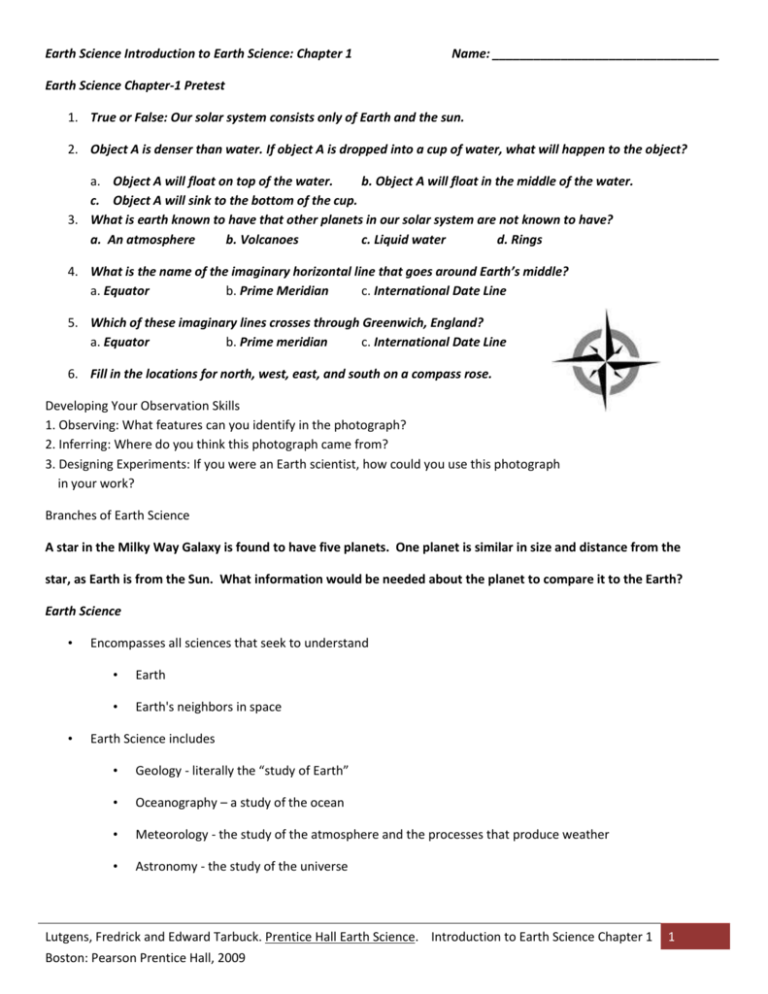
6. Fill in the locations for north, west, east, and south on a compass rose.
Developing Your Observation Skills
1. Observing: What features can you identify in the photograph?
2. Inferring: Where do you think this photograph came from?
3. Designing Experiments: If you were an Earth scientist, how could you use this photograph
in your work?
Branches of Earth Science
A star in the Milky Way Galaxy is found to have five planets. One planet is similar in size and distance from the
star, as Earth is from the Sun. What information would be needed about the planet to compare it to the Earth?
Earth Science
•
•
Encompasses all sciences that seek to understand
•
Earth
•
Earth's neighbors in space
Earth Science includes
•
Geology - literally the “study of Earth”
•
Oceanography – a study of the ocean
•
Meteorology - the study of the atmosphere and the processes that produce weather
•
Astronomy - the study of the universe
Lutgens, Fredrick and Edward Tarbuck. Prentice Hall Earth Science. Introduction to Earth Science Chapter 1
Boston: Pearson Prentice Hall, 2009
1
Earth Science
Geology is the science that pursues an understanding of planet Earth
Physical geology – examines the materials composing Earth and seeks to understand the many processes that operate
beneath and upon its surface
Historical geology – seeks an understanding of the origin of Earth and its development through time
Earth Science: Some historical notes about geology
•
The nature of Earth has been a focus of study for centuries
Catastrophism
Uniformitarianism and the birth of modern geology
Early evolution of Earth
•
Origin of Earth
•
Most researchers believe that Earth and the other planets formed at essentially the same time
•
Nebular hypothesis
The Nebular hypothesis
Solar system evolved from an enormous rotating cloud called the solar nebula
Nebula was composed mostly of hydrogen and helium
About 5 billion years ago the nebula began to contract
Assumes a flat, disk shape with the protosun (pre-Sun) at the center
Inner planets begin to form from metallic and rocky clumps
Larger outer planets began forming from fragments with a high percentage of ices
Early evolution of Earth
•
Formation of Earth’s layered structure
•
As Earth formed, the decay of radioactive elements and heat from high-velocity impacts caused the
temperature to increase
o
o
•
Iron and nickel began to melt and sink toward the center
Lighter rocky components floated outward, toward the surface
Gaseous material escaped from Earth’s interior to produce the primitive atmosphere
Earth’s Place in the Universe
Lutgens, Fredrick and Edward Tarbuck. Prentice Hall Earth Science. Introduction to Earth Science Chapter 1
Boston: Pearson Prentice Hall, 2009
2
Scales of Space and Time in Earth Science
Earth science involves investigations of phenomena that range in size from atoms to galaxies and beyond.
Chapter 1 Section 2: A View of Earth
Earth's “Spheres": (True or False)
_____ The atmosphere contains all of the water on Earth.
_____ Groundwater is part of Earth’s hydrosphere.
_____ Earth’s atmosphere does nothing to protect us from the sun’s radiation.
_____ There is no crust under Earth’s oceans.
_____ Earth’s crust is the same thickness under land as under water.
_____ The only layer of Earth that is solid is the crust.
_____ The biosphere affects all other spheres of Earth.
Earth's “Spheres"
•
Hydrosphere
•
Ocean – the most prominent feature of the hydrosphere
Nearly 71% of Earth's surface
•
•
•
•
About 97% of Earth's water
Also includes fresh water found in streams, lakes, and glaciers, as well as that found underground
Atmosphere
•
Thin, tenuous blanket of air
•
One half lies below 5.6 kilometers (3.5 miles)
Biosphere
•
Includes all life
•
Concentrated near the surface in a zone that extends from the ocean floor upward for several
kilometers into the atmosphere
Geosphere
•
Based on compositional differences, it consists of the crust, mantle, and core
•
Divisions of the outer portion are based on how materials behave
o
o
Lithosphere - rigid outer layer
Divisions of Earth’s surface - continents and ocean basins
Lutgens, Fredrick and Edward Tarbuck. Prentice Hall Earth Science. Introduction to Earth Science Chapter 1
Boston: Pearson Prentice Hall, 2009
3
Earth’s layered structure
Plate Tectonics
•
Plate tectonics is the theory that proposes that Earth’s outer shell consists of individual plates that interact in
various ways and thereby produce earthquakes, volcanoes, mountains, and Earth’s crust itself.
Destructive forces such as weathering and erosion work to wear away high points and flatten out the
surface.
Constructive forces such as mountain building and volcanism build up the surface by raising the land and
depositing new material in the form of lava.
o Depend on Earth’s internal heat for their source of energy.
Chapter 1 Section 3: Representing Earth’s Surface
Determining Location
Latitude and longitude are lines on the globe that are used to determine location.
-
Latitude is distance north or south of the equator, measured in degrees.
o Also known as parallels.
o Ranges from 0 - 90 Degrees
o 1 degree of latitude is approximately equal to 111 km (69 miles).
-
Longitude is distance east or west of the prime meridian, measured in degrees.
o Also known as meridians.
o Ranges from 0 - 180 Degrees
o 1 degree of longitude ranges from 111 km (69 miles) at the Equator to 0 km at the poles.
Meridians converge at the poles.
Representing Earth’s Surface
Latitude-Longitude Coordinates
1. Latitude always comes first.
2. A compass direction must be used for both latitude and longitude.
-
latitude can only be north or south of the equator
longitude can only be east or west of the prime meridian
3. Smaller units of a degree
- 1 minute of latitude = 1.85 km (1.16 miles)
- 1 second of latitude = .031 km (96 feet)
Example:
Coordinates for Delaware Valley High School in degrees, minutes, and seconds.
41o20’59” N, 74o44’15” W
Lutgens, Fredrick and Edward Tarbuck. Prentice Hall Earth Science. Introduction to Earth Science Chapter 1
Boston: Pearson Prentice Hall, 2009
4
Latitude-Longitude Coordinates
1. 20o South, 20o East
F H
1. 20o South, 100o East A F
3. 20o North, 40o East
F H
4. 60o South, 40o West
D J
5. 10o South, 40o West
C J
6. 0o, 140o West
B C
7. 40o North, 100o West E G
Maps and Mapping
•
No matter what kind of map is made, some portion of the surface will always look either too small, too big, or
out of place. Mapmakers have, however, found ways to limit the distortion of shape, size, distance and
direction.
•
The smaller the area mapped, the less distorted the map will be.
Mercator Projection
- Created by Gerardus Mercator in 1569
- Lines of latitude and longitude are parallel
- Shows direction accurately, but sizes and distances are distorted
(especially near poles)
- Used for seagoing navigators
Gnomonic Projection (Polar)
Made by placing a piece of paper on the globe so that it touches a single point
Useful to sailors and navigators because they show the shortest distance between two points
Lutgens, Fredrick and Edward Tarbuck. Prentice Hall Earth Science. Introduction to Earth Science Chapter 1
Boston: Pearson Prentice Hall, 2009
5
Conic Projection (Polyconic)
- Made by wrapping a cone of paper around a globe at a
particular line of latitude
- Almost no distortion along the line in contact
- Great accuracy over a small area, so these are used to make
topographic, road, and weather maps
Robinson Projection
Show most distances, sizes, and shapes accurately
Distortions near the edges of the map
Topographic Maps
Topographic maps represent Earth’s surface in three dimensions; they show elevation, distance directions, and slope
angles.
Contour lines are lines on a topographic map that indicate an elevation.
Contour interval is the distance in elevation between adjacent contour lines.
Small contour intervals are used for flat areas.
Larger contour intervals are used for mountainous terrain.
Shown at the bottom center of a topographic map.
Index Contours are heavier, darker contour lines that are labeled with the elevation. They are generally
every fifth contour line.
Depression Contours indicate a depression in the land, such as a crater.
Hachure marks are small lines, on a depression contour line, that point to the center of the
depression.
The elevation on the lip, or edge of the depression, is equal to the elevation of the regular
contour line beneath the depression.
Lutgens, Fredrick and Edward Tarbuck. Prentice Hall Earth Science. Introduction to Earth Science Chapter 1
Boston: Pearson Prentice Hall, 2009
6
Topographic Maps Elevation Indicators
Bench Marks are points of known elevation and position where a brass plate is physically found in the
ground. Shown on a map by the letters BM and the elevation given to the nearest foot.
Spot elevations are points of known elevation without a brass plate in the ground. Shown on a map
with an X.
Features Shown on a Topographic Map
Relief features–hills, valleys, mountains, plains, and other landforms
Water features–lakes, ponds, rivers, canals, swamps
Cultural features -- roads, railroads, and buildings
Topographic Map Colors
•
Black–manmade or cultural features, such as roads, buildings, names, and boundaries.
•
Blue–water features such as lakes, rivers, canals, glaciers, or swamps.
•
Brown–land shape portrayed by contour lines (relief).
•
Green–used for woodland cover with patterns to show scrub, vineyards, or orchards.
•
Red–important roads and public land subdivision lines
•
Red Tint–indicates urban areas in which only landmark buildings are shown.
•
Purple–show office revisions from aerial photographs which are not field checked.
Rules of Topographic Maps
-
All points along a contour line have the same elevation.
Contour lines form closed loops.
Circles represent hills or mountains.
Ovals represent ridges.
Contour lines never cross.
Contour lines never touch or intersect, except where there is a vertical cliff.
Contour lines that are close together indicate a steeper slope.
Contour lines that are farther apart indicate a gentle slope.
Contour lines “V” upstream.
Lutgens, Fredrick and Edward Tarbuck. Prentice Hall Earth Science. Introduction to Earth Science Chapter 1
Boston: Pearson Prentice Hall, 2009
7
Topographic Profiles
A cross section, or side view of the Earth’s surface along a given line
(baseline).
Determining a Gradient or Slope on a Topographic Map
Gradient (average slope) is the rate of change in elevation between two points on a topo. map.
Avg. Slope = Diff. in elevation of point A and B (ft)
Distance between A and B (mile)
Magnetic Declination
The acute angle between the directions of magnetic north and geographic north.
This angle is indicated at the bottom of a topo map.
Geographic North Pole (True North) is the location on Earth where the meridians or
lines of longitude converge.
Magnetic North Pole is the uncorrected direction indicated by the north seeking end of the
needle of a magnetic compass. Located in Canada.
Representing Earth’s Surface
Map scale is the ratio of distance on the map to distance on Earth.
Types of Scales:
1. Verbal or written scale– simple statement
•
Example: 1cm=1km
2. Graphic scale– a line divided into equal segments. Each segment length represents an actual distance
on land. The lines are marked in km, miles or other units of length.
3. Ratio or numerical scale– written using a representative fraction or ratio.
•
Example: 1:25,000 means that one unit on the map equals 25,000 of the same units on Earth’s
surface.
The more closely the map approaches the land in size, the larger the scale is.
Geologic Maps
•
A geologic map shows the type and age of exposed rocks.
Lutgens, Fredrick and Edward Tarbuck. Prentice Hall Earth Science. Introduction to Earth Science Chapter 1
Boston: Pearson Prentice Hall, 2009
8
Advanced Technology
•
Today’s technology provides us with the ability to more precisely analyze Earth’s physical properties.
•
The process of collecting data about Earth from a distance, such as from orbiting satellites, is called
remote sensing.
•
Satellites and computers provide more accurate maps.
•
Example: Global Positioning Systems (GPS)
Chapter 1 Section 4: Earth system science
•
Earth is a dynamic body with many separate but highly interacting parts or spheres
•
Earth system science studies Earth as a system composed of numerous parts, or subsystems
•
System - any size group of interacting parts that form a complex whole
•
Closed systems are self-contained (e.g. an automobile cooling system)
•
Open systems - both energy and matter flow into and out of the system (e.g. a river system)
Most natural systems are open systems.
•
•
Feedback mechanisms
•
Negative-feedback mechanisms resist change and stabilize the system
•
Positive-feedback mechanisms enhance the system
Earth as a system
•
Consists of a nearly endless array of subsystems
(e.g. hydrologic cycle, rock cycle)
Earth as a system
•
Sources of energy
•
Sun – drives external processes such as weather, ocean circulation and erosional processes
Earth’s interior – drives internal processes including volcanoes, earthquakes and mountain
building
Humans are part of the Earth system
Our actions produce changes in all of the other parts of the Earth system.
People and the environment
•
Environment
•
Surrounds and influences organisms
Lutgens, Fredrick and Edward Tarbuck. Prentice Hall Earth Science. Introduction to Earth Science Chapter 1
Boston: Pearson Prentice Hall, 2009
9
•
•
Physical environment encompasses water, air, soil, and rock
•
Term “environmental” is usually reserved for those aspects that focus on the relationships between
people and the natural environment
Resources
•
An important focus of the Earth sciences
•
Includes water, soil, minerals, and energy
•
Two broad categories
Renewable – can be replenished (examples include plants and energy from water and wind)
Nonrenewable – metals (examples include metals and fuels)
•
•
•
The processes that create them are so slow that it takes millions of years for significant
deposits to accumulate.
Population
•
Population of the planet is growing rapidly
•
Rate of mineral and energy usage has climbed more
rapidly than the overall growth of population
Environmental problems
•
Local, regional, and global
•
Human-induced and accentuated : Urban air pollution, Acid rain, Ozone depletion, Global warming
•
Natural hazards: Earthquakes, Landslides, Floods, Hurricanes
•
World population pressures
Chapter 1 Section 5: Scientific inquiry
•
•
Science assumes the natural world is
•
Consistent
•
Predictable
Goal of science
•
To discover patterns in nature
•
To use the knowledge to predict
Lutgens, Fredrick and Edward Tarbuck. Prentice Hall Earth Science. Introduction to Earth Science Chapter 1
Boston: Pearson Prentice Hall, 2009
10
•
•
•
An idea can become a
•
Hypothesis (tentative or untested explanation)
•
Theory (tested and confirmed hypothesis)
•
Paradigm (a theory that explains a large number of interrelated aspects of the natural world)
Scientific method
•
Gather facts through observation
•
Formulate hypotheses and theories
Scientific knowledge is gained through
•
Following systematic steps
Collecting facts
Developing a hypothesis
Conduct experiments
Re-examine the hypothesis and accept, modify, or reject
•
Theories that withstand examination
•
Totally unexpected occurrences
End of Chapter 1
Lutgens, Fredrick and Edward Tarbuck. Prentice Hall Earth Science. Introduction to Earth Science Chapter 1
Boston: Pearson Prentice Hall, 2009
11
Name: ___________________________________ Pd: _____ Date: __________________ Magic Number: ___
Magic Squares
Directions: Select the best answer for each of the following terms from the number definitions. Put the
number in the proper space in the magic square box. If the totals of the numbers are the same across,
up-and-down and diagonal, you have found the magic number!
theory ____
geology
____
hydrosphere
____
biosphere
____
longitude
____
atmosphere
____
topographic
map
____
system ____
hypothesis
____
contour
interval
____
geosphere
____
contour lines
____
latitude ____
astronomy
meteorology
Earth science
____
____
____
1. The name of the group of sciences that deal with Earth and its neighbors in space is called?
2. All the water on Earth makes up this
3. A word that means “study of Earth”.
4. A distance measured in degrees north or south of the equator
5. A distance measured in degrees east or west of the prime meridian is
6. This tells you the difference in elevation between two adjacent lines on a topographic map.
7. Lying beneath both the atmosphere and the ocean is the
8. This can be any size group of interacting parts that form a complex whole.
9. An untested scientific explanation is called
10. The gaseous envelope surrounding Earth is called the
11. This is used to represent the Earth’s three-dimensional surface in two dimensions.
12. The elevation on a topographic map is shown using this
13. This includes all life on Earth.
14. The study of the atmosphere and the processes that produce weather and climate is .
15. The branch of Earth science studies the universe
Lutgens, Fredrick and Edward Tarbuck. Prentice Hall Earth Science. Introduction to Earth Science Chapter 1
Boston: Pearson Prentice Hall, 2009
12
16. A scientific idea that is well tested and widely accepted by the scientific community is called a
Lutgens, Fredrick and Edward Tarbuck. Prentice Hall Earth Science. Introduction to Earth Science Chapter 1
Boston: Pearson Prentice Hall, 2009
13


