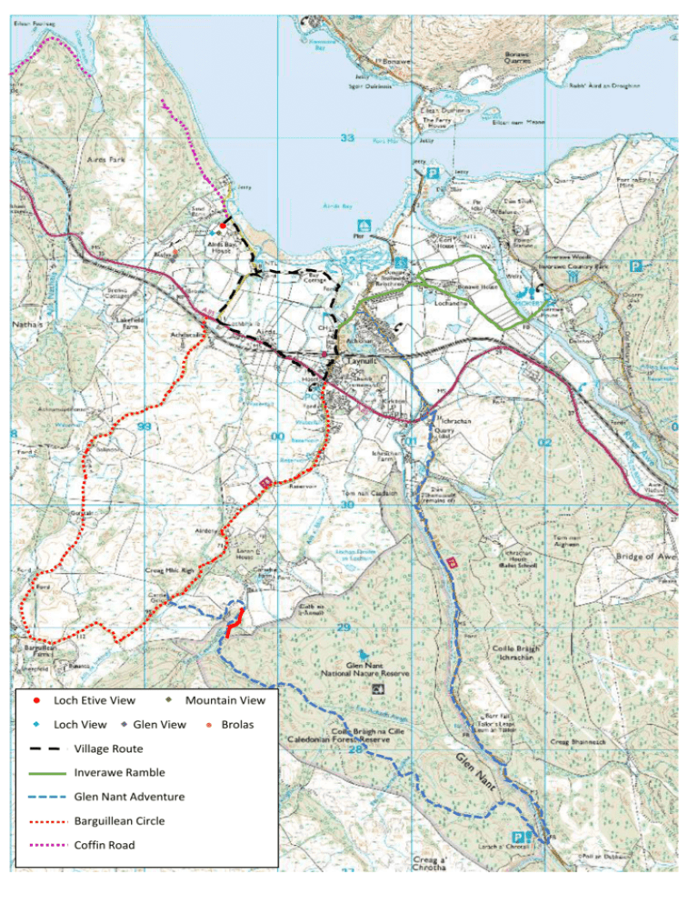
Local Walks/Mountain Bike Routes
advertisement

Loch Etive View Loch View Mountain View Glen View Village Route Inverawe Ramble Glen Nant Adventure Barguillean Circle Coffin Road Brolas Local Walks/Mountain Bike Routes These are some of the local routes that I do myself, either walking or biking, with or without the kids. The routes all join on to one another so I’ve not drawn them exactly back to the house, as long as you hit the red Village Route again you can walk or bike back. Please bear in mind that there may be livestock on route so take a lead for your dogs. Village Route approximately 2.5 miles I’ve shown the circular route up to the village. But if you prefer to avoid the main road, just walk back through the Golf Course. It is just over a mile to the Pub along the main road. You can do it all in walking boots and should be ok in trainers in the summer. You can change it a bit and walk part of it along the beach if the tides are right. Robins Nest Tea Room and Pub in the village Inverawe Ramble approximately 5 miles There is a nice gift shop and Tea Room at Inverawe Smokehouse. There is a nice walk round the Inverawe Country Park and a kid’s play area at the end of this route and it also connect onto the road down to the shore past the power station or into the forest trails or the track down Loch Etive. You need walking shoes or boots and you can Mountain bike it as well, although when you reach Inverawe you have to lift your bikes over the fence or just leave them and go to the Tea Room. The route crosses over the River Awe by a swing bridge, built by the Army. This is a couple of feet wide, wooden slatted and has steel netting up each side. You can walk over it easily, or push a bike. You can also stop off on the way and visit the Iron Furnace or take a detour down to the two village piers. Glen Nant Adventure!! – 10 miles I only ever mountain bike this but I see no reason why you can’t walk it. I’ve taken my son on it when he was 10 and he coped very well. You have to cycle some of it along roads, but they are only B roads. You leave the village on the Kilchrenan Road and carry on until you get to the Nant Forest Carpark and then follow the forestry track right back along to Corachie, then onto Cycle Route 78 and back to the village, you can off course take a different route back and follow the Barguillean Circle. There is a bit of a leap of faith when you get to the red section on this route. You are nearly home so it is worth continuing, this small section that you have to push the bike over is only 125 yards. The forest route comes to an end in a turning circle. Go to the edge of the circle opposite to where the road enters the circle. You then have to make your way down to a burn (small stream). Follow the burn along and on the opposite side you will see a wooden gate, just open it and there is a track to follow. Go along the track until you come to a stone covered track, bear left and follow this back to the road. Bear in mind if there has been a lot of rain the burn will be deeper and you will get wet feet. Barguillean Circle – 6 miles Lovely cycle or walk, walking shoes recommended, but trainers in the summer on a dry day would be fine. Do this walk in either directions the views are fantastic. There is an old Heather Nursery/Garden Centre at the junction between the Cycle Route 78. At this point you can continue up Route 78 and reach Angus’s Garden (about another 500 yards up the road). This is a fantastic garden to wander around, there is a small loch and routes round it. It is especially nice in the spring as there are lots of Rhododendrons and Azaleas planted. Also you can connect into the back of Fernoch Forest from the gardens, there are lots of cycle routes round it. Coffin Road Not one to cycle, walking boots/shoes ok in very dry weather but wellies might be better!! This is the route that they took coffins back to Oban a long time ago. It is quite overgrown in places, rough underfoot but a really nice walk. The route has vanished in one place so you will have to follow the map to connect up to the next bit, but even if you only do the first bit it a nice walk. You walk down our drive, turn left and walk along the road, you have to cut up left across some rough ground until you find the gate in the fence, if you get as far as the pier you gone too far along the road. If you look at the map the gate is on the fence line which runs up from the first of the two houses at the end of the road. The gate is locked so you have to climb it, there is a bit of gap underneath for dogs to squeeze through, my old Labrador could do it. Hope you manage to do some of the routes. If you have any problems on them finding the way or just really enjoy them please let me know.


