L7 \\\- Group Rubric
advertisement
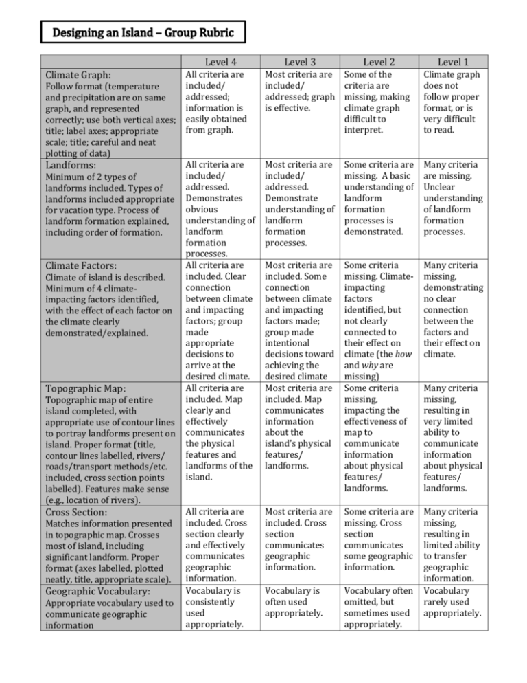
Level 4 Level 3 Level 2 Level 1 Climate Graph: All criteria are included/ addressed; information is easily obtained from graph. Most criteria are included/ addressed; graph is effective. Some of the criteria are missing, making climate graph difficult to interpret. Climate graph does not follow proper format, or is very difficult to read. Landforms: All criteria are included/ addressed. Demonstrates obvious understanding of landform formation processes. All criteria are included. Clear connection between climate and impacting factors; group made appropriate decisions to arrive at the desired climate. All criteria are included. Map clearly and effectively communicates the physical features and landforms of the island. Most criteria are included/ addressed. Demonstrate understanding of landform formation processes. Some criteria are missing. A basic understanding of landform formation processes is demonstrated. Many criteria are missing. Unclear understanding of landform formation processes. Most criteria are included. Some connection between climate and impacting factors made; group made intentional decisions toward achieving the desired climate Most criteria are included. Map communicates information about the island’s physical features/ landforms. Some criteria missing. Climateimpacting factors identified, but not clearly connected to their effect on climate (the how and why are missing) Some criteria missing, impacting the effectiveness of map to communicate information about physical features/ landforms. Many criteria missing, demonstrating no clear connection between the factors and their effect on climate. All criteria are included. Cross section clearly and effectively communicates geographic information. Vocabulary is consistently used appropriately. Most criteria are included. Cross section communicates geographic information. Some criteria are missing. Cross section communicates some geographic information. Vocabulary is often used appropriately. Vocabulary often omitted, but sometimes used appropriately. Many criteria missing, resulting in limited ability to transfer geographic information. Vocabulary rarely used appropriately. Follow format (temperature and precipitation are on same graph, and represented correctly; use both vertical axes; title; label axes; appropriate scale; title; careful and neat plotting of data) Minimum of 2 types of landforms included. Types of landforms included appropriate for vacation type. Process of landform formation explained, including order of formation. Climate Factors: Climate of island is described. Minimum of 4 climateimpacting factors identified, with the effect of each factor on the climate clearly demonstrated/explained. Topographic Map: Topographic map of entire island completed, with appropriate use of contour lines to portray landforms present on island. Proper format (title, contour lines labelled, rivers/ roads/transport methods/etc. included, cross section points labelled). Features make sense (e.g., location of rivers). Cross Section: Matches information presented in topographic map. Crosses most of island, including significant landform. Proper format (axes labelled, plotted neatly, title, appropriate scale). Geographic Vocabulary: Appropriate vocabulary used to communicate geographic information Many criteria missing, resulting in very limited ability to communicate information about physical features/ landforms.

