Week 1 August 24
advertisement
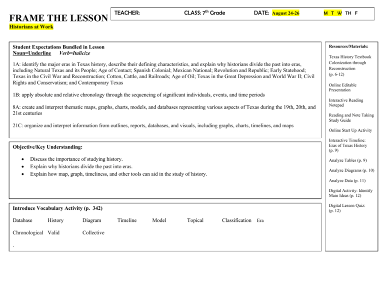
FRAME THE LESSON CLASS: 7th Grade TEACHER: DATE: August 24-26 M T W TH F Historians at Work Resources/Materials: Student Expectations Bundled in Lesson Noun=Underline Verb=Italicize 1A: identify the major eras in Texas history, describe their defining characteristics, and explain why historians divide the past into eras, including Natural Texas and its People; Age of Contact; Spanish Colonial; Mexican National; Revolution and Republic; Early Statehood; Texas in the Civil War and Reconstruction; Cotton, Cattle, and Railroads; Age of Oil; Texas in the Great Depression and World War II; Civil Rights and Conservatism; and Contemporary Texas Texas History Textbook Colonization through Reconstruction (p. 6-12) Online Editable Presentation 1B: apply absolute and relative chronology through the sequencing of significant individuals, events, and time periods 8A: create and interpret thematic maps, graphs, charts, models, and databases representing various aspects of Texas during the 19th, 20th, and 21st centuries Interactive Reading Notepad Reading and Note Taking Study Guide 21C: organize and interpret information from outlines, reports, databases, and visuals, including graphs, charts, timelines, and maps Online Start Up Activity Interactive Timeline: Eras of Texas History (p. 9) Objective/Key Understanding: Discuss the importance of studying history. Explain why historians divide the past into eras. Explain how map, graph, timeliness, and other tools can aid in the study of history. Analyze Tables (p. 9) Analyze Diagrams (p. 10) Analyze Data (p. 11) Digital Activity: Identify Main Ideas (p. 12) Digital Lesson Quiz: (p. 12) Introduce Vocabulary Activity (p. 342) Database History Chronological Valid . Diagram Collective Timeline Model Topical Classification Era Rigor & Relevance: (Real World Connection) Informal Assessment Questions 1-5 (p. 12) How is the historical knowledge different than personal knowledge? Why is it important to study different historical accounts of past events? Give an example of fa situation in which a historian should use a chronological organization of events instead of a topical organization. Suppose you want to compare the annual precipitation of Houston, Austin, and El Paso. Explain which type of graph is the best to use to view this data. Explain a solution in which a historian might use a database and graph together to analyze census data about the U.S. population. Critical Writing Prompt: Stop & Check for Understanding—High Level Questions Why is it important to understand how the past shaped the present? What is the difference between topical and chronological forms of information? What is the main difference between a timeline and a database? Small Group Purposeful Talk Question Stems Why Study History (p. 7-9) If a historian were to find your possessions hundreds of years from now, what might that historian learn about this time period? How would they do so? How might people who have different opinions about events tell the story to those events differently? What makes one interpretation of history more valid than the other? Why is studying history important? Dividing History into Eras (p. 9-10) Which is the main type of organization, topical or chronological? Why do you think historians divide the past into eras? Use the table on page 9 to answer the following: o Why might a historian have divided Texas history into these eras? o What are the likely defining characteristics of the Civil War and reconstruction Era? Presenting Information (p. 10-12) Which tool is most effective in presenting the information found on the Infographic “Visually Presenting Data: Texas Population” on page 11? After choosing two of the tools presented in the text, students are to respond to the following: o How can these tools help you better understand history? How would a diagram of the Alamo aid your understanding of text that tells about the events that occurred at the Alamo? What does the diagram offer that a text description does not? Online Resources, Analyzing Maps and Charts & Digital Activity Online Editable Presentation (p.6) Use the Editable Online Presentation found on the Digital Course to present the main ideas for this lesson. Interactive Reading Notepad Students can preview key terms and academic vocabulary using the Interactive Reading Notepad on the Digital Course or preview a summary of the lesson in the Reading and Note Taking Guide. Online Start Up Activity Teachers may also project the Start Up Activity from the course Interactive Timeline: Eras of Texas History (p. 9) Project the Interactive Timeline: Eras of Texas History (p. 9). Click on each of the 12 eras of Texas history and call on students to read the descriptions. Review the terms topical and chronological. Ask which is the main type of organization used in this graphic? Point out that the eras on the timeline are focused on a major event or development and all the things that happened around the same time as that event. Why do you think historians divide the past into eras? Analyze Tables (p. 9) Review the table on page 9. What are some important topics of themes that historians use to divide Texas’s history into eras? Analyze Diagrams (p. 10) Review the diagram on page 10. What information does viewing this diagram rather than reading a text about World War II help you understand? Analyze Data (p. 11) Review the table on page 11. How does viewing the same set of data in different ways help you interpret it differently? Are some presentations more effective than others? Why or why not? Digital Activity: Identify Main Ideas (p. 12) Project Digital Activity: Identify Main Ideas (p. 12). Tell students to review the questions for historians that they wrote during the Start Up Activity. Have students exchange questions with a partner and answer their partner’s questions. Review what students have learned about history and the role of historians. Students will answer the following: If you had the task of preparing a documentary about the first Texans, how would you gather information? What tools would you use to compile and present information clearly? How would you organize your information? Digital Lesson Quiz: (p. 12) Assign the Digital Lesson Quiz. Pose these questions: In Historians at Work, you learned that history is the study of past human events. You also learned how and why historians divide the past into eras. Finally, you were introduced to the tools historians use to organize and present historical information, including charts, graphs, diagrams, and timelines. Why would a historian choose to present information visually instead of describe it in words? What is an era? Why do historians divide history into eras? Engage ~Have students preview the lesson objectives and the list of key terms (p. 6). Use the Editable Presentation found on the digital course to present the main ideas of the lesson (p. 6). Complete the Start Up Activity on p 6. Ask students to think about what historians do and how they work. How do you think historians prepared the content you are using? How do you think they decided how to organize the content? How do you think they verified, or checked the accuracy of, their content? Tell students that this lesson examines the ways in which historians conduct their work, including how they research and present information. ~Divide the class into groups. Each group is to read a section and be prepared to discuss and share findings with the class. Explore Why Study History (p. 7-9) Dividing History into Eras (p. 9-10) Presenting Information (p. 10-12) Explain Elaborate Evaluate Students are to read assigned sections and use the Note Taking Study Guide to help them take notes and understand the text as they read. Tell students that this lesson examines the ways in which historians conduct their work, including how they research and present information. Why Study History (p. 7-9) While it is true that there is much to know in the here and now, understanding what is happening today requires knowing how we got here. Imagine that you did not know anything at all about your own past. Imagine that you woke up this morning knowing only your own name, your address, and how to get to school, but nothing else. Dividing History into Eras (p. 9-10) The past is a long time-a very long time, if we think about history as a big mass of events that took place before today, we will be overwhelmed. There is simply too much to study for it to make sense without some kind of classification. Classification involves arranging things into groups based on ways they are alike. That is why historians typically divide history into different eras. An era is a period of time that is associated with a particular person, event, or quality. Life does not always divide neatly into eras, but historians use these eras to help make history easier to understand. Presenting Information (p. 10-12) Historians use a variety of tools to present information about eras, places, people, events, and trends. ~Guided Reading and Discussion Questions See Small Group Purposeful Talk Question Stems from the previous page for this portion of the lesson. ~Analyzing Maps and Charts & Digital Activity See Online Resources from the previous page for this portion of the lesson. ~Assign the Digital Lesson Quiz for this lesson (p. 12). Teachers can also opt to have students demonstrate mastery by responding to the following questions on paper: How is the historical knowledge different than personal knowledge? Why is it important to study different historical accounts of past events? Give an example of fa situation in which a historian should use a chronological organization of events instead of a topical organization. Suppose you want to compare the annual precipitation of Houston, Austin, and El Paso. Explain which type of graph is the best to use to view this data. Explain a solution in which a historian might use a database and graph together to analyze census data about the U.S. population. TEACHER: CLASS: 7th Grade DATE: August 27-28 M T W TH F FRAME THE LESSON Texas Geography Resources/Materials: Student Expectations Bundled in Lesson Noun=Underline Verb=Italicize 19A: locate the Mountains and Basins, Great Plains, North Central Plains, and Coastal Plains regions and places of importance in Texas during the 19th, 20th, and 21st centuries such as major cities, rivers, natural and historic landmarks, political and cultural regions, and local points of interest 9B: compare places and regions of Texas in terms of physical and human characteristics 21C: organize and interpret information from outlines, reports, databases, and visuals, including graphs, charts, timelines, and maps U.S. History Textbook Colonization through Reconstruction pp. (13-31) Online Editable presentation (p. 13) Start Up Activity: Analyze Maps (p. 13) Reading and Note Taking Study Guide (p. 13) Interactive Map: Exploring Texas Using Maps (p. 14, 15, 24, 25, 27,28, 29) Interactive Reading Notebook (p. 15) Analyze Diagrams (p. 17) Analyze Maps (p. 18, 22, 23, 25, 27, 28, 29) Objective/Key Understanding: Identify how geography helps people understand and organize information about a place. Compare the physical and human characteristics of Texas and the lands around it. Digital Activity: Describe (p. 31) Digital Lesson Quiz: (p. 31) Introduce Vocabulary Activity (p. 13) Landform Latitude Relief plate tectonics longitude scale climate equator physical map Rigor & Relevance: (Real World Connection) vegetation meridian political map culture globe map physical geography prime meridian projection human geography absolute location drought Informal Assessment Questions 1-5 (p. 31) Why should a person who wants to know about plant and animal life study the climate in that region? Explain how physical and human geography interact in places such as the Rio Grande Valley. How does the geographic theme of movement help explain how cultures change and become more diverse? Describe a situation in Texas in which the boundaries of a physical region and an economic region could overlap. Explain the strategy a geographer could use to study a boundary dispute between Texas and Mexico. Stop & Check for Understanding—High Level Questions What does culture include? How would you define a region? Critical Writing Prompt: What is the purpose of a physical map? What factors influence the physical geography of Texas? What physical feature serves as the border between Texas and Mexico? What is a mesa? What physical characteristics make the Great Plains region a good place for gazing animals and farming? What physical characteristics define West Texas? Small Group Purposeful Talk Question Stems What is Geography? (p. 14-17) Which region of Texas has the most rainfall? How does the climate of southern Texas differ from that of the Panhandle? Where are mountains located in Texas? Thinking Like a Geographer (p. 17-21) Use the diagram, The Five Themes of Geography, on page 17 to answer the following: which of the five themes involves the relationship of humans to the environment? Using the map on page 18, what is the location of Texas within the Americas? Geographer’s Tools (p. 21-24) Using the picture on page 21, identify two more ways to view digital maps. Using the map on page 22, which area of Texas has the highest elevation? What general pattern in elevation can you identify from the map? Using the map on page 23, about how large is Texas in comparison to the complete United States? The Physical and Human Characteristics of Texas (p. 24-25) Using the map, The Location of Texas, on page 23, what is one physical characteristic of Texas shown on the map? How do regions of Texas compare in terms of physical characteristics? How do regions of Texas compare in terms of human characteristics? To what larger regions does Texas belong? Small Group Purposeful Talk Question Stems Continued The Coastal Plains (p. 25-27) Using the map, The Coastal Plains Region of Texas, on page 25, describe the relative location of the region. Identify and locate cities found in this region. What city is the farthest south? Which major river flows along the southern edge of the coastal plain and forms part of the border of Mexico? What other major rivers flow through this region and where are they located? What major natural landmark demarcates the western edge of this region? The North Central Plains (p. 27-28) Using the Coastal Plains Region of Texas Map on page 25 and the North Central Plains Region Map on page 27, how do the two plains regions differ? What type of major natural landmark do both regions have? Using the North Central Plains Region Map on page 27, what major natural landmark forms part of the western boundary of the North Central Plains Region? What major river forms its northern boundary? What major towns and cities are found in this region? What other major natural landmark lies along part of the western boundary of this region? The Great Plains (p. 28-29) What major natural landmarks divide this region from the other plains regions? In terms of physical characteristics, how does this region compare with the other two plains regions? What physical features most distinguish this region from the others? What major cities are located in this region? What major rivers flow through this region? What major historical landmarks are located in the Panhandle region? The Mountains and Basins (p. 29-31) Using the map The Mountains and Basins Region of Texas on page 29, how does the Mountains and Basins region compare with the other regions in terms of physical and human characteristics? Using the map The Mountains and Basins Region of Texas on page 29, what major natural landmarks are found in this region, and where are they located? Using the map The Mountains and Basins Region of Texas on page 29, what major historical landmarks are found in this region, and where are they located? Online Resources, Analyzing Maps and Charts & Digital Activity Start Up Activity: Analyze Maps (p. 13) Teachers may also project the Start Up Activity from the course Reading and Note Taking Study Guide (p. 13) Teachers may also project the Start Up Activity from the course Interactive Map: Exploring Texas Using Maps (p. 14) Based on the infographic, what generalizations can you make about the physical geography of the state of Texas? (p. 15) Name two features that are characteristic of the Texas climate. (p. 18) What is the location of Texas within the Americas? (p. 22) Which area of Texas has the highest elevation? What general pattern in elevation can you identify from the map? (p.23) About how large is Texas in comparison to the complete United States? (p.25) What is the relative location of the Coastal Plains region? (p.27) How does the North Central Plains region compare in size to the Coastal Plains region? (p.28) What states border the Great Plains region on the north and west? (p.29) How have the physical features of the Mountains and Basins region of Texas likely affected its settlement? Interactive Reading Notebook (p. 15) Students can preview key terms and academic vocabulary using the Interactive Reading Notepad on the Digital Course or preview a summary of the lesson in the Reading and Note Taking Guide. Analyze Diagrams (p. 17) Which of the five themes involves the relationship of humans to the environment? Digital Activity: Describe (p. 31) Project the Digital Activity: Describe (p. 31). Have students record their ideas about the maps. Then have students share their answers with partners or in groups. Draw a concept web and discuss what and how maps and other geographic tools have helped them learn about Texas. What historical information can you learn from maps? How can geographic information help you understand historical events? Digital Lesson Quiz: (p. 31) Assign the Digital Lesson Quiz (p. 31). Pose these questions to the class: In Texas Geography, you learned how physical and human characteristics affect a place and how geography can help people understand this effect. You also learned about Texas’s four major geographic regions: Coastal Plains, North Central Plains, Great Plains, and Mountains and Basins. Consider the landscape, waterways, and climate patterns of the different regions. How do you think these geographic factors impacted early human settlement in Texas? What about later European exploration and colonization? Based on what you have learned, on what resources do you think the first people to live in Texas depended? In what economic activities do you think the early peoples in different regions engaged? Engage ~Have students preview the lesson objectives and the list of key terms (p.13). Use the Editable Presentation found on the digital course to present the main ideas of the lesson (p. 13). Complete the Start Up Activity on p 13. Project the Start Up Activity: Analyze Maps. Ask students to study the map and write their responses. Draw students attention to features of the map, including the title bar, he scale, the compass, rose, and the subject and non-subject areas of the map. What are the four geographic regions of Texas? What information might you learn by using the scale? What information does the inset map of the United States give you? Explore Explain Elaborate Evaluate Tell students that in this lesson they will be examine the significance of Texas geography, compare places and regions of Texas in terms of their physical and human characteristics, and interpret information from visuals, including maps. ~Divide the class into groups. Each group is to read a section and be prepared to discuss and share findings with the class. What is Geography? (p. 14-17) Thinking Like a Geographer (p. 17-21) Geographer’s Tools (p. 21-24) The Physical and Human Characteristics of Texas (p. 24-25) The Coastal Plains (p. 2527) The North Central Plains (p. 27-28) The Mountains and Basins (p. 29-31) Students are to read assigned sections and use the Note Taking Study Guide to help them take notes and understand the text as they read. ~ Tell students that in this lesson they will be examine the significance of Texas geography, compare places and regions of Texas in terms of their physical and human characteristics, and interpret information from visuals, including maps. What is Geography? (p. 14-17) So, how do you answer the question? It takes a lot of thought and study, and it is an ongoing process. When answering such big questions, it helps to have a special way of looking at things. Geography is one special way of looking at and describing things. Thinking Like a Geographer (p. 17-21) Suppose that your school is creating a time capsule that will be opened one hundred years from now. Your teacher has asked you to describe yourself in writing to the students of the future. What will you say? Geographer’s Tools (p. 21-24) Geographers, like other professionals, use tools to investigate their subject. Think about other professions. You can probably picture the tools they use. Carpenters use familiar tools such as hammers and saws, wrenches, and screwdrivers to build things. Doctors use tools to find out about their patients’ health. After your doctor takes a measurement an conducts many tests, he or she would have a good overall picture of the state of your health. The Physical and Human Characteristics of Texas (p. 24-25) Texas is part of the United States, which makes up part of the continent of North America. Geographers divide North America into several natural regions. For example, the Coastal Plan of Texas is part of a large region that wraps along the Gulf and Atlantic coasts. The Coastal Plains (p. 25-27) The Coastal Plains region of Texas covers the eastern and southern part of the state. It is the largest region in Texas. It is also home to more Texans than any other region. The North Central Plains (p. 27-28) North and west of the Coastal Plains of Texas is the North Central Plains region. It is part of a region that begins in Canada and covers much of the central United States. The Mountains and Basins (p. 29-31) The Mountains and Basins region makes up the westernmost par t of Texas. This is a part of a larger region known as the Basin and Range Providence that extends from Mexico and covers much of New Mexico, Arizona, and Nevada. ~Guided Reading and Discussion Questions See Small Group Purposeful Talk Question Stems from the previous page for this portion of the lesson. ~Analyzing Maps and Charts & Digital Activity See Online Resources from the previous page for this portion of the lesson. ~Assign the Digital Lesson Quiz for this lesson (p. 31). Teachers can also opt to have students demonstrate mastery by responding to the following questions on paper: Why should a person who wants to know about plant and animal life study the climate in that region? Explain how physical and human geography interact in places such as the Rio Grande Valley. How does the geographic theme of movement help explain how cultures change and become more diverse? Describe a situation in Texas in which the boundaries of a physical region and an economic region could overlap. Explain the strategy a geographer could use to study a boundary dispute between Texas and Mexico.
