Africa - geographic information condensed
advertisement
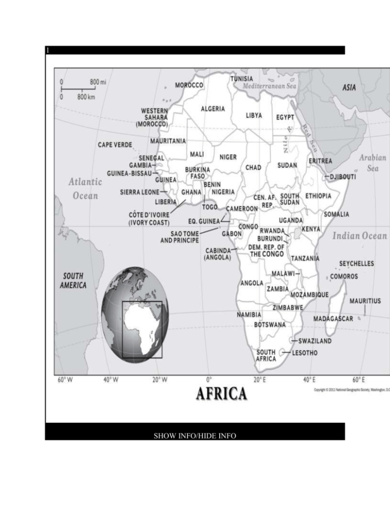
1 SHOW INFO/HIDE INFO Africa is sometimes nicknamed the "Mother Continent" due to its being the oldest inhabited continent on Earth. Humans and human ancestors have lived in Africa for more than 5 million years. Map by the National Geographic Society Africa is home to diverse ecosystems, from sandy deserts to lush rain forests. Map by the National Geographic Society Largest Urban Area Cairo, Egypt (10,900,000 people) Highest Elevation Mount Kilimanjaro, Tanzania (5,895 meters/19,341 feet) Largest Watershed Congo River (3,730,881 square kilometers/1,440,051 square miles) Population Density 34 people per square kilometer Amount of Renewable Electricity Produced 35% (top producer of renewable energy: Mozambique, 99.9%) Africa, the second-largest continent, is bounded by the Mediterranean Sea, the Red Sea, the Indian Ocean, and the Atlantic Ocean. It is divided in half almost equally by theEquator. Africas physical geography, environment and resources, andhuman geography can be considered separately. Africa has eight major physical regions: the Sahara, theSahel, the Ethiopian Highlands, the savanna, the Swahili Coast, the rain forest, the African Great Lakes, and Southern Africa. Some of these regions cover large bands of the continent, such as the Sahara and Sahel, while others are isolated areas, such as the Ethiopian Highlands and the Great Lakes. Each of these regions has unique animal and plant communities. Sahara The Sahara is the worlds largest hot desert, covering 8.5 million square kilometers (3.3 million square miles), about the size of the South American country of Brazil. Defining Africas northern bulge, the Sahara makes up 25 percent of the continent. The Sahara has a number of distinct physical features, including ergs, regs, hamadas, and oases. Ergs, which cover 20 percent of the Sahara, are sand dunes that stretch for hundreds of kilometers at heights of more than 300 meters (1,000 feet). Ergs cover most of Algeria and Libya and parts of Mali and Nigeria. Ergs can contain large quantities of salt, which is sold for industrial and food use. Regs are plains of sand and gravel that make up 70 percent of the Sahara. The gravel can be black, red, or white. Regs are the remains of prehistoric seabeds and riverbeds, but are now nearly waterless. Hamadas are elevated plateaus of rock and stone that reach heights of 3,353 meters (11,000 feet). They include the Atlas Mountains, which stretch from southwestern Morocco to northeastern Tunisia; the Tibesti Mountains of southern Libya and northern Chad; and the Ahaggar Mountains in southern Algeria. An oasis is a hub of water in the desert, often in the form ofsprings, wells, or irrigation systems. About 75 percent of the Saharas population lives in oases, which make up only 2,071 square kilometers (800 square miles) of the deserts vast area. The Saharas animal and plant communities have adapted to the regions extremely dry conditions. The kidneys of the jerboa, a type of rodent, produce highly concentrated urine that minimizes water loss. A dromedary camel conserves water by changing its body temperature so it doesnt sweat as the day gets hotter. The scorpion limits its activities to night, burrowing into the cooler sands beneath the surface during the day. The scorpion, a predator, also absorbs water from the flesh of its prey. Saharan plants survive thanks to root systems that plunge as far as 24 meters (80 feet) underground. In parts of the Sahara, plants cannot take root at all. In the southern Libyan Desert, for instance, no greenery exists for more than 195 kilometers (120 miles). Sahel The Sahel is a narrow band of semi-arid land that forms atransition zone between the Sahara to the north and the savannas to the south. It is made up of flat, barren plains that stretch roughly 5,400 kilometers (3,300 miles) across Africa, from Senegal to Sudan. The Sahel contains the fertile delta of the Niger, one of Africas longest rivers. Unfortunately, the Sahels fertile land is rapidly becoming desert as a result of drought, deforestation, and intensive agriculture. This process is known asdesertification. The Sahels animal communities are constantly scavenging for scarce water and vegetation resources. The Senegal gerbil, the most common mammal in the Sahel and measuring only a few centimeters, consumes as much as 10 percent of the Sahels plants. The Sahels green vegetation only emerges during the rainy season, but is often quickly harvested by farmers or consumed by animals. Baobabs are drought- and fire-resistant trees with trunks that are often 15 meters (50 feet) wide and as tall as 26 meters (85 feet). Acacia, whose deep root systems are ideal for semi-arid climates, are among the most common trees found in the Sahel. Cram-cram, a prickly grass, is the primary fodder for Sahel herds such as zebucattle. Ethiopian Highlands The Ethiopian Highlands began to rise 75 million years ago, as magma from Earths mantle uplifted a broad dome ofancient rock. This dome was later split as Africas continental crust pulled apart, creating the Great Rift Valley system. Today, this valley cuts through the Ethiopian Highlands from the southwest to the northeast. The Ethiopian Highlands are home to 80 percent of Africas tallest mountains. The highlands craggy landscape is perfect for nimble animal species. Native species such as the walia ibex, anendangered wild goat, and the gelada baboon live in the ledges and rocky outposts of the Simien Mountains. The most emblematic highlands species is probably the Ethiopian wolf, which is now on the brink of extinction. Important plant species native to the Ethiopian Highlands include the Ethiopian rose, Africas only native rose, and the ensete, a tall, thick, rubbery plant that is a close relative of the banana. Key Concepts 1. savannas 2. sahel 3. rain forests 4. physical geography 5. mountains 6. lakes 7. sahara 8. deserts 9. continents 10. africa

