GEO143_lab_3_key
advertisement
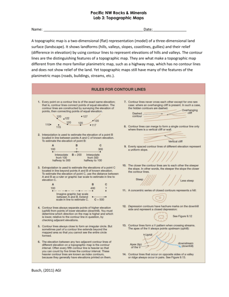
Pacific NW Rocks & Minerals Lab 3: Topographic Maps Name: ________________________________________________ Date: ________________ A topographic map is a two-dimensional (flat) representation (model) of a three-dimensional land surface (landscape). It shows landforms (hills, valleys, slopes, coastlines, gullies) and their relief (difference in elevation) by using contour lines to represent elevations of hills and valleys. The contour lines are the distinguishing features of a topographic map. They are what make a topographic map different from the more familiar planimetric map, such as a highway map, which has no contour lines and does not show relief of the land. Yet topographic maps still have many of the features of the planimetric maps (roads, buildings, streams, etc.). Busch, (2011) AGI Part 1: Understanding Topographic Maps (15 pts) 1. Label the elevation of the contours on the map below. Watch out for depressions with repeated contours! Contour Interval = 20 m 2. Use interpolation and extrapolation to estimate and label elevations of all points below that are not labeled (see Figure 9.10 for help). Then add contour lines using a contour interval of 100 meters. Notice how the 0-meter and 100meter contour lines have already been drawn. Sea level elevation = 0 m. Remember the rule of V's! Estimate the elevation of location X by interpolating between the contour lines. X = ____250_______ m Page | 5 3. Using the topographic map below, construct a topographic profile from A to A’. Grey shaded areas are rivers. Refer to the Rules for Contour Lines above. On the profile you just created a. What is the horizontal scale in meters/inch? 1,000___________ m/inch b. What is the vertical scale in meters/inch (round to the nearest 100)? 100____________ m/inch c. What is the vertical exaggeration? 10 : 1 Page | 6 Part 2: Topography of Mt. Saint Helens (15 pts) For this section, examine the topographic map of Mt. Saint Helens! All of the information in this section is written somewhere on the map so it should be relatively easy to find. Part A: Basic Topographic Map Features 1. What is the name of this quadrangle? Mt. St. Helens 2. What part of Washington State is this quadrangle in? Southwest Washington 3. Is this a 7 ½ or a 15 minute quadrangle? 7 ½ minute 4. What is the difference in area between a 7 ½ and a 15 minute quadrangle? A 7 ½ minute quadrangle spans 7 ½ minutes north and south. 7 ½ minutes is 1/8 of a degree. A 15 minute quadrangle spans 15 minutes north and south. 15½ minutes is 1/4 of a degree. 5. What is the ratio scale (or, relative fraction scale) of this map? 1 : 24,000 6. How many meters in real life does 1 cm on the map equal? 1 cm on the map (Map Distance) = 24,000_______ meters in real life (Real World Distance) 7. What is the magnetic declination in the area of this map? 20° East 8. If you wanted to hike eastward past the limit of this map, which quadrangle would you need a map of? Smith Creek Butte 9. Benchmarks are locations of known location and elevation. Benchmarks are shown on the topographic map by an x symbol followed by the elevation value. Calculate the total relief shown on the topographic map using the benchmarks. Total relief = 5,650______ ft 8,365 – 2,715 = 5,650 Page | 7 Part B: Using Topographic Maps for Measurement and Navigation Now that you understand the basics, try and find your way around the map. 10. What is the distance in meters between the northern and southern peaks at Butte Camp Dome? 4,856 – 4,747 = 109 m 109______ m 11. If you hiked east along the Muddy River, would you be traveling uphill or downhill? downhill 12. What is the horseshoe-shaped structure in the center of the map? The 1980 crater. 13. What is the small (about one inch) feature in the center of this horseshoe-shaped structure? The Lava Dome. 14. What feature is located at the northern opening of this horseshoe-shaped structure? What do you think caused this? The Breach. The Landslide and eruption of May 18, 1980. 15. Where is the majority of the vegetation located on this map? Why? The south side of the map. The eruption killed all the vegetation to the north. 16. If you wanted to hike to the lava dome to roast marshmallows, what would be the easiest direction to hike from? Why? The South because it is low relief and one would not need to traverse the higher elevations of the crater rim. 17. You are standing at the lava dome and want navigate to the following locations using your map and compass. What is the compass bearing from the lava dome to the following locations? a. Crescent Ridge? 270° b. Redrock Pass? 200° c. Forsyth Glacier? 40° 18. Look at the glaciers on the map. a. What feature is present at the base of most glaciers? Creek or River b. Why is this feature present? The glaciers melt Page | 8 19. Locate the Shoestring Glacier. a. What is the length of the glacier in km? ~2 km km b. What is the relief of the glacier in ft? 8,080 – 4,640 = 3,440 ft ft c. What is the relief of the glacier in meters (1 m = 3.28 ft)? 3,440 ft X 1m/3.28ft = 1,050 m m d. What is the gradient of the glacier in m/km? 1,050 m / 2 km m/km 20. Locate the Tallus Glacier. a. What is the length of the glacier in km? 0.8 km km b. What is the relief of the glacier in ft? 7,560 – 5,720 = 1,840 ft c. What is the relief of the glacier in meters (1 m = 3.28 ft)? 1,840 X 1m/3.28ft = 561 m m Page | 9


