The South of Java Earthquake and Tsunami of July 17, 2006: A
advertisement

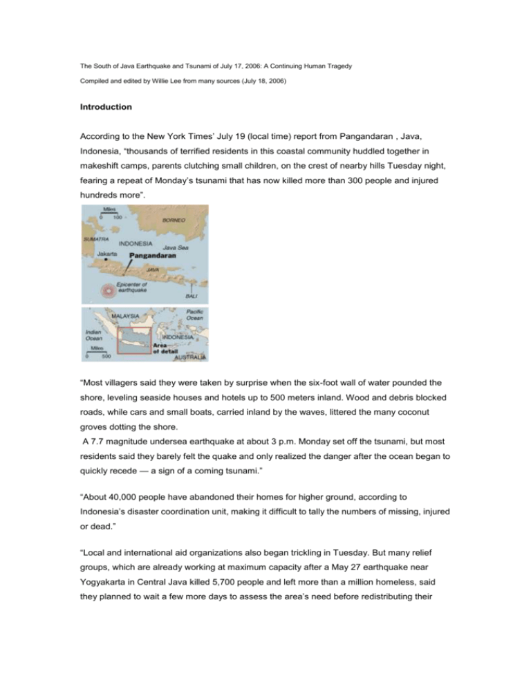
The South of Java Earthquake and Tsunami of July 17, 2006: A Continuing Human Tragedy Compiled and edited by Willie Lee from many sources (July 18, 2006) Introduction According to the New York Times’ July 19 (local time) report from Pangandaran , Java, Indonesia, “thousands of terrified residents in this coastal community huddled together in makeshift camps, parents clutching small children, on the crest of nearby hills Tuesday night, fearing a repeat of Monday’s tsunami that has now killed more than 300 people and injured hundreds more”. “Most villagers said they were taken by surprise when the six-foot wall of water pounded the shore, leveling seaside houses and hotels up to 500 meters inland. Wood and debris blocked roads, while cars and small boats, carried inland by the waves, littered the many coconut groves dotting the shore. A 7.7 magnitude undersea earthquake at about 3 p.m. Monday set off the tsunami, but most residents said they barely felt the quake and only realized the danger after the ocean began to quickly recede — a sign of a coming tsunami.” “About 40,000 people have abandoned their homes for higher ground, according to Indonesia’s disaster coordination unit, making it difficult to tally the numbers of missing, injured or dead.” “Local and international aid organizations also began trickling in Tuesday. But many relief groups, which are already working at maximum capacity after a May 27 earthquake near Yogyakarta in Central Java killed 5,700 people and left more than a million homeless, said they planned to wait a few more days to assess the area’s need before redistributing their resources from Yogyakarta or from Banda Aceh, where a much larger tsunami killed 170,000 people in 2004.” The July 17 South of Java Earthquake: USGS Summary The United States Geological Survey, National Earthquake Information Center announced that a major earthquake occurred 225 km northeast of Christmas Island or 355 km south of Jakarta, Java, Indonesia at 08:19:25 UTC Jul 17, 2006 (3:19 PM local time in Indonesia). The Harvard moment magnitude for this quake is 7.7. Many buildings destroyed by a tsunami with wave heights of at least two meters in the Pangandaran area. Felt as far as Jakarta. A tsunami with wave heights of 60 cm reported at Christmas Island. The earthquake occurred as a result of thrust-faulting on the boundary between the Australia plate and the Sunda plate. On this part of their mutual boundary, the Australia plate moves north-northeast with respect to the Sunda plate at about 59 mm/year. The Australia plate thrusts beneath the Sunda plate at the Java trench, south of Java, and is subducted to progressively greater depths beneath Java and north of Java. The earthquake occurred on the shallow part of the plate boundary, about 50 km north of the Java trench. The region of the plate boundary between the Australia plate and Sunda plate is seismically highly active. From preliminary results, it appears that today's earthquake is similar to the earthquake of June 2, 1994, magnitude 7.8, which produced a tsunami that had a maximum run-up height of 13 meters and killed over 200 people. That earthquake occurred south of Java about 600 km east-southeast of today's earthquake, also as a result of thrust faulting on the shallow plate boundary. On August 20, 1977, a magnitude 8.3 normal-fault earthquake occurred within the Australia plate about 1200 km east-southeast of today's earthquake, producing a tsunami that had a maximum run-up height of 15 meters and killed almost 200 people. This year's May 26 devastating Yogyakarta earthquake, magnitude 6.3, occurred at shallow depth within the overriding Sunda plate. A seismicity cross section is shown below: A Continuing Human Tragedy Although the local residents barely felt the earthquake (about 200 km away), the resulting tsunami waves arrived in about 30 minutes, leaving little time for the local residents living near the coast to react. After the great tragedy of the 2004 Sumatra earthquake and tsunami, the United Nations (with the financial help of many nations) began the implementation of the Indian Ocean Tsunami Warning System. According to the New Scientist magazine (06 July 2006, page 4), “around the Indian Ocean 26 countries now have a tsunami early-warning system. It makes use of 25 new seismographic stations linked in real time to analysis centers, and three deep-ocean sensors, which consist of a seafloor-pressure recording device linked to a surface buoy.” Koichiro Matsuura, the director-general of UNESCO, announced in Paris, France, on 29 June that the system “will be capable of improved and faster detection of strong, tsunamigenic earthquakes”. But he emphasized that there are two major challenges remaining. First, national systems must be able to coordinate with each other, with free exchange of data. Second, long-term investment is essential to ensure the information from the warning center to populations and communities at risk. However, Paul Burton of the University of East Anglia, UK, says that any warning issued must be reliable, relayable and that those who receive it must be able to act upon it. “The political will to educate and inform the people is a key issue. Will there be the means to relay information to those who live on and near the beaches? And will the system be working in 300 years, when we might need it?” Less than one month later, the South of Java earthquake occurred. It is a large earthquake, but not great (M>=8) or mega (M>=9). Whatever warning system now in place did nothing to help the local residents about 200 km away. My own comments about tsunami hazards are: (1) a large earthquake can generate a local tsunami that kills many people, (2) an ocean-wide tsunami warning system based on a limited number of high-tech seismic and DART stations at spacing of 1,000 km can not help much in detecting and warning local tsunamis, (3) extensive education of tsunami hazards are needed for tourists and local people, and (4) some simple and reliable systems for detecting and warning local tsunamis are needed. Finally, this type of tragedy can easily happen in Taiwan because earthquakes of magnitude around 7.5 are frequently occurring in the South Ryukyu trench and the Manila (Luzon) trench. So far, Taiwan is lucky, and such hazards must be mitigated.


