AOW Due November 2, 2012
Name: ________________
All 'Tricks' And No 'Treats' For East Coast Residents This
Halloween? (Article #1 DogoNews.com)
By Meera Dolasia on October 26, 2012
With Halloween approaching, most of you are
busy getting your costumes ready so that you can
spend the fun evening 'Trick or Treating'.
However, if forecasters are right, there will not
be many 'treats' in store for residents of the East
Coast, especially New York and New Jersey,
thanks to a nasty storm that is expected to be so
bad, that experts are calling it Frankenstorm.
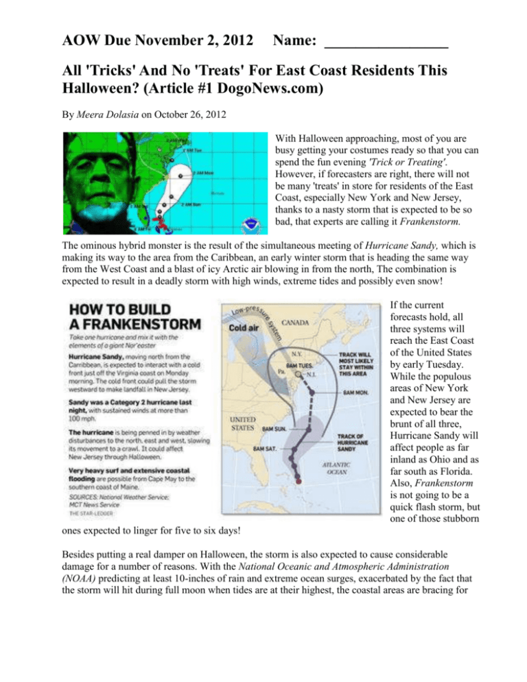
The ominous hybrid monster is the result of the simultaneous meeting of Hurricane Sandy, which is
making its way to the area from the Caribbean, an early winter storm that is heading the same way
from the West Coast and a blast of icy Arctic air blowing in from the north, The combination is
expected to result in a deadly storm with high winds, extreme tides and possibly even snow!
If the current
forecasts hold, all
three systems will
reach the East Coast
of the United States
by early Tuesday.
While the populous
areas of New York
and New Jersey are
expected to bear the
brunt of all three,
Hurricane Sandy will
affect people as far
inland as Ohio and as
far south as Florida.
Also, Frankenstorm
is not going to be a
quick flash storm, but
one of those stubborn
ones expected to linger for five to six days!
Besides putting a real damper on Halloween, the storm is also expected to cause considerable
damage for a number of reasons. With the National Oceanic and Atmospheric Administration
(NOAA) predicting at least 10-inches of rain and extreme ocean surges, exacerbated by the fact that
the storm will hit during full moon when tides are at their highest, the coastal areas are bracing for
some major flooding. NOAA is also expecting up to 2-inches of snow in West Virginia, which could
result in major power outages given that the trees are still green.
Many experts are comparing it
to the Perfect or Halloween
Storm of October 1991 that hit
areas of New England and
Canada and was caused by
Hurricane Grace coming in
from Bermuda and clashing
with a massive low pressure
system from Canada. However,
others fear this could be much
worse and that the destruction
caused will be closer to $1
billion USD as compared to the
$200 million USD in 1991.
While authorities and residents
are trying to prepare the best
they can for all kinds of
emergencies, there is really no
telling what may happen when nature unleashes its fury.
Thankfully, weather forecasting is not a perfect science and any one of these storms could lose
intensity on their way there - We sure hope that is the case, but we will only find out for sure on
Tuesday, November 30th, when Frankenstorm hits the shores of New Jersey!
By: Trent Magill, newsnet5.com
Article #2 WEWS From News Channel 5 - Cleveland
CLEVELAND - After a week of sunshine and near record-breaking warmth, our treat is ending and
the tricks are coming out to play.
The first indication of this is the cold front that pushed through Friday morning. This is the initial
cool down we have been expecting.
Temperatures will stay in the 40s through the weekend thanks to clouds, north winds and periods of
rain.
Typically, systems will only impact us for a day or so but the models are trending a bit slow for this
one, thanks to Hurricane Sandy in the Atlantic.
As Sandy slides north up the East Coast, it will shove abundant moisture our direction. This is
slowing our weekend system down. As Sandy merges with the cold front, we can expect several
days with off-and-on rain along with an increase in wind on Tuesday.
Timing and location of Sandy's path is vital to how much cold air we have in place and how long the
wind sticks around. The most reliable models keep northeast Ohio above the crucial freezing mark
through next week, so plan for mainly rain, but a wet snow flake is possible late Tuesday into
Halloween morning.
If Sandy's track stays farther east, the cold air will settle into Ohio giving us a much better shot at
snow next week.
Needless to say, we will be here monitoring the situation and narrowing down the forecast with each
new model run to give you the most updated and accurate forecast.
Copyright 2012 Scripps Media, Inc. All rights reserved. This material may not be published,
broadcast, rewritten, or redistributed.
Article #3 – WKYC Associated Press downloaded from WKYC.com
WASHINGTON -- The storm that is threatening 60 million Americans in the eastern third of the
nation in just a couple of days with persistent high winds, drenching rains, extreme tides, flooding
and probably snow is much more than just an ordinary weather system. It's a freakish and
unprecedented monster.
What forces created it?
Start with Sandy, an ordinary late summer hurricane from the tropics, moving north up the East
Coast. Bring in a high pressure ridge of air centered around Greenland that blocks the hurricane's
normal out-to-sea path and forces it west toward land.
Add a wintry cold front moving in from the west and colliding with that storm. Mix in a blast of
Arctic air from the north. Add a full moon and its usual effect, pulling in high tides. Factor in
immense waves commonly thrashed up by a huge hurricane plus massive gale-force winds.
Do all that and you get a stitched-together weather monster expected to unleash its power over 800
square miles, with predictions in some areas of 12 inches of rain, 2 feet of snow and sustained 40- to
50 mph winds.
"The total is greater than the sum of the individual parts" said Louis Uccellini, the environmental
prediction chief of the National Oceanic and Atmospheric Administration meteorologists. "That is
exactly what's going on here."
This storm is so dangerous and so unusual because it is coming at the tail end of hurricane season
and beginning of winter storm season, "so it's kind of taking something from both - part hurricane,
part nor'easter, all trouble," Jeff Masters, director of the private service Weather Underground, said
Saturday.
With Sandy expected to lose tropical characteristics, NOAA is putting up warnings that aren't
hurricane or tropical for coastal areas north of North Carolina, causing some television
meteorologists to complain that it is all too confusing. Nor is it merely a coastal issue anyway. Craig
Fugate of the Federal Emergency Management Agency told reporters Saturday: "This is not a coastal
threat alone. This is a very large area. This is going to be well inland."
It's a topsy-turvy storm, too. The far northern areas of the East, around Maine, should get much
warmer weather as the storm hits, practically shirt-sleeve weather for early November, Masters and
Uccellini said. Around the Mason-Dixon line, look for much cooler temperatures. West Virginia and
even as far south as North Carolina could see snow. Lots of it.
It is what NOAA forecaster Jim Cisco meant Thursday when he called it "Frankenstorm" in a
forecast, an allusion to Mary Shelley's gothic creature of synthesized elements.
Monday
1. Why are the forecasters calling the predicted storm “Frankenstorm, and who created the term?” Tell
which article you found the answer in (According to the article titled _________) it is called Frankenstorm
because… (2 points)
2. What are the three different systems that forecasters expect to combine on the East Coast and when is it
expected to happen (According to these articles?) (4 points)
3. There is a high pressure system in Greenland that is part of the cause of the storm. What is the
anticipated effect of this high pressure system?
A. It will bring hot temperatures to New York City.
B. It will bring freezing temperatures to Maine.
C. It will block the path of Hurricane Sandy so it can’t move out to the ocean.
D. It will block the path of the winter storm so it will create more snow in New York and New Jersey.
Tuesday
4. What is the text structure of Article 1. Provide examples from the text to support your answer. (2 pts)
5. Why does this weather system have the potential to be so dangerous?
A. It can be potentially dangerous because it can last for several days.
B. It can be potentially dangerous because there will be strong storm surges.
C. It can be potentially dangerous because it is coming at the end of the hurricane season and the beginning
of the winter storm season.
D. All of the above.
6. Many experts are comparing it to the Perfect or Halloween Storm of October 1991 that hit
areas of New England and Canada and was caused by Hurricane Grace coming in from
Bermuda and clashing with a massive low pressure system from Canada. However, others fear
this could be much worse and that the destruction caused will be closer to $1 billion USD as
compared to the $200 million USD in 1991. While authorities and residents are trying to
prepare the best they can for all kinds of emergencies, there is really no telling what may
happen when nature unleashes its fury.
This paragraph from one of the articles is written in a particular text structure. What is the text
structure? How do you know? What signal words are in the paragraph that helps you determine the
text structure? How does this text structure help you understand the article better?
Wednesday
1. What are some of the effects of Frankenstorm that forecasters are predicting? Tell which article you
found the answers in.
________________________________________________________________________________________
________________________________________________________________________________________
________________________________________________________________________________________
2. What do you think people on the East Coast could do to prepare to the storm? _____________________
________________________________________________________________________________________
________________________________________________________________________________________
________________________________________________________________________________________
3. Do forecaster know for sure where, when and what will happen with the three storm systems? How do
you know – support your answer using information from the articles. _______________________________
________________________________________________________________________________________
________________________________________________________________________________________
________________________________________________________________________________________
Thursday
1. What is the difference between last week’s weather and the weather forecasted for this week?
________________________________________________________________________________________
________________________________________________________________________________________
________________________________________________________________________________________
2. According to one of the articles, Ohio might not get snow because temperatures will stay above the
freezing point. Why does this mean that we won’t get snow? _____________________________________
________________________________________________________________________________________
________________________________________________________________________________________
________________________________________________________________________________________
3. Schools officials closed school on Sunday for Monday and Tuesday. Do you think this was a wise
decision? Why or why not? ________________________________________________________________
________________________________________________________________________________________
________________________________________________________________________________________
________________________________________________________________________________________
Criteria
Complete sentences, parts of the
question are used in your answer,
you use one of the sentence
stems
Correct answers to questions
Underlined answers in the
articles, underlined important
words in the questions
Grade
Comments:
Possible Points
Your Points
