9. Earth imagery and topographic maps
advertisement
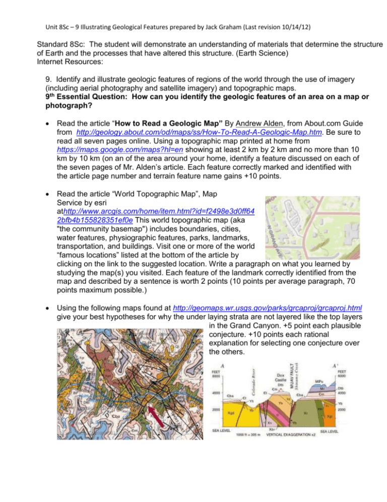
Unit 8Sc – 9 Illustrating Geological Features prepared by Jack Graham (Last revision 10/14/12) Standard 8Sc: The student will demonstrate an understanding of materials that determine the structure of Earth and the processes that have altered this structure. (Earth Science) Internet Resources: 9. Identify and illustrate geologic features of regions of the world through the use of imagery (including aerial photography and satellite imagery) and topographic maps. 9th Essential Question: How can you identify the geologic features of an area on a map or photograph? Read the article “How to Read a Geologic Map” By Andrew Alden, from About.com Guide from http://geology.about.com/od/maps/ss/How-To-Read-A-Geologic-Map.htm. Be sure to read all seven pages online. Using a topographic map printed at home from https://maps.google.com/maps?hl=en showing at least 2 km by 2 km and no more than 10 km by 10 km (on an of the area around your home, identify a feature discussed on each of the seven pages of Mr. Alden’s article. Each feature correctly marked and identified with the article page number and terrain feature name gains +10 points. Read the article “World Topographic Map”, Map Service by esri athttp://www.arcgis.com/home/item.html?id=f2498e3d0ff64 2bfb4b155828351ef0e This world topographic map (aka "the community basemap") includes boundaries, cities, water features, physiographic features, parks, landmarks, transportation, and buildings. Visit one or more of the world “famous locations” listed at the bottom of the article by clicking on the link to the suggested location. Write a paragraph on what you learned by studying the map(s) you visited. Each feature of the landmark correctly identified from the map and described by a sentence is worth 2 points (10 points per average paragraph, 70 points maximum possible.) Using the following maps found at http://geomaps.wr.usgs.gov/parks/grcaproj/grcaproj.html give your best hypotheses for why the under laying strata are not layered like the top layers in the Grand Canyon. +5 point each plausible conjecture. +10 points each rational explanation for selecting one conjecture over the others. Unit 8Sc – 9 Illustrating Geological Features prepared by Jack Graham (Last revision 10/14/12) Read the article “INTRODUCTION TO SURFACE GEOLOGICAL MAPPING IN A GEOTHERMAL ENVIRONMENT” by Dr. Peter A. Omenda retrievable from http://www.os.is/gogn/unu-gtp-sc/UNU-GTP-SC-10-0104.pdf to determine the features that should be included for geothermal area mappings. Use https://maps.google.com/maps?hl=en as your source for satellite and topographic maps of one of Unzen, Nagasaki Prefecture, Japan, or Mount Aso, Aso, Kumamoto Prefecture, Japan, or similar area around Beppu, Oita Prefecture, Japan. Visit the area of your choice with your family on a weekend or during the holidays. Take lots of pictures. Mark where each picture is on your map. From your pictures, your observations, and the information in the article by Dr. Omenda, mark appropriate geothermal activity on your copy of the Google topographic map of your area. +10 points each feature photographed, correctly identified, and marked on your map. Select an area you are familiar with anywhere in the world. Make a 3d map out of layers of poster board, cardboard, or box-board by cutting the poster board to the shape following the topographic lines on a copy of the topographic map of your area. Glue the layers together to make the mountains as in the picture at the right. Each piece you cut out within ± 1/10th of an inch of the shape shown by your map is worth one point. The brown map model at the right is worth 31 points as it is. If you add appropriate color showing roads, vegetation, etc, each piece doubles in value. If this model was properly colored as shown in the lower picture, then it would be worth 62 points. If you also show geologic data (the white tags) such as hot springs, volcanic vents, rock strata or rock types in the location mapped, then each such datum adds 2 points to the finished model’s score up to 100 points.


