Life`s Oldest Footprints
advertisement
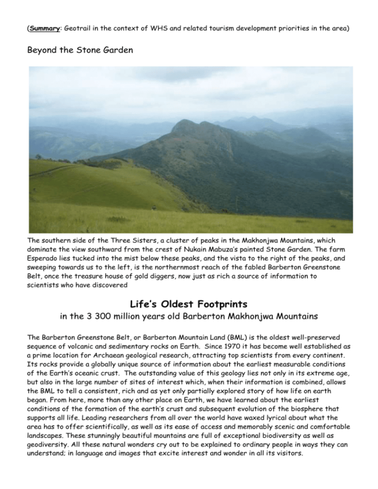
(Summary: Geotrail in the context of WHS and related tourism development priorities in the area) Beyond the Stone Garden The southern side of the Three Sisters, a cluster of peaks in the Makhonjwa Mountains, which dominate the view southward from the crest of Nukain Mabuza’s painted Stone Garden. The farm Esperado lies tucked into the mist below these peaks, and the vista to the right of the peaks, and sweeping towards us to the left, is the northernmost reach of the fabled Barberton Greenstone Belt, once the treasure house of gold diggers, now just as rich a source of information to scientists who have discovered Life’s Oldest Footprints in the 3 300 million years old Barberton Makhonjwa Mountains The Barberton Greenstone Belt, or Barberton Mountain Land (BML) is the oldest well-preserved sequence of volcanic and sedimentary rocks on Earth. Since 1970 it has become well established as a prime location for Archaean geological research, attracting top scientists from every continent. Its rocks provide a globally unique source of information about the earliest measurable conditions of the Earth’s oceanic crust. The outstanding value of this geology lies not only in its extreme age, but also in the large number of sites of interest which, when their information is combined, allows the BML to tell a consistent, rich and as yet only partially explored story of how life on earth began. From here, more than any other place on Earth, we have learned about the earliest conditions of the formation of the earth’s crust and subsequent evolution of the biosphere that supports all life. Leading researchers from all over the world have waxed lyrical about what the area has to offer scientifically, as well as its ease of access and memorably scenic and comfortable landscapes. These stunningly beautiful mountains are full of exceptional biodiversity as well as geodiversity. All these natural wonders cry out to be explained to ordinary people in ways they can understand; in language and images that excite interest and wonder in all its visitors. Most South African geologists know about the BML but how many have visited and taken an active interest in it? And how many non-geologists know about it or are familiar with its stories? The stories these rocks tell are of interest to any enquiring mind; they are amazing and important and at the very frontier of scientific knowledge. The list of scientific papers about BML-based research over the last forty years is possibly unequalled from any other equivalent location (there were over 2 400 refereed papers by 2006). Based on this impressive scientific record, the BML was successfully proposed for World Heritage Site status with UNESCO in 2008. It is currently a ‘Tentative Listed’ World Heritage Site (WHS) and planning work, to complete its required Nomination Dossier for full WHS status, was initiated in 2009. A year later the planning funds from the Provincial Government unexpectedly dried up. Simultaneously other sources of funding for job creation had been obtained by the Barberton Chamber of Business. With the planning stalled, these funds are currently being used to provide some of the tourism products and infrastructure needed to handle the increase in visitors expected once WHS status is achieved. Interpreting geology for the visiting public An early tourism development tackled by the Barberton Chamber of Business, via their project development agency BATOBIC (Barberton Tourism & Biodiversity Corridor), was the Makhonjwa Geotrail. This roadside geotrail takes advantage of the fresh road cuts on the newly surfaced 40 km mountain pass between Barberton and Bulembu in Swaziland. Some geosites close to Barberton had been identified by local GSSA members several years ago, and with the resurfacing creating fresh cut slopes, many new sites were exposed. Assisted by Prof Christoph Heubeck from Berlin Free University, who studied this route in detail in 1986 for his PhD, about twenty geosites and viewpoints were initially identified as having sufficient interest for visitors. Twelve of these were subsequently developed, accompanied by sophisticated roadside interpretative panels and literature. Landscape architects (V&L and New Leaf Landscape Architects from Pretoria) were employed to provide design elements and a landscaping company (Marina Landscaping of Durbanville, CT) was engaged to build the sites. A local firm of interpretative consultants (Hamilton-Fynch of Nelspruit) were also hired to design the roadside panels and the Geotrail Guidebook. High standards have been set as the facilities anticipate WHS status and therefore must hold their own against international competition and criticism. Although some incidents have already occurred, problems with vandalism and theft have been less than expected and are being managed by a small maintenance team. The Geotrail project was preceded by creation of two spectacular “Gateway” features at the two main-road intersections that lead into Barberton. These intersections had previously been populated by an ugly and unmanaged litter of advertising signs that have now been replaced by the Nukain Mabuza-inspired rock garden. This is seen by Fine Arts professionals as an excellent example of “living, Outsider art” that in principle may be allowed to change in the fullness of time and through the effects of weathering and ‘alteration’ by locals. This visually striking development directly preceded the Geotrail and is now an integral part of it. It served as a very successful stimulant of public interest and discussion about the tourism potential of the region. The target audience for the interpretative material is identified as, ‘interested adults to near-adults, with a reasonable secondary education (pre-matric) but no specific geological training’. The roadside panels and guide book texts not only address and vividly illustrate geological features and their meaning, but include appropriate biodiversity, wilderness, historic and cultural items of interest and, where possible, integrate and emphasise their connectedness. Panel information is targeted at the average nature-interested traveller, employing appropriate language and images. Their design has used multiple criteria for ease of comprehension of what is sometimes quite technical subject matter: aesthetic graphics, readability and simplified information content for different interest levels, and providing educational as well as recreational content. Panels are designed to embed geological information in its ecological, historical and cultural contexts. The Geotrail is a first for South Africa and probably for the whole continent. 1015 words Revised May 2015
