Acacia Ridge/Archerfield Neighbourhood Plan Code
advertisement
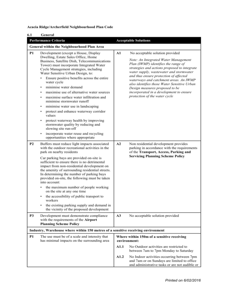
Acacia Ridge/Archerfield Neighbourhood Plan Code 6.1 General Performance Criteria Acceptable Solutions General within the Neighbourhood Plan Area P1 P2 Development (except a House, Display Dwelling, Estate Sales Office, Home Business, Satellite Dish, Telecommunications Tower) must incorporate Integrated Water Cycle Management strategies, including Water Sensitive Urban Design, to: • Ensure positive benefits across the entire water cycle • minimise water demand • maximise use of alternative water sources • maximise surface water infiltration and minimise stormwater runoff • minimise water use in landscaping • protect and enhance waterway corridor values • protect waterway health by improving stormwater quality by reducing and slowing site run-off • incorporate water reuse and recycling opportunities where appropriate A1 Buffers must reduce light impacts associated with the outdoor recreational activities in the park on nearby residents A2 Non residential development provides parking in accordance with the requirements of the Transport, Access, Parking and Servicing Planning Scheme Policy A3 No acceptable solution provided Note: An Integrated Water Management Plan (IWMP) identifies the range of strategies and actions proposed to integrate water supply, wastewater and stormwater and thus ensure protection of affected waterways and catchment areas. An IWMP also identifies those Water Sensitive Urban Design measures proposed to be incorporated in a development to ensure protection of the water cycle Car parking bays are provided on-site is sufficient to ensure there is no detrimental impact from non-residential development on the amenity of surrounding residential streets. In determining the number of parking bays provided on-site, the following must be taken into account: • the maximum number of people working on the site at any one time • the accessibility of public transport to workers • the existing parking supply and demand in the vicinity of the proposed development P3 Development must demonstrate compliance with the requirements of the Airport Planning Scheme Policy No acceptable solution provided Industry, Warehouse where within 150 metres of a sensitive receiving environment P1 The use must be of a scale and intensity that has minimal impacts on the surrounding area Where within 150m of a sensitive receiving environment: A1.1 No Outdoor activities are restricted to between 7am to 7pm Monday to Saturday A1.2 No Indoor activities occurring between 7pm and 7am or on Sundays are limited to office and administrative tasks or are not audible or Printed on 6/02/2016 visible from outside the building P2 6.2 Traffic generated by the use must not result in environmental nuisance or adversely impact on the safety of road users and residents Where within 150m of a sensitive receiving environment: A2.1 Heavy vehicle movements are restricted to between 7am to 7pm Monday to Saturday A2.2 All haul routes and on-site manoeuvring areas are sealed 4.8 – Jackson Road Precinct Performance Criteria Acceptable Solutions P1 A1.1 Development is concentrated outside the areas identified as Endangered Regional Ecosystem A1.2 An acoustic buffer is provided along the boundary with industrial land in accordance with the Noise Impact Assessment Planning Scheme Policy 6.3 Development for community activity purposes must be designed to protect and enhance the significant vegetation values of the precinct, and maintain a visual and acoustic buffer to the adjoining industrial uses 4.19 – Learoyd Road Precinct Performance Criteria Acceptable Solutions P1 A1 6.4 Residential development must be designed to protect and enhance the ecological functions and natural values of the precinct Residential development is located outside of the: • waterway corridors • a areas of regionally significant stands of Corymbia henryi • areas of remnant regionally endangered vegetation as shown on Map J 4.14 – Hellawell Road Precinct Performance Criteria Acceptable Solutions P1 A1 6.5 Residential development must integrate with the adjoining road network and provide: • safe pedestrian and cycle access from the residential uses to the Convenience Centre and bus stops • a permeable vehicular and pedestrian network connecting Jayef Street to Kingman Crescent and Hasler Crescent • safe vehicular lot access • minimise impacts by limiting direct vehicular access from lots to Jackson Road and/or Hellawell Road Significant native vegetation is retained and protected Development is consistent with: (a) Map F – Hellawell Road Residential Precinct 4.16a – Beaudesert Road Centre South – Elizabeth Street Sub–precinct Performance Criteria Acceptable Solutions P1 A1.1 A pedestrian and cycle path is provided linking Elizabeth Street to Chardean Street A1.2 Development provides an active building frontage along Mitchell Street, Elizabeth Building design, continuity and connectivity of streetscape, pedestrian paths street frontages must promote integration with the surrounding area and the rest of the Centre Printed on 6/02/2016 Development must establish a safe highquality pedestrian environment along Mitchell Street, Beaudesert Road, Elizabeth Street and Chardean Street P2 6.6 Building scale and bulk of the buildings must be consistent with buildings in locality Street, Chardean Street and to the pedestrian and cycle path resulting from A1.1 A1.3 Vehicular access to the site is limited to either Chardean Street, Mitchell Street or Elizabeth Street A2.1 Development (including non-residential only, residential only and mixed residential/non-residential) is a maximum of 3 storeys and 10.5m in height A2.2 Development (including non-residential only, residential only and mixed residential/non-residential) has a maximum plot ratio of 1.25 x the site area 4.16b – Beaudesert Road Centre North – O’Conner Street Sub–precinct Performance Criteria Acceptable Solutions P1 A1 Establish a safe high-quality pedestrian path on Beaudesert Road Development results in an active building frontage along Beaudesert Road Note: If public access is established to the Technical and Trades Training Precinct via the railway corridor and local roads safe, high-quality pedestrian links will be required 6.7 4.17a – Postle Street – Kerry Road Sub–precinct Performance Criteria Acceptable Solutions P1 A1.1 Heavy vehicle transport routes to the precinct are limited to Beaudesert Road or Kerry Road A1.2 Vehicle access to the Ddevelopment is limited to Postle Street in accordance with the desired access and internal road layout onconsistent with Map I 6.8 Industrial development must minimise impact on: • the operation and flow heavy vehicular traffic along Beaudesert Road and Kerry Road • the amenity of the existing Postle Street residential area 4.17b – Postle Street – Convenience Centre Sub–precinct Performance Criteria Acceptable Solutions P1 A1 6.9 Development provides a transition in built form to complement the scale of nearby residential areas Building height is limited to a maximum of 2 storeys and 8.5m in height where located within 10m of the boundary adjoining the residential sub-precinct 4.17(c) 4.18a – Coopers Plains Centre/Office and Industry – Coopers Plains Station Centre Sub–precinct Performance Criteria Acceptable Solutions P1 A1.1 Buildings along Henley Street are built to the front boundary A1.2 Buildings incorporate: • parapets above footpath awnings • awnings over the footpath along the length of the frontage • glazing design to include a 600-800mm painted wall panel at the lowest part of Development of the shopping centre at the corner of Henley Street and Boundary Road, or the sites adjacent to the identified heritage place, must complement the architectural style and character in terms of building form, scale, materials (‘timber and tin’) and signage Printed on 6/02/2016 the ground level streetscape elevation 6.10 A1.3 External building materials include: • painted masonry or timber materials to all wall surfaces • custom-orb profile metal sheeting for the roof A1.4 Car parking is provided at the rear of the site, to minimise visual impact from the driveway entries, car parking and servicing areas A1.5 Future road infrastructure works must maintain accessibility to this centre from Boundary Road 4.2 – Archerfield North Precinct – (Granard Road Sub-precinct) Performance Criteria Acceptable Solutions P1 A1.1 Industrial development can only occur as a result of whole amalgamated site areas being developed in their entirety as shown on Map D A1.2 Site area B can be developed for industrial development once site areas A or C are developed A1.3 Where a site area, developed for industrial uses, adjoins residential uses – a buffer must be provided including 5m of landscaping fronting the separating road between the two sites and an acoustic fence behind the landscaping Industrial development is not appropriate within a residential area nor when it results in the fragmentation and isolation of residential areas. Industrial development must be large in size and consolidated in area to ensure that industrial development can protect residential amenity Industrial development must not result in areas of isolated residential use within the precinct, as residential amenity is likely to be compromised Note: Once the adjoining site is developed for industrial uses (i.e. no longer residential) the buffer can be removed and used for industrial purposes P2 In the development of sites for industrial uses, a Masterplan must be prepared over the whole precinct (sites A, B and C) that demonstrates management of the following aspects: • significant visual and acoustic buffering to residential uses in the adjoining sites • on-site car parking • vehicular access • traffic management to minimise impacts of adjoining residential sites • on-site manoeuvring for heavy vehicles • visual and physical connections to EC Blackwell Park • appropriate building height and setbacks • no direct vehicular access to Granard Road • pedestrian linkages to public transport • landscaping • on-site recreation for workers A2 No acceptable solution provided Printed on 6/02/2016 • • P3 hours of operation (where adjacent to a sensitive receiving environment) management of environmental impacts (air, noise and visual) Development must provide parkland that results in a safe and highly visible link from Amaroo Street, through EC Blackwell Park to Beatty Road A3 In site B, parkland is provided in accordance with Map D A4 No acceptable solution provided Note: The parkland must meet the requirements of the Crime Prevention Through Environmental Design Planning Scheme Policy P4 6.11 Development that adjoins EC Blackwell Park, must provide: • a building design that provides for activity at the adjoining boundary with the park • a building, site layout and fence design that facilitates surveillance of the park • direct access to the park for employees 4.3 – Archerfield East Precinct – (4.3a - Desgrand Street Sub-precinct) Performance Criteria Acceptable Solutions P1 A1.1 Industrial development can only occur as a result of whole amalgamated site areas being developed in their entirety as shown on Map E A1.2 Where a site area, developed for industrial uses, adjoins residential uses – a buffer must be provided including 5m of landscaping fronting the separating road between the two sites and an acoustic fence behind the landscaping Industrial development is not appropriate within a residential area nor when it results in the fragmentation and isolation of residential areas. Industrial development must be large in size and consolidated in area to ensure that industrial development can protect residential amenity Industrial development must not result in areas of isolated residential use within the precinct, as residential amenity is likely to be compromised P2 In the development of sites for industrial uses, a Masterplan must be prepared over the whole precinct (sites A and B) that demonstrates management of the following aspects: • significant visual and acoustic buffering to residential uses in the adjoining sites • on-site car parking • vehicular access • traffic management to minimise impacts of adjoining residential sites • on-site manoeuvring for heavy vehicles • visual and physical connections to Archerfield Park • appropriate building height and setbacks • preserve vehicular access to Kerry and Boundary Roads Note: Once the adjoining site is developed for industrial uses (i.e. no longer residential) the buffer can be removed and used for industrial purposes A2 No acceptable solution provided Printed on 6/02/2016 • • • • • P3 6.12 pedestrian linkages to public transport landscaping on-site recreation for workers hours of operation (where adjacent to a sensitive receiving environment) management of environmental impacts (air, noise and visual) Development that adjoins Archerfield Park, must provide: • a building design, site layout and fencing design that provides activity at the boundary with the park and facilitates surveillance • direct access to the park for employees A4 No acceptable solution provided Coopers Plains Precinct – 4.15 Performance Criteria Acceptable Solutions Multi-Unit Dwelling on sites identified in the Coopers Plains Precinct Map G: P1 Development size and bulk must result in a low-medium to medium density building form that minimises impacts, including excess overshadowing and overlooking on adjoining low and low-medium density developments A1.1 Building height is consistent with the outcomes stated in Map G A1.2a Building height is limited to a maximum height of 3 storeys where located within 10m of the boundary of a site containing an existing house OR A1.2b A landscape buffer of 2m incorporating dense screening species (established to 5.0m height) is provided to any boundary of a site containing an existing house While every care is taken by Brisbane City Council to ensure the accuracy of this extract of the code, Council make no representations or warranties about its accuracy, reliability or completeness and disclaim all responsibility and all liability (including without limitation, liability in negligence) for all expenses losses and damages (including direct and consequential damage) and costs that may be incurred as a result of the document being inaccurate in any way and for any reason. Printed on 6/02/2016


