lesson 4 Aral Sea - SLC Geog A Level Blog
advertisement
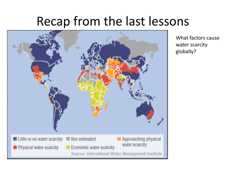
Recap from the last lessons What factors cause water scarcity globally? Learning Objectives • To consider how the global water crisis is linked to economic, social (especially health) and political issues • To understand why the Aral sea is water scarce and the role of different key players. • To understand the impacts this has had on human welfare and economic growth Read p 62-67 Oxford • Produce an A3 spider diagram to show how the global water crisis is linked to economic, social (especially health) and political issues • Make sure you put named examples Water scarcity hotspots According to the International Water Management Institute environmental research organisation global water stress is increasing, and 1/3 rd of all people face some sort of water scarcity. Agricultural uses dominate in the growing need for food. Aral Sea faces environmental catastrophe, although recent attempts to reduce impacts of river diversions for especially cotton production Egypt imports > 50% of its food because of physical scarcity Ogallala aquifer provides 1/3 all US irrigation water, but is seriously depleted: the water table is dropping by about 1m/yr. As a ‘fossil’ reserve, formed probably from past glacial meltwater flows, it is effectively a finite resource Severe water scarcity N China, leading to South North transfer scheme-see later slide R Ganges: physical stress from pollution and over abstraction Australia; diversion ¼ of all water away from Murray Darling Basin for agriculture Much of sub Saharan Africa suffers from economic scarcity from especially poverty but also lack of infrastructural development . Some 1 bn people involved1 Little/no water scarcity Physical water scarcity- not necessarily dry areas but those where over 75% river flows are used by agriculture, industry or domestic consumers Economic water scarcity- less than 25% rivers used, and abundant supply potential but not reaching the poorest people . Approaching physical water scarcity – More than 60% river flows allocated, and in the near future these river basins will have physical scarcity Water conflicts Population growth Consumer demand Industrial growth Agricultural demand DEMANDS? SUPPLY? Rising Diminishing DIFFERENT USERS? Conflicting demands •International conflicts i.e. basin crosses national boundaries •Internal conflicts ie within a country •Conservation versus exploitation Reductions because of: •Users abstracting/polluting upstream •Deteriorating quality •Impact of climate change PRESSURE POINT- ie need for management. This is shown spatially as a ‘hotspot’ of conflict, see map on next slide. Pressure and hence tension and conflict may be over surface flow and/or groundwater supplies Dams and diversions and loss of wetlands are particularly contested. Present and potential water conflict hotspots • • As water supply decreases, tensions will increase as different players try to access common water supplies Many conflicts are transboundary in nature, either between states or countries River basins currently in dispute Tigris-Euphrates Iraq + Syria concerns that Turkey’s GAP project will divert their water Colorado: disputes between the 7 US states and Mexico it flows through. The river is so overused, that it no longer reaches the sea!. 90% abstracted before reaches Mexico River basins at risk in the future Large International drainage basins Ob Lake Chad Mekong Ganges Okavango La Plata Zambezi Insert Figure 2.11 Orange page 47 Note: although there have been rising tensions globally, many areas demonstrate effective management to diffuse the situation and create more equitable and sustainable demand-supply balance, such as the Mekong River Committee,& the Nile River Initiative Nile hotly disputed between Ethiopia and Sudan ,who control its headwaters, and Egypt . The Aral Sea, an inland drainage basin, once the world’s 4th largest inland lake has shrunk sine the 1950s after the 2 rivers feeding it: the Amu Dayra and Syr Darya were diverted for irrigation. By 2007 the sea was 10% of original volume and split into 2 lakes. The ex soviet states are in conflict: Uzbekistan , Turkmenistan and Kazakstan. Aral Sea Why? ‘With reference to differing examples, explain how differing stakeholders views could lead to water conflict’ (15) Aral Sea Over time Background from Internet • • • • • • Once the world's fourth-largest saline body of water with an area of 68,000 km2, the Aral Sea has been steadily shrinking since the 1960s, after the rivers Amu Darya and Syr Darya that fed it were diverted by Soviet Union irrigation projects (in what are now Kazakhstan, Uzbekistan, and Turkmenistan) to irrigate farmland. As its water levels dropped, the lake began splitting into smaller pieces: the Northern (Small) Aral Sea and the Southern (Large) Aral Sea. The Southern Aral Sea further split into eastern and western lobes. By 2007 it had declined to 10% of its original size, splitting into three separate lakes, two of which are too salty to support fish. The once prosperous fishing industry has been virtually destroyed, and former fishing towns along the original shores have become ship graveyards. With this collapse has come unemployment and economic hardship. By August 2009 virtually nothing remained of the Southern Aral Sea’s eastern lobe. Much of what finally doomed the Southern Aral Sea was an attempt to save its neighbour to the north. In 2005, Kazakhstan built the Kok-Aral Dam between the lake’s northern and southern portions to preserve water levels in the north. The Northern Aral Sea actually exceeded expectations with the speed of its recovery, but the dam ended prospects for a recovery of the Southern Aral Sea, which some authorities already regarded as beyond help. The Aral Sea is also heavily polluted, largely as the result of weapons testing, industrial projects, pesticides and fertilizer runoff. Wind-blown salt from the dried seabed damages crops and polluted drinking water and salt- and dust-laden air cause serious public health problems in the Aral Sea region. The retreat of the sea has reportedly also caused local climate change, with summers becoming hotter and drier, and winters colder and longer. June 2013 Tasks Make notes or answer the following questions on the Aral Sea : 1. Why was it exploited? 2. Which stakeholders thought it was a good idea to exploit – for each say briefly why? 3. Which stakeholders are against the exploitation why? 4. What are the human welfare impacts of the exploitation of the Aral Sea? 5. What are the economic impacts of the Aral sea exploitation? Information • http://en.wikipedia.org/wiki/Aral_Sea • http://www.telegraph.co.uk/news/worldnews /asia/kazakhstan/9012718/Will-the-Aral-Seaever-return.html • http://www.youtube.com/watch?v=dp_mlKJi wxg • http://en.tengrinews.kz/environment/Kazakhs tan-enters-second-phase-of-Aral-Searestoration-14538/ Solutions to the Aral sea water problem? Many different solutions to the different problems have been suggested over the years, varying in feasibility and cost, including: • Improving the quality of irrigation canals • Installing desalination plants • Charging farmers to use the water from the rivers • Using alternative cotton species that require less water • Using fewer chemicals on the cotton • Moving farming away from cotton • Installing dams to fill the Aral Sea • Redirecting water from the Volga, Ob and Irtysh Rivers to restore the Aral Sea to its former size in 20–30 years at a cost of US$30–50 billion[ • Pumping sea water into the Aral Sea from the Caspian Sea via a pipeline, and diluting with freshwater from local catchment areas • In January 1994, the countries of Kazakhstan, Uzbekistan, Turkmenistan, Tajikistan and Kyrgyzstan signed a deal to pledge 1% of their budgets to helping the sea recover. • In March 2000, UNESCO presented their "Water-related vision for the Aral Sea basin for the year 2025"[ at the second World Water Forum in The Hague. • By 2006, the World Bank's restoration projects, especially in the North Aral, were giving rise to some unexpected, tentative relief in what had been an extremely pessimistic picture.
