Shasta River Watershed Stewardship Approach
advertisement
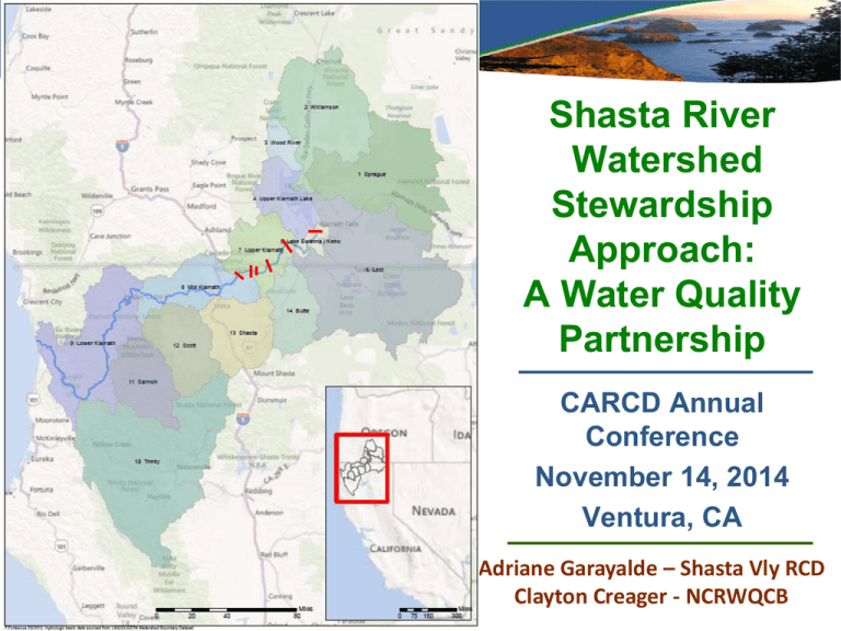
Shasta River Watershed Stewardship Approach: A Water Quality Partnership CARCD Annual Conference November 14, 2014 Ventura, CA Adriane Garayalde – Shasta Vly RCD Clayton Creager - NCRWQCB Presentation Overview The Shasta River Watershed Shasta Valley RCD mission and purpose Shasta River TMDL – Temperature & DO The Watershed Stewardship Approach Shasta Valley Watershed Stewardship Partners Shasta Valley Watershed Management Issues Watershed Stewardship Projects Will the Stewardship Approach Work for Other RCDs? Shasta Valley RCD Mission and Purpose Mission Statement To work with interested landowners on a voluntary basis to enhance the management and sustainable use of natural resources in order to ensure the long term economic viability of the community. Vision Statement We believe that by working together with landowners we can help the people within the District to meet the environmental and economic challenges they face. Value Statement The Shasta Valley Resource Conservation District will approach all interactions with funders, partners, agencies and members of the public with professionalism, integrity, fairness, respectfulness and an open mind. Klamath Basin TMDLs Sprague, Williamson, Upper Klamath Lake, 2002 (temp, DO, pH, Chl(a)) Lost River, 2010 (pH, NH3, DO, temp) Klamath, 2010 (pH, nutrients, DO, temp, Chl(a), microcystin) Trinity S. Fork, 1998 (sed) Trinity, 2001 (sed) Salmon, 2005 (sed, temp) Scott, 2005 (sed, temp) Shasta, 2006 (DO, temp) Lost, 2008 (nutrients, pH) 2010 Shasta River Sub-Basin And Tributaries Watershed Stewardship Area Shasta River Watershed Shasta River watershed is approximately 800 square miles Shasta River is a spring-fed river (cold, nutrient rich water) Dwinnell Dam was constructed in 1928 Shasta Basin - 11% (60,000 acres) of land in irrigated production and 23% (120,000 acres) in grazed ranchland Surface water resources are over allocated during the summer months Challenges managing resource needs of threatened coho salmon (Oncorhynchus kisutch) Why Watershed Stewardship Approach? Watershed Stewardship Framework Shared environmental Landowners Siskiyou County NOAA NMFS CA Trout NCRWQCB CDFW outcomes Common management strategies Leverage available resources Streamline requirements and process Forum to resolve misunderstandings and conflicts Watershed Stewardship Approach Goals and Objectives: Broader participation; Comprehensive assessments to support problem identification and project priorities; Increased transparency and distribution of watershed stewardship information; Coordinated funding and activities; Improved tracking and documentation; Use of adaptive management principles; and Improved and optimized monitoring networks; Watershed Stewardship Framework An approach that supports collaborative outcomes Adaptive Management Framework Implement Actions (All) Watershed Stewardship Teams Adjust (All) Evaluate (All) Certifies & Registers Projects Track & Account (KTAP) Monitor (KBMP) Water Quality Conditions Klamath Basin Monitoring Program Monitoring coordination Common analytical methods and sampling protocols Data management Membership organization Watershed stewardship assessment reports Web Information Portal (Blue-green Algae Tracker) www.kbmp.net Klamath Tracking & Accounting Program (KTAP) KTAP - Program Components Quantification Methods October 2014 Consistent Protocols Tracking/ Registration Klamath Tracking and Accounting Program Shasta Valley Watershed Stewardship Partnership Contributors Shasta Valley RCD Klamath Basin Monitoring Program Regional Water Board CA Fish & Wildlife The Nature Conservancy US Fish & Wildlife Service City of Yreka NOAA Fisheries Karuk Tribe Cal Trout US EPA Region 9 SWRCB Water Rights Division USFS – Klamath & Shasta Trinity USGS Individual Landowners / Ranchers Montague Water Conservation District Pending or Planned Outreach City of Weed US BLM CalTrans City of Montague Local Interest Groups Community of Edgewood Community of Shastina Stewardship Priorities Water Quality Issues of Concern Grazing impacts Riparian vegetation management Minor impoundments Water Use / TMDL flow objective Irrigation / Tailwater management Lake Shastina management Stormwater Roads Timber harvest Yreka Waste Water Treatment Plant Spring rehabilitation Stewardship Activities Water Quality Ranch Plans (TMDL Waiver) Riparian protection / fencing Tailwater management Riparian planting Irrigation management Water conservation / flow enhancements Small impoundment mitigation / fish barrier removal Watershed Stewardship Report http://www.kbmp.net/stewardship Tracking Stewardship Activities Stewardship Project Inventory Tributary Reach Project Implementation date Source Category Addressed Water Quality Improvement Project Sponsor Project Description Water Quality Ranch Planning Important tool for landowners to manage for improved water quality 31 ranchers have completed plans 24 water quality ranch plans developed by SVRCD for TMDL purposes Continue to develop additional water quality ranch plans TMDL Grants and Contracts Phase I: Grant for tailwater analysis, project priority setting, tailwater reduction projects, and minor impoundment removal (2006-2007) Phase II: Tailwater Reduction (2009) Riparian Protection and Restoration (2011) Assessment and Planning Analysis in High Priority Area (2013) Phase III: Irrigation Water Management and Watershed Stewardship Project (2013) Annual small contracts to SVRCD (2006 – 2013 for coordinating work supportive of the TMDL) Watershed Stewardship Project Example Riparian Protection Shasta River at Louie Rd Bridge (RM 33.9). Fenced 2009 1997 2011 Watershed Stewardship Pilot Project Example Riparian Planting Watershed Stewardship Pilot Project Example Tailwater Projects 465 ac-ft Hidden Valley Ranch Tailwater Project 126 ac-ft Watershed Stewardship Pilot Project Example Minor Impoundment Removal Watershed Stewardship Monitoring Plan Existing Monitoring Entities: Shasta Valley RCD The Nature Conservancy / UC Davis US Forest Service CDFW McBain and Trush (CA SCC) Sierra Pacific Industries Emmerson NOAA Fisheries Watercourse Engineering Montague Water Conservation District Karuk Tribe Regional Water Board / US EPA IX City of Yreka Reach Breakpoints Shasta River 1) Mouth to Yreka Creek 2) Yreka Creek to Little Shasta River 3) Little Shasta River to Willow Creek 4) Willow Creek to Big Springs Creek 5) Big Springs Creek to Parks Creek 6) Parks Creek to Dwinnell Outlet 7) Lake Shastina 8) Lake Shastina to Headwaters Yreka Creek Oregon Slough Little Shasta River Big Springs / Little Springs Creek Parks Creek Water Quality Monitoring Sites Existing and Proposed Lessons Learned Resources to support outreach, coordination and communication activities are critical to success Working in a basin that is very polarized has challenges Integrating regulatory requirements into partnership is still a work in progress Documenting project implementation takes resources but has real value Adaptive management criteria remains to be completed Tracking status and trends takes several years of monitoring data The pilot project is generally viewed as a success in the watershed Questions?

