Airport Information
EHTX (Texel)
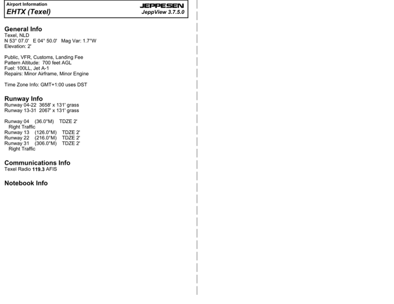
General Info
Texel, NLD
N 53° 07.0' E 04° 50.0' Mag Var: 1.7°W
Elevation: 2'
Public, VFR, Customs, Landing Fee
Pattern Altitude: 700 feet AGL
Fuel: 100LL, Jet A-1
Repairs: Minor Airframe, Minor Engine
Time Zone Info: GMT+1:00 uses DST
Runway Info
Runway 04-22 3658' x 131' grass
Runway 13-31 2067' x 131' grass
Runway 04 (36.0°M) TDZE 2'
Right Traffic
Runway 13 (126.0°M) TDZE 2'
Runway 22 (216.0°M) TDZE 2'
Runway 31 (306.0°M) TDZE 2'
Right Traffic
Communications Info
Texel Radio 119.3 AFIS
Notebook Info
JEPPESEN
JeppView 3.7.5.0
JEPPESEN
JeppView 3.7.5.0
Licensed to (unknown). Printed on 28 Sep 2014.
Notice: After 17 Oct 2014 0901Z, this chart may no longer be valid. Disc 20-2014
JEPPESEN
Notice: After 17 Oct 2014 0901Z, this chart may no longer be valid. Disc 20-2014
ARR
TEXEL
19-1
15 APR 11
EHTX
JEPPESEN
TEXEL
Within CTR (C) De Kooy:
DE KOOY TOWER
(AFIS)
TEXEL RADIO
NETHERLANDS
Elev 2'/1m
N53 07.0
E004 50.0
20
3.5 NM NNE Den Burg
120.12
TEXEL RADIO
ILS
119.30
For additional flight information
see Texel 19-1/19-2.
ILS
RWY
TEXEL
NETHERLANDS
(en)
From 01 APR until 30 SEP:
Special Arrival Routes on Sat, Sun and Hol.
119.30
RWY
TEXEL
19-1A
15 APR 11
(AFIS)
10
JEPPESEN
JeppView 3.7.5.0
Licensed to (unknown). Printed on 28 Sep 2014.
04-55
53-10
ARR 1502'
E
72'
53-10
15
04-40
*41,000' by NOTAM
72'
De Waal
A
-R4
EH
1
FL 150
4
1
04
/ 22
31
04
Cir
cu
it
1
53-05
53-05
2
| 2007 AND Data Solutions B.V.
| 2007 AND Data Ireland Limited.
011^
13
Oosterend
RDH
TMA (E)
Nieuw-Milligen A
FL 65*
1500'
*Fri 1700LT-Sun 2400LT
& Hol FL 95
04-50
1
Waddenzee
1
NM
VOR/D
M
115.55 E HDR
ee
nz r C
de do SF
a d rri 0 '
W Co 100
NM
M
De Waal
| JEPPESEN, 2007, 2011. ALL RIGHTS RESERVED.
Noorder Haaks
207'
R
AR
Horntje
Marsd
CTR (C)
De Kooy
3000'
SFC
iep
DEN HELDER
04-40
22
ATZ De
/1500 'AAKoo
C
F
S
5
53-00
Waddenzee
04-55
General
For the procedures on 19-1A/19-1B the following limits apply:
1. Visibility 5 KM and cloud base 1500' or above. Below these
limits the normal circuit procedures are applicable.
2. Touch-and-go's during mentioned period only on request.
3. Circuit altitude 1002'.
4. Approaches to the AD shall be made at 1502'.
5. Two-way radio contact shall be established with TEXEL
RADIO.
6. Request during op hr DE KOOY TWR for crossing
clearance De Kooy CTR.
7. Built-up areas shall be avoided as much as possible.
8. Parachute jumping may take place.
9. Reporting points:
A: 2 NM SE of the coast abeam Oosterend.
B: 2 NM SW of Oosterend.
C: 5 NM SW of THR 22.
D: 2 NM NE of Oosterend.
E: 4 NM NE of THR 04.
Arrival Routes RWY 13/31
- Proceed to the AD at 1502' or above.
- Avoid built-up areas.
- Join the standard circuit procedure.
- Circuit altitude 1002'.
CHANGES: VAR - Spot ELEV - Text.
Arrival Routes RWY 04/22
1. All reporting points and final are compulsory.
2. RWY 04, arriving from SE:
- Report over point A at 1502'.
- Proceed direct to point B; past B execute a
continuous descent to final RWY 04.
3. RWY 04, arriving from SW:
- Report over point C at 1502'.
- Start the descent for final RWY 04.
4. RWY 22, arriving from SE and De Kooy:
- Report over point A at 1502'.
- Turn right via coastline to point D.
- Turn left on a direct left hand base leg.
- Execute a continuous descent to final RWY 22.
5. RWY 22, arriving from NE:
- Report over point E at 1502'.
- Stay well clear of the built-up area (De
Cocksdorp).
- Proceed direct for a straight-in RWY 22.
| JEPPESEN, 2000, 2011. ALL RIGHTS RESERVED.
NM
2
EXIT 2
Circuit Marker
(orange)
3
Oost
53-00
T E X E L
L
De Koog
CHANGES: VAR - Airspace - Direction Arrow - Highest OBST.
A
Oudeschild
y
RW
Y
79'
DEN BURG
Waddenzee
km
MiddenEierland
79'
ARR 04
3/3
5
| 2007 AND Data Solutions B.V.
| 2007 AND Data Ireland Limited.
MNM 1000'
RW
Y1
83'
04
B
Den
Burg
14
Ar
ea
km
04
EXIT
22
*Mon-Fri 0900-1700,
EXC Hol: 1200'
ZuidEierland
10
Oost
Oosterend
Den Hoorn
1
13
Forest: | WorldSat International Inc., 2002
All Rights Reserved.
www.worldsat.ca
rea
D
ee
nz
de or
ad id
W Corr
TMZ
A
FL 195
FL 65*
uit
A
Altitudes in ft
Distances in NM
'
02
15
APR-SEP
Cir
c
0&
FL 150
C
6
60'
3
EXIT
31
5
Digital Geography
Europe:
0
15
AR
R
83'
De
Cocksdorp
De Slufter
MNM 1000'
04
De Koog
7
1
Zuid-Eierland
SEA
53-10
TEXEL
*Fri 1700LT-Sun 2400LT
& Hol FL 95
NORTH SEA
10
Traffic circuits 1002'
Altitudes in ft
Distances in NM
Digital Geography
Europe:
NORTH
ARR 22
TMA (E)
Nieuw-Milligen A
Above AD Texel
FL 65*
3500'
04-45
Midden-Eierland
MNM 1500' SFC
53-10
5
8
Waddenzee
31
1 Natural Area
De Cocksdorp
13
EH-R4D
1500'
SFC
04-50
22
04-45
ARR
MNM 1502'
0
EH-R4A
30,000' *
SFC
JEPPESEN
JeppView 3.7.5.0
Licensed to (unknown). Printed on 28 Sep 2014.
Notice: After 17 Oct 2014 0901Z, this chart may no longer be valid. Disc 20-2014
Notice: After 17 Oct 2014 0901Z, this chart may no longer be valid. Disc 20-2014
DEP
TEXEL
TEXEL
19-1B
TEXEL
NETHERLANDS
JEPPESEN
15 APR 11
Within De Kooy CTR (C):
DE KOOY TOWER
(AFIS)
TEXEL RADIO
120.12
19-2
NETHERLANDS
(PPR)
119.30
(FIS)
53-10
E
72'
04-40
DE
P
De Cocksdorp
132.35
DUTCH MIL INFO
Feet 0
04-55
15
JEPPESEN
15 APR 11
TEXEL
(en)
From 01 APR until 30 SEP:
Special Departure Routes on Sat, Sun and Hol.
For additional flight information
see Texel 19-1/19-2.
JEPPESEN
JeppView 3.7.5.0
Licensed to (unknown). Printed on 28 Sep 2014.
Meters 0
53-10
500
1000
200
1500
2000
400
2500
600
22
800
216
^
04
58
'
0
DE
P
83'
De Waal
FL 150
Oost
Oosterend
Den
Burg
km
DE P
Noorder Haaks
ee
nz
de o r
ad id
W Corr
CTR (C)
De Kooy
3000'
SFC
Horntje
53-00
04
036
iep
Marsd
06
7'
^
31
306
^
53-00
1 (O/R)
(limited)
TAXI
(limited)
(O/R)
Bicycle
THRL (for RWY in use if VIS is 5 KM or below).
DEN HELDER
04-55
RWY No
L
04
22
13
31
NM
y
ATZ De
/1500 'AAKoo
C
F
S
Waddenzee
Departure Routes RWY 04/32
1
1. Reporting points are non-compulsory.
Strength
1
Dimension (m) - Surface
TORA (m)
LDA (m)
1115 x 40 Grass
1115
1115
6t AUW/0.56 MPa
630 x 40 Grass
630
630
6t AUW/0.56 MPa
Lights
AD manager can admit ACFT with higher AUW and tyre pressure when surface conditions permit.
See also Natural Area Waddenzee (Wetland) in section 2.1 Regulations.
If weather conditions permit, pass the Texel coastline at MNM 1500'.
Descend to circuit altitude after passing the villages Oosterend and Oost.
Visual traffic circuits must be carried out within the shown areas appropriate to the RWY in use.
Traffic circuit altitude 1002'.
Joining and leaving the circuit shall take place in accordance with the rules of the standard circuit as laid down
in "Standard Traffic Circuit Procedure" (see section 3.2 Use of Aerodromes) except:
- RWY 22: After TKOF climb on RWY heading. At orange circuit marker make left hand turn to crosswind and
leave circuit as indicated on 19-1.
- RWY 04: After TKOF climb to 1000' on RWY heading. Leave the circuit as indicated on 19-1.
- RWY 31: Leave the circuit as indicated on 19-1.
The circuit area may not be overflown below 1502'.
The bird sanctuaries should not be overflown below 1000'.
Avoid overflying of built-up areas and dunes as much as possible. The marked areas must be avoided.
2. RWY 04, departing to the NE:
- Climb on RWY heading to 1500'.
- Avoid built-up areas.
3. RWY 04, departing to the SE:
- Climb on RWY heading to 1200'.
- Make a climbing right turn out to 1500'.
- Avoid built-up areas.
4. RWY 22, departing to the SW:
- Climb on RWY heading to 1500'.
- Avoid the built-up areas, especially Den Burg.
- Contact DE KOOY TWR for crossing the CTR.
5: RWY 22, departing to the SE:
- Climb on RWY heading to 1000'.
- Make a climbing left turn out to 1500' or above.
- Avoid built-up areas.
CHANGES: VAR - Spot ELEV - Text.
^
630
m2
5
22
79'
04-40
13
126
'
02
15
Oudeschild
Den Hoorn
| 2007 AND Data Solutions B.V.
| 2007 AND Data Ireland Limited.
Waddenzee
22
T
TWR
B
C
207'
C
10
T E X E L
5
Digital Geography
Europe:
Altitudes in ft
Distances in NM
D
111
5m
De Koog
04
31
Zuid-Eierland
SEA
DE
P0
4
22
10
13
NORTH
36
Midden-Eierland
CAUTION: Parachute jumping may take place. Grass cutting at irregular times.
| JEPPESEN, 2000, 2011. ALL RIGHTS RESERVED.
CHANGES: QFU - Buildings.
| JEPPESEN , 2007, 2011. ALL RIGHTS RESERVED.

