Alan`s NCAS talk_d18o (2)
advertisement
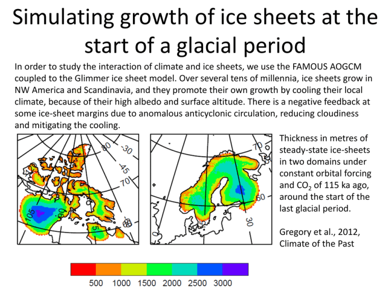
Simulating growth of ice sheets at the start of a glacial period In order to study the interaction of climate and ice sheets, we use the FAMOUS AOGCM coupled to the Glimmer ice sheet model. Over several tens of millennia, ice sheets grow in NW America and Scandinavia, and they promote their own growth by cooling their local climate, because of their high albedo and surface altitude. There is a negative feedback at some ice-sheet margins due to anomalous anticyclonic circulation, reducing cloudiness and mitigating the cooling. Thickness in metres of steady-state ice-sheets in two domains under constant orbital forcing and CO2 of 115 ka ago, around the start of the last glacial period. Gregory et al., 2012, Climate of the Past Next-generation climate—ice-sheet coupling for the Unified Model mm/day • Dynamic ice-sheets important in the Earth system on human timescales as well as paleoclimate • Mismatch of spatial/time resolution between ice-sheet and atmosphere /oceans makes coupled modelling a particular challenge • Coupling to Glimmer-CISM and BISICLES is in development Daily surface mass balance for Greenland compared to the last decade from the DMI regional model (beta.dmi.dk/en/groenland/maalinger/greenland-ice-sheetsurface-mass-budget) Pine Island Glacier, Antarctica, simulated on the adaptive mesh of the BISICLES ice-sheet model Next-generation climate—ice-sheet coupling for the Unified Model • Within NCAS, new scheme to explicitly model surface mass balance within JULES has been developed • Allows conservation of water/energy between climate and ice-sheet models • Subgridscale orography with multilayer snowpack models with prognostic albedo, refreezing of surface melt according to the density profile • Currently being evaluated in FAMOUS, HadRM3. Will be implemented in UK-EMS1 18 d O Modelling with the HaCM3 coupled atmosphere ocean GCM Useful for: • Interpreting palaeodata • Understanding the hydrological cycle (including attribution of recent changes) • Model assessment and validation Understanding past climates Instrumental record 1880-present d18O from Greenland ice cores (last 250ka) d18O from deep sea dwelling foraminifera What is 18 d O? All natural waters contains some oxygen-16 and some oxygen-18. Anything which incorporates water will incorporate some oxygen-16 and some oxygen18. d18O is a measurement of the relative amounts of oxygen-16 and oxygen-18. Different values of d18O are expected for different climates. Interpreting d18O records. • Need to know d18Oseawater (for marine proxies) or how to interpret d18Oprecipitation (for terrestrial proxies). • BUT we have reasonable knowledge of the processes that control d18O throughout of the hydrological cycle • Add d18O to the hydrological cycle of a GCM – which can predict d18Oprecip and d18Oseawater • HadCM3 + d18O GCM. How does d18O in precipitation relate to climate? d18Op (‰) d18O_precipitation (Pliocene-Pre-Ind) Temperature (Pliocene-Pre-Ind) Precipitation (Pliocene-Pre-Ind) d18Oprecipitation is related to temperature at high latitudes and inversely related to precipitation in the tropics. But reality it is more complex. Scientific Output Using HadCM3+ d18O 1. Reinterpretation of temperature changes over the last interglacial. The paleothermometer: d18O=aTs+b ? Sime et al, Nature 2009 <- cooler warmer Scientific Output Using HadCM3 +d18O 2. Effects of using modelled d18Osw on Early Eocene (~55ma) SST reconstruction T°C=a-b(d 18Oc-d18Osw) Tindall et al EPSL 2010 Scientific Output Using HadCM3+ d18O 3. Interpretation of coral data over last millennium Coral temperature: T(oC)≈2.25 – 5(d18Oc- d18Osw) Leclerk and Schmidt (2001) d18OC is d18O in coral d18Osw is d18O in seawater Fraction of d18O _coral variability that is due to d18O _seawater variability Russon et al, Climate of the Past 2013 Work in progress with HadCM3 + 18 d O Who Time Period Why Leeds Pliocene (~3ma) Interpret ocean and terrestrial paleoproxies Bristol Miocene (23-5ma) Interpret seasonal based ocean proxies Bristol Deglaciation Understand how climate and proxies are related across rapid climate change events BAS Deglaciation Understand orbital signals in Antarctic Ice cores Future work using HadCM3 + d18O? Who Reason Status Leeds Attribution of recent changes in hydrological cycle over Amazon Recently funded Nottingham Interpretation of Lake isotopes to understand global hydrological changes over last 2000 years To NERC July 2013 BAS Understand ice shelf collapse across the Antarctic Peninsula throughout the Holocene To NERC July 2013 Current/future limitations • HadCM3 is no longer the latest version of the UM • Many projects which are currently using HadCM3 would benefit from increased resolution and the additional processes which are in newer versions of the UM. • We would like the data community to continue to collaborate with us – rather than other international groups (e.g. NCAR) which are currently implementing isotope tracers in the latest versions of their model • Development time to add isotope tracers to the full hydrological cycle is large and we need to be thinking about taking this forward now so that the UK retains this facility. Can d18O observations help improve ESM’s? Data for recent past • • • GNIP (Global Network of Isotopes in Precipitation) 1961 , 115,000 measurements, 1000 stations, 125 countries Is being supplemented by new databases GNIR( Global Network of Isotopes in Rivers) and MIBA( Moisture isotopes in Biosphere and Atmosphere) Observations of isotopes in seawater Figure is average annual d18O from the GNIP database Overall these databases provide an independent source of observations for validating an ESM hydrological cycle - a vital component to understand and prepare for future change.
