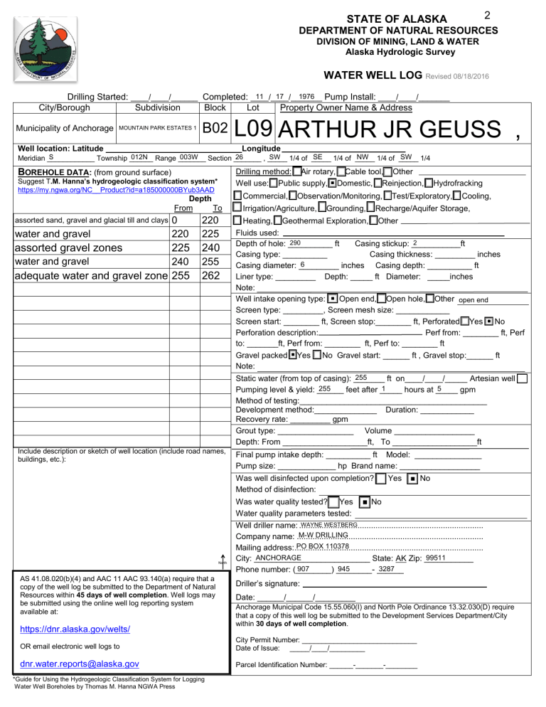
STATE OF ALASKA 2 DEPARTMENT OF NATURAL RESOURCES DIVISION OF MINING, LAND & WATER Alaska Hydrologic Survey WATER WELL LOG Revised 08/18/2016 11 17 1976 Pump Install: ____/____/_______ Drilling Started: ____/____/______ Completed: ____/____/_______ City/Borough Subdivision Block Lot Property Owner Name & Address Municipality of Anchorage MOUNTAIN PARK ESTATES 1 B02 Well location: Latitude L09 ARTHUR JR GEUSS , Longitude SE NW 1/4 of _____ SW 1/4 012N Range _______ 003W Section _______ S 26 SW 1/4 of _____ Meridian ____________ Township ______ , _____ 1/4 of _____ Drilling method: Air rotary, Cable tool, Other Well use: Public supply, ■ Domestic, Reinjection, Hydrofracking BOREHOLE DATA: (from ground surface) Suggest T.M. Hanna’s hydrogeologic classification system* https://my.ngwa.org/NC__Product?id=a185000000BYub3AAD Depth From To water and gravel 0 220 220 225 assorted gravel zones 225 240 water and gravel 240 255 adequate water and gravel zone 255 262 assorted sand, gravel and glacial till and clays Commercial, Observation/Monitoring, Test/Exploratory, Cooling, Irrigation/Agriculture, Grounding, Recharge/Aquifer Storage, Heating, Geothermal Exploration, Other Fluids used: 290 2 Depth of hole: __________ ft Casing stickup: ___________ft Casing type: __________ Casing thickness: _________ inches 6 Casing diameter: _________ inches Casing depth: __________ ft Liner type: _________ Depth: _____ ft Diameter: _____inches Note: Well intake opening type: ■ Open end, Open hole, Other open end Screen type: _________, Screen mesh size: ____________ Screen start: ________ ft, Screen stop:________ ft, Perforated Yes ■ No Perforation description: Perf from: ________ ft, Perf to: _______ft, Perf from: ________ ft, Perf to: ________ ft Gravel packed ■ Yes No Gravel start: ______ ft , Gravel stop:______ ft Note: 255 Static water (from top of casing): _______ ft on____/____/_____ Artesian well 255 1 5 Pumping level & yield: ______ feet after _____ hours at _____ gpm Method of testing:__________________________________________ Development method:______________ Duration: ____________ Recovery rate: _________ gpm Grout type: _________________ Volume __________________ Depth: From ___________________ft, To ___________________ft Include description or sketch of well location (include road names, buildings, etc.): Final pump intake depth: __________ ft Model: _______________ Pump size: _____________ hp Brand name: __________________ Was well disinfected upon completion? Yes Method of disinfection: Was water quality tested? Yes Water quality parameters tested: North AS 41.08.020(b)(4) and AAC 11 AAC 93.140(a) require that a copy of the well log be submitted to the Department of Natural Resources within 45 days of well completion. Well logs may be submitted using the online well log reporting system available at: https://dnr.alaska.gov/welts/ ■ No ■ No WAYNE WESTBERG Well driller name: .................................................................................. M-W DRILLING Company name: ................................................................................... PO BOX 110378 Mailing address: .................................................................................... ANCHORAGE 99511 City: __________________________ State: AK Zip: ___________ 907 945 3287 Phone number: (________) ______________ Driller’s signature: Date: ______/______/_________ Anchorage Municipal Code 15.55.060(I) and North Pole Ordinance 13.32.030(D) require that a copy of this well log be submitted to the Development Services Department/City within 30 days of well completion. OR email electronic well logs to City Permit Number: _____________________________ Date of Issue: _____/____/_________ dnr.water.reports@alaska.gov Parcel Identification Number: ______-_______-________ *Guide for Using the Hydrogeologic Classification System for Logging Water Well Boreholes by Thomas M. Hanna NGWA Press 2
