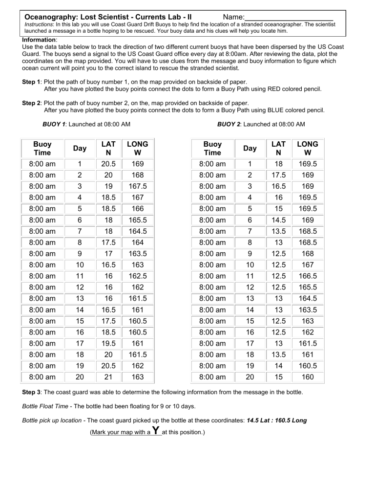
Oceanography: Lost Scientist - Currents Lab - II Name: Instructions: In this lab you will use Coast Guard Drift Buoys to help find the location of a stranded oceanographer. The scientist launched a message in a bottle hoping to be rescued. Your buoy data and his clues will help you locate him. Information: Use the data table below to track the direction of two different current buoys that have been dispersed by the US Coast Guard. The buoys send a signal to the US Coast Guard office every day at 8:00am. After reviewing the data, plot the coordinates on the map provided. You will have to use clues from the message and buoy information to figure which ocean current will point you to the correct island to rescue the stranded scientist. Step 1: Plot the path of buoy number 1, on the map provided on backside of paper. After you have plotted the buoy points connect the dots to form a Buoy Path using RED colored pencil. Step 2: Plot the path of buoy number 2, on the, map provided on backside of paper. After you have plotted the buoy points connect the dots to form a Buoy Path using BLUE colored pencil. BUOY 1: Launched at 08:00 AM BUOY 2: Launched at 08:00 AM Buoy Time Day LAT N LONG W Buoy Time Day LAT N LONG W 8:00 am 1 20.5 169 8:00 am 1 18 169.5 8:00 am 2 20 168 8:00 am 2 17.5 169 8:00 am 3 19 167.5 8:00 am 3 16.5 169 8:00 am 4 18.5 167 8:00 am 4 16 169.5 8:00 am 5 18.5 166 8:00 am 5 15 169.5 8:00 am 6 18 165.5 8:00 am 6 14.5 169 8:00 am 7 18 164.5 8:00 am 7 13.5 168.5 8:00 am 8 17.5 164 8:00 am 8 13 168.5 8:00 am 9 17 163.5 8:00 am 9 12.5 168 8:00 am 10 16.5 163 8:00 am 10 12.5 167 8:00 am 11 16 162.5 8:00 am 11 12.5 166.5 8:00 am 12 16 162 8:00 am 12 12.5 165.5 8:00 am 13 16 161.5 8:00 am 13 13 164.5 8:00 am 14 16.5 161 8:00 am 14 13 163.5 8:00 am 15 17.5 160.5 8:00 am 15 12.5 163 8:00 am 16 18.5 160.5 8:00 am 16 12.5 162 8:00 am 17 19.5 161 8:00 am 17 13 161.5 8:00 am 18 20 161.5 8:00 am 18 13.5 161 8:00 am 19 20.5 162 8:00 am 19 14 160.5 8:00 am 20 21 163 8:00 am 20 15 160 Step 3: The coast guard was able to determine the following information from the message in the bottle. Bottle Float Time - The bottle had been floating for 9 or 10 days. Bottle pick up location - The coast guard picked up the bottle at these coordinates: 14.5 Lat : 160.5 Long (Mark your map with a Y at this position.) Step 4: (Be sure you have complete Step 3 on previous page) Using the information provided from the Buoys and your completed map, answer the following questions. 1] Which Buoy current did the Bottle most likely follow? Buoy 1 or Buoy 2? 2] Which direction on the map do the currents seem to originate from? 3] Which buoy current seems to pass the least number of islands? 4] In the message, the scientist said his boat sank just North of a large island. Using your evidence from the buoys and bottle, place a large X at this position 5] If each map grid is 110 kilometers square, about how many kilometers did the bottle travel from the island to the bottle “pick up” location?
