NC Regions: Coastal Plain, Piedmont, Mountains Worksheet
advertisement
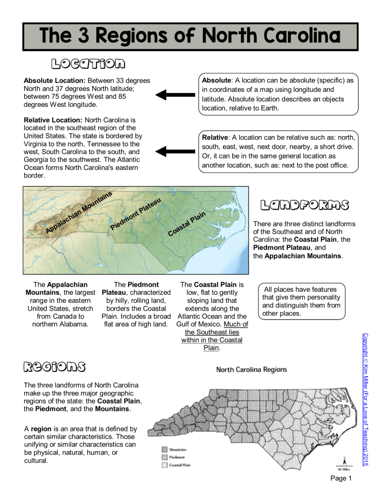
The 3 Regions of North Carolina LOCATION Absolute: A location can be absolute (specific) as in coordinates of a map using longitude and latitude. Absolute location describes an objects location, relative to Earth. Absolute Location: Between 33 degrees North and 37 degrees North latitude; between 75 degrees West and 85 degrees West longitude. Relative Location: North Carolina is located in the southeast region of the United States. The state is bordered by Virginia to the north, Tennessee to the west, South Carolina to the south, and Georgia to the southwest. The Atlantic Ocean forms North Carolina's eastern border. ins a t n p Ap u Mo n ia ch a l a dm Pie u tea a l tP on Relative: A location can be relative such as: north, south, east, west, next door, nearby, a short drive. Or, it can be in the same general location as another location, such as: next to the post office. LANDFORMS P tal s a Co n lai All places have features that give them personality and distinguish them from other places. Copyright © Kim Miller (For a Love of Teaching) 2015 The Appalachian The Piedmont The Coastal Plain is Mountains, the largest Plateau, characterized low, flat to gently range in the eastern by hilly, rolling land, sloping land that United States, stretch borders the Coastal extends along the from Canada to Plain. Includes a broad Atlantic Ocean and the northern Alabama. flat area of high land. Gulf of Mexico. Much of the Southeast lies within in the Coastal Plain. There are three distinct landforms of the Southeast and of North Carolina: the Coastal Plain, the Piedmont Plateau, and the Appalachian Mountains. REGIONS The three landforms of North Carolina make up the three major geographic regions of the state: the Coastal Plain, the Piedmont, and the Mountains. A region is an area that is defined by certain similar characteristics. Those unifying or similar characteristics can be physical, natural, human, or cultural. Page 1 Coastal Plain North Carolina's Coastal Plain is low, flat land along the Atlantic Ocean. It is often divided into two parts - the Outer Coastal Plain and the Inner Coastal Plain. The Outer Coastal Plain is made up of the Outer Banks and the Tidewater region. The Outer Banks are a string of barrier islands separated from the mainland by sounds or inlets. The largest islands in the Outer Banks are Bodie, Hatteras, Ocracoke, Portsmouth, and the Core Banks. Three capes are part of the Outer Banks: Cape Hatteras, Cape Lookout, and Cape Fear. Near these capes are dangerous shoals, or underwater sandbars which are hazards to ships. Cape Hatteras is known as the Graveyard of the Atlantic because shifting sand has caused many ships to run aground. The Outer Banks stretch more than 175 miles along the coast. The Tidewater is the area of land along the coast that is close to sea level. All the beaches of North Carolina are located here. The mouths of the major streams and rivers empty into sounds or the ocean. There are seven sounds in the Tidewater region: Pamlico, Albemarle, Currituck, Croatan, Roanoke, Core, and Bogue Sounds. This region has many low-lying areas called wetlands, where water covers the land. The Great Dismal Swamp, a series of swamps scattered from Virginia, to North Carolina, South Carolina, and Georgia, is North Carolina's largest wetland area. It covers about 750 square miles, making it one of the largest swamps in the United Swamps. The Tidewater is the only place in the world where the Venus Flytrap plant grows naturally. One of the Coastal Plain's chief natural resources was once a vast band of longleaf pine forests, almost all of which were tapped for tar by the early twentieth century. Peanuts and potatoes remain important crops in the northern Coastal Plain, while blueberries, strawberries, watermelons, and sweet potatoes grow in the southern portion. Tobacco, though in decline, was still a significant eastern North Carolina crop in the early 2000s. Large livestock operations (poultry and pork producers) have created employment opportunities across the region, as has large-scale commercial forestry. Coastal Plain waters offer fishermen endless opportunities. Commercial fishing brings fresh, local seafood to market and is a way of life in the coastal economy. Inner Coastal Plain Sandhills e ut O s nk a rB Tidewater Cape Hatteras (Graveyard of the Atlantic) A sound is a wide area of water that connects two larger bodies of water, and forms a channel between the mainland or an island. An inlet is a narrow area of water between two islands that leads to the land from the sea or a lake. A cape is a strip of land projecting into a body of water. You can usually find a lighthouse on a cape. A lighthouse shines a light so boats and ships don't run into the land. A natural resource is anything found in nature that can be used by humans. Page 2 Copyright © Kim Miller (For a Love of Teaching) 2015 The Inner Coastal Plain, a higher, drier area, begins west of the Tidewater. The rich, sandy soil here is some of the state's best farmland. In the southwestern corner of the Inner Coastal Plain are the Sandhills, a small region of rolling, sandy hills. This area has the highest elevation on the Coastal Plain, ranging from about 900 to 1,000 feet above sea level. This area is also famous for their peach growing industry. Outer Coastal Plain Piedmont The Piedmont region is considered the economic center of our state. This region is located in the middle of the North Carolina, between the Coastal Plain and the Mountain regions. Piedmont is a French word meaning "foot of the mountain." The elevations of this region range from about 300 feet in the western Coastal Plain to about 1,500 feet near the mountains. The boundary between the Coastal Plain and the Piedmont is called the fall line or fall zone. Along this line, rivers flow from the older, harder rocks of the Piedmont to the softer rocks of the coastal Plain. Along the fall line, rivers form shoals, low waterfalls, and rapids. Below the fall line, streams are usually sluggish and smooth-flowing. Above the fall line, the streams are rocky and shallow, making boating difficult. The land of the Piedmont is called a plateau because it is high and mostly flat. The Piedmont covers about the same amount of area as the Coastal Plain but it is higher in elevation. Seven major rivers and their tributaries (Dan, Tar, Neuse, Cape Fear, Yadkin, Catawba and Broad) drain the eastern side of the Blue Ridge, carving narrow, deep valleys in the hard rocks of the Piedmont. These streams and their valleys are not passable but they have supplied numerous sites for waterpower uses. Piedmont Plateau Fall Line A fall line is a line joining the waterfalls on numerous rivers that marks the point where each river descends from the upland to the lowland . A shoal is a place where a sea, river or other body of water becomes shallow. A plateau is a broad flat area of high land raised above the surrounding land. A tributary is a stream flowing into a larger stream or lake. In 1799 an important natural resource found in the Piedmont included gold and other valuable metals. This was the site of the first United States gold rush! Other resources include textiles, tobacco and furniture. Over time this area has advanced from relying solely on agriculture resources to a more technological region. Research Triangle Park lies near the eastern end of the Piedmont, between Raleigh, Durham, and Chapel Hill. It is the largest planned research center in the United States and has brought the Piedmont greater economic growth throughout the years. Do your own research! Find out what happens inside Research Triangle Park. Page 3 Copyright © Kim Miller (For a Love of Teaching) 2015 The Piedmont Urban Crescent is a semicircular band of cities and towns extending from Raleigh to Charlotte, including Durham, Burlington,Greensboro, Winston-Salem, High Point, Salisbury, and many smaller communities. This area of the piedmont has been very successful in urban growth and economic progress. The state's biggest newspapers and television stations are located in the Urban Crescent, as are the leading colleges, universities and high technology industries. Mountains The western part of the state is the Mountain region which rises abruptly from the Piedmont Plateau. It is smaller in area than the Piedmont and Coastal Plain. The elevation in this region reaches to more than one mile high. The Blue Ridge Mountains separate the Piedmont from the Mountain region. Other ranges in the Mountain region include the Bald, Balsam, Black, Brushy, Great Smoky, Iron, Pisgah, Stone, and Unaka. All of these ranges are part of the larger Appalachian Mountains, possibly the oldest mountains in the United States. North Carolina has at least 40 mountains that rise to 6,000 feet and 100 that rise more than 5,000 feet. Mount Mitchell in the Black Mountain range is 6,684 feet high. This is the highest point in North Carolina and the highest in the United States east of the Mississippi River. The Blue Ridge Mountains form the Eastern Continental Divide which separates the waters that flow into the Gulf of Mexico from the waters that flow into the Atlantic ocean. Rivers on the eastern side of the divide flow east toward the Atlantic Ocean. Rivers that run on the western side of the divide flow toward the Tennessee and Ohio rivers and into the Gulf of Mexico. Rivers that start on the eastern side of the Blue Ridge in North Carolina include the Roanoke, Yadkin, Catawba, Broad and Savannah Rivers. The major westward flowing rivers are the New, French Broad, Little Tennessee and Hiawassee. The New River, despite its name, is very old! It is one of North America’s oldest rivers, created between 10 million and 360 million years ago. It is believed to be the only major river in the United States to flow north. ue Bl dg Ri e ou M Eastern Continental Divide Fun Fact: If you poured a bucket of water on the Eastern Continental Divide, water flowing to the east side would end up in the Atlantic Ocean. Water flowing to the west side of the divide would end up in the Gulf of Mexico! A mountain range is a line of mountains connected by high ground. Agriculture is the science or occupation of cultivating the soil, producing crops, and raising livestock. Fun Fact: Some geologists believe the New to be the second-oldest river in the world, behind the Nile River in Egypt. A mineral is a naturally occurring element or compound. Each mineral has its own crystal and chemical makeup. It also has physical qualities such as hardness and color. All rocks are made up of minerals. The Blue Ridge Parkway, our nation's most scenic byway, stretches 250 miles through the North Carolina mountains, from Cherokee and the entrance to the Great Smoky Mountains National Park to the Virginia-North Carolina border and beyond. Page 4 Copyright © Kim Miller (For a Love of Teaching) 2015 The major agricultural crops found in the Mountain region include: sweet corn, wheat, oats, barley, hay, tobacco, fruits and vegetables. Cattle and large numbers of chickens are raised for sale at market. The most prominent industry in the mountains is the raising and selling of Fraser Fir Christmas Trees. North Carolina is currently ranked 2nd in the nation in number of trees harvested each year. North Carolina's Mountain region is a major source of mineral resources including: feldspar, mica, emerald and granite. Forestry, mining, agriculture, and tourism provide income to many Mountain residents. Growing cities such as Asheville, Boone, and Hendersonville offer a variety of diverse ns ai t n
