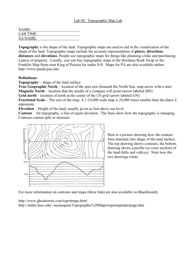
Lab #8: Topographic Map Lab NAME: _________________________ LAB TIME:______________________ TA NAME:______________________ Topography is the shape of the land. Topographic maps are used to aid in the visualization of the shape of the land. Topographic maps include the accurate representation of places, directions, distances and elevations. People use topographic maps for things like planning a hike and purchasing a piece of property. Locally, you can buy topographic maps at the Horsham Book Swap or the Franklin Map Store near King of Prussia for under $10. Maps for PA are also available online: http://www.pasda.psu.edu/ Definitions: Topography – shape of the land surface True Geographic North – location of the spin axis (beneath the North Star, map arrow with a star) Magnetic North – location that the needle of a compass will point (arrow labeled MN) Grid north – location of north at the center of the US grid (arrow labeled GN) Fractional Scale – The size of the map. A 1:24,000 scale map is 24,000 times smaller than the place it represents. Elevation – Height of the land, usually given as feet above sea level Contour – for topography, a line of equal elevation. The lines show how the topography is changing. Contours cannot split or intersect Here is a picture showing how the contour lines translate into shape of the land surface. The top drawing shows contours, the bottom drawing shows a profile (or cross section) of the land (hills and valleys). Note how the two drawings relate. For more information on contours and maps (these links are also available on Blackboard): http://www.ghosttowns.com/topotmaps.html http://raider.muc.edu/~mcnaugma/Topographic%20Maps/topomapindexpage.htm Border of the Map 1. What is the name of the map?______________________ 2. Who published this map?_________________________ 3. What is the publish date of this map?_____________________ 4. How much difference is there between magnetic north and geographic north on this map (in degrees)?________________ 5. If you were to leave this map and need to find the map immediately adjacent to the southwest what is the name of the map would you need to look up?_________________ 6. Note the three bar scales. What are the units for each bar?________________ 7. What is the fractional scale of the map?__________________ 8. Properly report the latitudes and longitudes that bound this map. NE Lat___________ SE Lat_____________ Long____________ NW Lat___________ Long___________ Long_____________ SW Lat___________ Long___________ 9. This is a how many minute series map?_________________ 10. What is the latitude and longitude of the center of this map? ____________________ Map Symbols 1. What are the pink shaded areas on the map?____________ 2. What are the green shaded areas on the map?__________ 3. What are the blue features?___________ 4. What are the bold red lines?___________ 5. What are the black geometric shapes?____________ Distance If you choose to use the fractional scale to calculate distances you can use a simple equation to convert measured inches to true distance in miles. You can also measure distance using the scale bars to convert ruler distance to distance on a map. Show your work for each problem. 1. What is the distance in miles from the top of the map to the bottom?__________ 2. What is the distance in miles from the eastern side of the map to the western?__________ 3. Calculate the area encompassed by this map?____________ 4. How wide is the Susquehanna River? Measure at one of the bridges and list which bridge you measured. _________________________________ 5. What is the distance in miles from the radio tower on Second mountain to Hecton?________ Direction 1. Camp Reilly is in what direction from the Radio tower?_________ 2. If you were to walk from Good Hope Mill to Rockville what direction would you be walking?_______ Elevation Brown lines on the map are called contour lines and they represent lines of equal elevation. As long as you stay on that line you remain at that elevation. There are two types of brown lines, bold lines and fine lines. 1. Find a bold brown line. Follow the line until you find a number and record it.___________ 2. Find the next adjacent bold line and record its elevation.___________ 3. What is the change in elevation between these two lines?__________ 4. How many fine lines are between the bold lines?_______ 5. What is the change in elevation between the fine lines?__________ This is the contour interval for this map and it is also written at the bottom of the map below the three bar scales. Contour patterns Find an example of each contour pattern in the northeast quadrant of the map and name a nearby place. 1. Steep topography _______________________ 2. Shallow or flat topography ________________ 3. Hill _____________________ 4. Stream valley ______________ 5. What is the elevation of the Harrisburg Country Club in the northeast quadrant of the map?___________ 6. What is the elevation of the radio tower on Second Mountain?_________ 7. What is the elevation of Hecton?____________ 8. What is the change in elevation between Hecton and the Radio Tower?__________ To supply water for a lodge at the Radio Tower, a pipeline and road from Hecton would be needed to move up river water. PENNDOT forbids roads that have greater than 7% (or 0.07) gradient. If you divide the change in elevation (#8 above) by the distance (#5 earlier section), you can calculate the gradient or slope from the Second Mountain radio towerto Hecton. Show your work and use the same units for elevation and distance (e.g., feet) 9. What is the gradient? _____________ Does it violate PENNDOTs rule? _________ 10. Can you see Berrier Island from the top of Blue Mountain? ___ From the top of Cove Mountain? ___ Explain your answer. 11. Why are there more buildings in the southern portion of the map than the northern portion of the map? How do the landforms affect development? Contouring 1. Now try contouring the shaded relief map of Hawaii. The shaded relief gives you clues about how the contour lines show elevation. Remember, do not let contour lines cross. Along every contour line you should have lower elevations on one side of the line and higher on the other. Use a 3000 ft contour interval. Almost all of these data points fell on a contour line. Sometimes your data will be in between the lines, and you need to interpolate (estimate based on surrounding values). Use interpolation to give some elevation values between the lines. 2. What is the elevation at the point marked X? ____________________ 3. What is the elevation at the point marked 0?______________________


