IRJET- Advanced Waypoints Analytics for Automated Drones
advertisement

International Research Journal of Engineering and Technology (IRJET)
e-ISSN: 2395-0056
Volume: 06 Issue: 04 | Apr 2019
p-ISSN: 2395-0072
www.irjet.net
ADVANCED WAYPOINTS ANALYTICS FOR AUTOMATED DRONES
Subrahmanya H M1, Srinivas G1, Chandan Jayram2
1Dept. of ISE, The National Institute of Engineering, Mysore
Professor, Dept of ISE, The National Institute of Engineering, Mysore, Karnataka, India
---------------------------------------------------------------------***---------------------------------------------------------------------2Asst.
Abstract - Currently drones are manually operated.
Automating drones to calculate its own waypoints and
shortest path is required for building smart drones. We have
developed an algorithm which takes coordinates of grid as
input, plots waypoints, finds shortest path and helps drones to
take this path. It also has various machine learning algorithms
for various applications.
After plotting waypoints, our model uses Google API to get
the altitude. Now all waypoints will have all three
coordinates. Waypoints along with grid border are plotted
on Google maps for better analysis.
Key Words: Waypoint, Shortest Path, Machine learning,
Drones, Automation
1. INTRODUCTION
A drone is a semi-autonomous aircraft that can be controlled
and operated remotely by using a computer along with a
radio-link. Commercially-available drones are increasingly
been used in a variety of applications such as monitoring and
surveillance, search and rescue operations, media coverage
of public events, and aerial package delivery. However, with
the growing popularity and use of drones for consumer
applications, the number of incidents involving drones is
also increasing dramatically. Ensuring a hazard-free, safe
flight is also equally important for indoor applications.
Autonomous drones has various applications such as
disaster management, finding fire in forests, finding signal
strength around a tower in telecom industry.
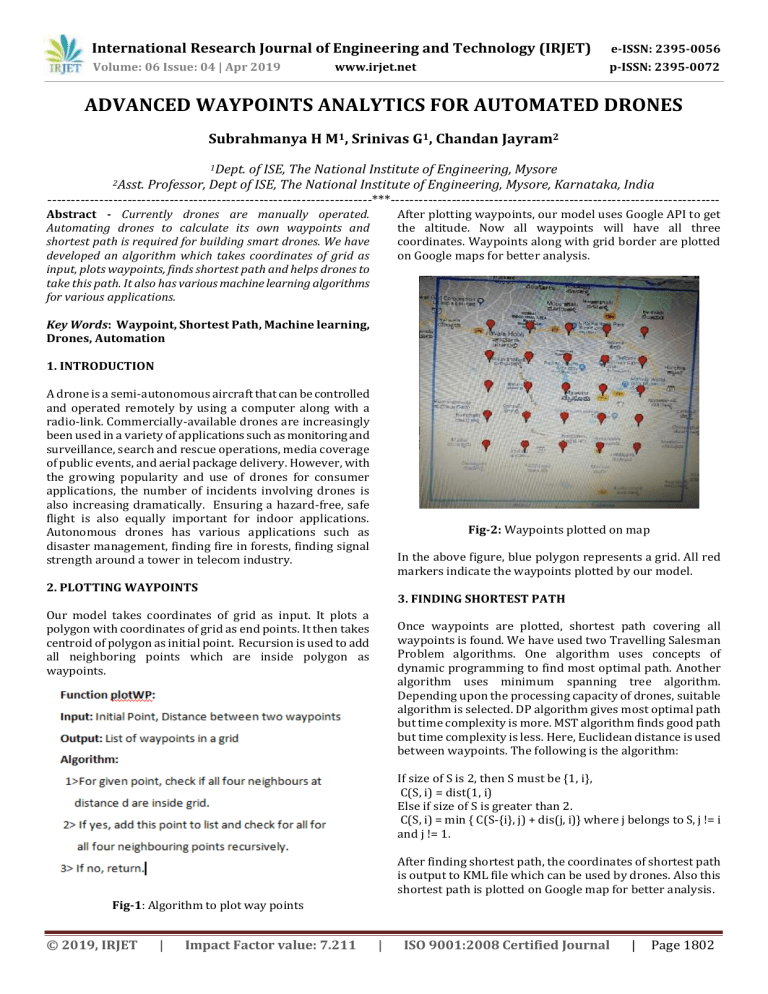
Fig-2: Waypoints plotted on map
In the above figure, blue polygon represents a grid. All red
markers indicate the waypoints plotted by our model.
2. PLOTTING WAYPOINTS
3. FINDING SHORTEST PATH
Our model takes coordinates of grid as input. It plots a
polygon with coordinates of grid as end points. It then takes
centroid of polygon as initial point. Recursion is used to add
all neighboring points which are inside polygon as
waypoints.
Once waypoints are plotted, shortest path covering all
waypoints is found. We have used two Travelling Salesman
Problem algorithms. One algorithm uses concepts of
dynamic programming to find most optimal path. Another
algorithm uses minimum spanning tree algorithm.
Depending upon the processing capacity of drones, suitable
algorithm is selected. DP algorithm gives most optimal path
but time complexity is more. MST algorithm finds good path
but time complexity is less. Here, Euclidean distance is used
between waypoints. The following is the algorithm:
If size of S is 2, then S must be {1, i},
C(S, i) = dist(1, i)
Else if size of S is greater than 2.
C(S, i) = min { C(S-{i}, j) + dis(j, i)} where j belongs to S, j != i
and j != 1.
After finding shortest path, the coordinates of shortest path
is output to KML file which can be used by drones. Also this
shortest path is plotted on Google map for better analysis.
Fig-1: Algorithm to plot way points
© 2019, IRJET
|
Impact Factor value: 7.211
|
ISO 9001:2008 Certified Journal
|
Page 1802
International Research Journal of Engineering and Technology (IRJET)
e-ISSN: 2395-0056
Volume: 06 Issue: 04 | Apr 2019
p-ISSN: 2395-0072
www.irjet.net
capacity of the drone. It then gives the shortest path
coordinates in a kml file to drone. Adding generalized
machine learning models gives drone the ability to predict or
classify based on given dataset. This improves the
applications of drones. They can be used to predict signal
strength, to diagnose problems in signal towers, find natural
disasters. These algorithms makes drones more powerful.
ACKNOWLEDGEMENT
We are proud and grateful to have been given an opportunity
to present an idea such as ours. To our principal, Dr. G S Ravi,
we are extremely grateful for his kind permission to carry
out our work. We are grateful to Rajiv Narahari and Karthik
of NOKIA Systems, Bangalore for their constant support. Our
sincere thanks to the Department of Information Science and
Engineering, NIE, Mysuru.
Fig-3: Shortest path plotted on map
We are indebted to Mr. Chandan Jayram, our project guide
for his constant support and valuable insights to the project .
When we were lost, he helped us find a path and we will be
ever grateful.
In the above figure, blue polygon is the grid. Red markers
indicate the waypoints plotted by our model. Green path
connecting all waypoints is the shortest path calculated by
our algorithm
REFERENCES
4. GENRALISED ML ALGORITHMS
[1]
To make drones smart, we have included many machine
learning algorithms in our model. The catch here is that
efficiency of model varies with dataset. Since dataset varies
according to applications of drone, a pre defined algorithm
cannot be chosen. Depending upon the number of dependent
variables, decision of using regression model or classification
model is done. Simple linear regression, multiple linear
regression, polynomial regression, decision tree and random
forest are some of regression models used. All models will be
applied and the one with least mean error will be chosen.
This will predict the most accurate values. Prediction of
signal strength around a base station in telecom industry is
one of its application. Logistic regression, KNN classification,
Naïve-Bayes model, support vector machine, kernel SVM,
Decision tree and Random forest are the models used. Here,
grid search is used to get the best parameters. After getting
best parameters, 10-folds cross validation is used to pick out
the most accurate model and that model is used. Diagnosis of
problems in a tower is one of the application of classification
models in telecom industry. This is coded in such a way that
even if there is a need to add some more models, very less
modification needs to be done.
[2]
[3]
[4]
[5]
5. CONCLUSION
[6]
Drones have many real life applications. They are used in
disaster relief, archeology, law enforcement and crimes,
aerial surveillance and also in military. Since current drones
are controlled drones, they need input from user each
second. Automation of drones removes that requirement.
User needs to just give the coordinates of grid. The rest will
be taken care by the drone itself. It will take care of plotting
waypoints at specified distance, finding shortest path
depending upon number of waypoints and performance
© 2019, IRJET
|
Impact Factor value: 7.211
|
Amin Majd, Adnan Ashraf, Elena Troubitsyna, Masoud
Daneshtalab, “Integrating Learning, Optimization, and
Prediction for Efficient Navigation of Swarms of
Drones”, 2018 26th Euromicro International Conference
on Parallel, Distributed and Network-based Processing
(PDP).
Sungwoo Kim, Ilkyeong Moon, “Travelling Salesman
Problem with a Drone”, IEEE Transactions on Systems,
Man, and Cybernetics: Systems Year: 2019, Volume: 49 ,
Issue: 1.
Hristijan Gjorshevski, Kire Trivodaliev, Ivana Nizetic
Kosovic, Slobodan Kalajdziski, Biljana Risteska
Stojkoska, “Dynamic Programming Approach for Drone
routes planning”, 2018 26th Telecommunications
Forum (TELFOR).
Ritu Shenoy, B. K. Keshavan, “Hybrid drone for data
transaction”, 2017 IEEE International Conference on
Smart Energy Grid Engineering (SEGE).
Jinsoo Park, Yoojoong Kim, Junhee Seok, “Prediction of
information propagation in a drone network by using
machine learning”, 2016 International Conference on
Information
and
Communication
Technology
Convergence (ICTC).
Jiri Stastny, Vladislav Skorpil, Lubomir Cizek,
“Travelling Salesman Problem optimization by means of
graph-based algorithm”, 2016 39th International
Conference on Telecommunications and Signal
Processing (TSP).
ISO 9001:2008 Certified Journal
|
Page 1803


