Traverse
advertisement

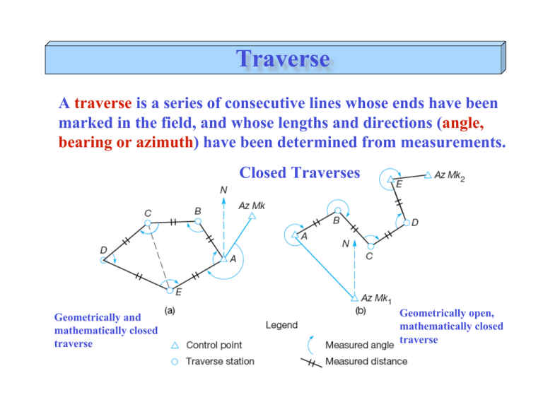
Traverse A traverse is a series of consecutive lines whose ends have been marked in the field, and whose lengths and directions (angle, bearing or azimuth) have been determined from measurements. Closed Traverses Geometrically and mathematically closed traverse Geometrically open, mathematically closed traverse Traverse Open Traverse Geometrically and mathematically Open Open traverses should be avoided because they offer no means of checking for errors or mistakes Closed Traverse Step 1: Angle Misclosure For a closed loop traverse with n internal angles, the check that is used is: 0 = n " 2 *180 # ( ) Check the error with the Permissible misclosure (c) ! c =K n ! n is the number of angles K is a constant depends on the level of accuracy. Closed Traverse Example 10.1 (textbook) Check Interior Angle Closure Observed A B C D E = 1000 45’ 37” = 2310 23’ 43” = 170 12’ 59” = 890 03’ 28” = 1010 34’ 24” Total = 540000’ 11” Adjusted 1000 45’ 35” 2310 23’ 40” 170 12’ 56” 890 03’ 27” 1010 34’ 22” = 5400 00’ 00” Should = 5400 00’ 00” = (n-2)*180 Misclosure = 00’ 11” = 11” Adjustment = 11/5 = -2.2” per angle Closed Traverse Step 2: Compute Azimuths/Bearings Example 10-2 (textbook) Azimuths are horizontal angles measured clockwise from any reference meridian (North). The bearing is the actual horizontal angles between a reference meridian (North or South) and the line. Closed Traverse Step 2: Compute Azimuths/Bearings Example 10-2 (textbook) Adjusted Angles A = 1000 45’ 35” B = 2310 23’ 40” C = 170 12’ 56” D = 890 03’ 27” E = 1010 34’ 22” Azimuths of AW = 2340 17’ 18” Measured angle WAE = 1510 52’ 24” AB = 2340 17’ 18”+ 1510 52’ 24”+ 1000 45’ 35”- 3600 = 126055’17” BA = 126055’17” + 1800 = 306055’17” BC = 306055’17”+ 2310 23’ 40” = 538018’58” -3600 = 1780 18’58” CB = 1780 18’58” + 180 = 358018’58” etc … Closed Traverse Step 3: Compute Latitudes and Departures Once all the azimuths are calculated, traverse closure is checked by computing the departure, or easting (ΔX) and latitude, or northing (ΔY) of each line. "X = L sin # "Y = L cos # where L is the horizontal length ! Example 10-3 (textbook) Closed Traverse Step 4: Linear Misclosure and Relative Precision If all angles and distances were measured perfectly, the algebraic sum of the departures of all lines in the traverse should equal zero. Likewise, the algebraic sum of all latitudes should equal zero. Cx = "#X Cy = "#Y where: Cx = total closure distance of X Cy = total closure distance of Y ! Example 10-3 (textbook). Closed Traverse Step 4: Linear Misclosure and Relative Precision The error of linear closure (E) is determined using Pythagorean’s Theorem as: E = Cx2 + Cy2 E Relative Pr ecision = P P is the traverse perimeter or total length Example 10-3 (textbook). Closed Traverse Step 5: Traverse Adjustment (Compass Rule) For any closed traverse the linear misclosure must be adjusted (or distributed) throughout the traverse to “close” or “balance” the figure. ABx _ Corr = Cx ABy _ Corr = Cy AB P AB P ABx_Corr is amount of adjustment for length AB in the X direction, ! ABy_Corr is amount of adjustment for length AB in the Y direction, Example 10-4 (textbook) Closed Traverse Step 6: Calculate Final Coordinates Using adjusted lats and deps and the coordinates of your starting point (A), compute coordinates of all traverse points (B, C, D, E) X = X coordinate of the previous point + ΔX Y = Y coordinate of the previous point + ΔY Example 10-4 (textbook) Field Procedure Objective ♦ ♦ ♦ ♦ Learn the principles of running a closed field traverse. A Learn how to compute a traverse (by hand or using Excel) and properly adjust the measured values of a closed traverse to achieve mathematical closure. Determine the error of closure and compute the accuracy of the work. Establish horizontal control points for the Area A. D Area A B C Field Procedure Area A ♦ ♦ ♦ Azimuth of AB is given (232o42’40”). Easting and Northing of A (X,Y) ♦ (324540.698 m, 5270414.258 m) ♦ Newfoundland-MTM Zone 1 N CP1 Start your traverse on one corner of the area you staked out. ♦ Measure the horizontal angle and distance between the two adjacent points. ♦ Each horizontal angle should be measured B using the telescope in direct and reverse CP2 position. Record the average of the angles. ♦ Compute the misclosure for the geometry and check that the internal angles of your parcel sum to (n-2) *180 (should be within ± 30’ of 360°). A D Area A C


